Area Overview for TS21 2EB
Photos of TS21 2EB
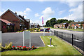
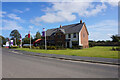
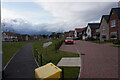
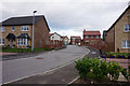
18 photos from this area
Area Information
Key information about the TS21 2EB including its size, population, and administrative classification.
- Area Type
- Postcode
- Area Size
- 1.4 hectares
- Population
- 1856
- Population Density
- 1895 people/km²
House Prices in TS21 2EB
22
Properties
£83,364
Average Sold Price
£29,000
Lowest Price
£145,000
Highest Price
Showing 22 properties
| Address | Type | Beds | Baths | Last Sale Price | Last Sale Date | |
|---|---|---|---|---|---|---|
| 13 Thurlow Road, Sedgefield, TS21 2EB | Terraced | 2 | 1 | £145,000 | Dec 2025 | |
| 9 Thurlow Road, Sedgefield, TS21 2EB | Terraced | 2 | 1 | £110,000 | Oct 2021 | |
| 7 Thurlow Road, Sedgefield, TS21 2EB | Terraced | 2 | - | £75,000 | Mar 2021 | |
| 11 Thurlow Road, Sedgefield, TS21 2EB | Terraced | 2 | - | £107,500 | Aug 2019 | |
| 12 Thurlow Road, Sedgefield, TS21 2EB | Terraced | 3 | 2 | £80,000 | Feb 2018 | |
| 19 Thurlow Road, Sedgefield, TS21 2EB | house | - | - | £95,000 | Aug 2015 | |
| 1 Thurlow Road, Sedgefield, TS21 2EB | Terraced | 2 | - | £85,000 | Oct 2013 | |
| 4 Thurlow Road, Sedgefield, TS21 2EB | Terraced | - | - | £104,000 | Jun 2012 | |
| 23 Thurlow Road, Sedgefield, TS21 2EB | Terraced | - | - | £125,000 | Aug 2009 | |
| 10 Thurlow Road, Sedgefield, TS21 2EB | Terraced | - | - | £59,995 | Jul 2002 |
Page 1 of 3
Energy Efficiency in TS21 2EB
Amenities
Schools
| Rank | School | Type | Entry gender | Ages |
|---|
Explore more schools in this area
Go to Schools tabDemographics
Household Size
One person
most common
Accommodation Type
Houses
most common
Tenure
66
majority
Ethnic Group
White
most common
Religion
N/A
most common
Household Composition
N/A
most common
Age
47
median
Adults (30-64 years)
most common
Household Deprivation
N/A
with no deprivation
NS-SEC
40
in Lower managerial occupations
Explore more demographic insights in this area
Go to Demographics tabPlanning
Planning Constraints
- Flood RiskPremium
- Ramsar Wetland SitesPremium
- Area of Outstanding Natural BeautyPremium
- Protected Nature ReservePremium
- Protected WoodlandPremium