Area Overview for Swarland
Photos of Swarland


Area Information
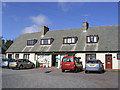
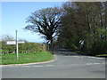
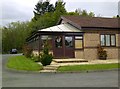
Swarland is a compact built-up area in England, spanning 90.9 hectares. Its character is defined by a mature population, with a median age of 70, suggesting a community rooted in stability and long-term residency. The area is predominantly owner-occupied, with 87% of homes in private hands, reflecting a sense of permanence. For those considering living in Swarland, the blend of practicality and quietude is evident. Proximity to two railway stations, including Acklington Railway Station, offers convenient access to nearby towns. Retail options are within reach, with Morrisons Daily and M&S Alnwick providing everyday essentials. Safety is a key draw, with a crime risk score of 94, placing it in the lower percentile for safety. Daily life here balances accessibility with tranquillity, making it appealing for those seeking a settled, low-stress environment. The area’s small scale and well-defined amenities create a cohesive, community-focused atmosphere, ideal for those prioritising security and familiarity over urban vibrancy.
- Area Type
- Built Up Area 250
- Area Size
- 90.9 hectares
- Population
- Not available
- Population Density
- Not available
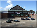
Residents of Swarland have access to a range of nearby amenities, including five retail outlets such as Morrisons Daily and M&S Alnwick, ensuring everyday shopping needs are met. These stores provide convenience for groceries, clothing, and other essentials, supporting a practical lifestyle. While the data does not mention parks or leisure facilities, the presence of multiple retail options suggests a focus on accessibility and community convenience. The area’s compact size means amenities are within practical reach, reducing the need for long commutes. For those valuing ease of access to shops and services, Swarland’s retail offerings contribute to a functional, low-maintenance daily routine. The combination of railway stations and nearby stores makes it suitable for those who prefer a self-contained, locally focused lifestyle.
Amenities
Schools
| Rank | A + A* % | School | Type | Entry gender | Ages |
|---|---|---|---|---|---|
| 1 | N/A | Swarland Primary School | primary | N/A | N/A |
Explore more schools in this area
Go to Schools tabDemographics
Swarland’s population is predominantly aged 70, with the most common age range encompassing the total population. This suggests a community with a significant proportion of older residents, which may influence local services and social dynamics. Home ownership is exceptionally high at 87%, indicating a strong preference for long-term residency over renting. The data does not specify household composition or accommodation types, but the high home ownership rate implies a stable, settled population. While no figures on ethnic diversity or religious composition are provided, the absence of such data does not detract from the area’s appeal for those prioritising safety and a mature demographic. The high median age may mean a focus on healthcare and community support services, though specific details on these are not available. Overall, Swarland’s demographics reflect a cohesive, older community with a clear emphasis on property ownership and long-term habitation.
Household Size
Accommodation Type
Tenure
Ethnic Group
Religion
Household Composition
Age
Household Deprivation
NS-SEC
Explore more demographic insights in this area
Go to Demographics tabPlanning
Planning Constraints
- Crime RiskLocked