Area Overview for Sadberge & Middleton St. George Ward
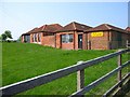
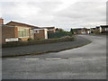
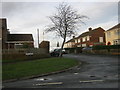
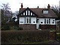
Photos of Sadberge & Middleton St. George Ward


Area Information
Living in Sadberge & Middleton St. George Ward offers a defined experience within a district borough unitary ward covering 56.8 km². This area serves 2,287 residents, creating a population density of 1,465 people per square kilometre. You will find a settlement character shaped by these specific boundaries rather than a sprawling urban sprawl. The community size suggests a close-knit environment where neighbours are likely familiar with one another. Daily life here revolves around local amenities and the specific geography of the ward. Prospective buyers should understand that this is a distinct administrative area with its own identity. The low population total means services operate on a smaller scale compared to larger towns. You can expect a quieter pace of life defined by the physical limits of the 56.8 square kilometres. Homebuyers seeking space will notice how the low density distributes inhabitants across the available land. This ward represents a specific pocket of the region with defined demographics and land use patterns. The compact nature of the area influences how residents access schools, shops, and transport links. Every decision about living in Sadberge & Middleton St. George Ward rests on this fundamental geographic reality.
- Area Type
- District Borough Unitary Ward
- Area Size
- 56.8 km²
- Population
- 2287
- Population Density
- 1465 people/km²
Demographics
The community in Sadberge & Middleton St. George Ward has a median age of 70 years. This figure defines the resident profile as predominantly older than the national average. You will see a population skewed significantly towards retirement age and late adulthood. Only a small fraction of households consists of younger families or singles under fifty. The sheer number of elderly residents changes the social fabric of this neighbourhood. Household composition reflects this ageing trend with fewer young children and couples without older dependents. Home ownership stands at an impressive 86% within the ward. This high rate indicates stability and long-term settlement rather than transient renting. Most people in Sadberge & Middleton St. George Ward hold the deed to their property. This statistic contrasts sharply with urban centres where rental markets often dominate. Accommodation types generally align with this ownership model, favouring detached or semi-detached housing for retirees. The area lacks significant demographic diversity data in the provided information, focusing instead on age and tenure. Deprivation levels are not explicitly detailed in the current dataset, leaving the quality of life to be inferred from the age profile alone. Understanding who lives here is crucial for evaluating schools near Sadberge & Middleton St. George Ward or community centres. The dominance of the 70-plus census group shapes every aspect of local life and service provision.
Household Size
Accommodation Type
Tenure
Ethnic Group
Religion
Household Composition
Age
Household Deprivation
NS-SEC
Explore more demographic insights in this area
Go to Demographics tabPlanning
Planning Constraints
- Flood RiskPremium
- Ramsar Wetland SitesPremium
- Area of Outstanding Natural BeautyPremium
- Protected Nature ReservePremium
- Protected WoodlandPremium