Area Overview for Lockwood
Photos of Lockwood

Area Information
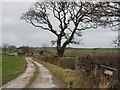
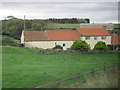
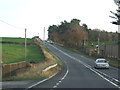
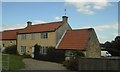
Living in Lockwood means settling into a civil parish that spans 39.5 square kilometres. This geography suggests a spread-out community where distances between locations are greater than you might find in a denser urban setting. The area is defined by its countryside character rather than high-density housing estates. You will discover that the landscape varies across this significant footprint, but the overarching identity remains rooted in rural England. There is no mention of specific village centres in the available details, yet the size implies pockets of settlement linked by local roads. Your daily life here involves navigating a large rural territory where access to amenities may require thought regarding travel distances. The environment is open and spacious, offering a different rhythm compared to town living. If you seek a home with ample surrounding land and a quieter atmosphere, the physical scale of Lockwood supports that lifestyle. However, the vastness also means you must consider how you will reach services compared to more compact neighbourhoods. The area stands as a distinct entity within the broader region, offering a specific type of rural experience that balances space with the structural needs of a civil parish. Understanding this scale is the first step to determining if Lockwood suits your vision for your future home.
- Area Type
- Parish
- Area Size
- 39.5 km²
- Population
- Not available
- Population Density
- Not available
Demographics
The community in Lockwood is heavily weighted towards older residents, with a median age of 70 years. This demographic profile indicates a neighbourhood where retirementliving or staying in a familiar home into old age is the norm. You should expect to see fewer families with young children and more households composed of couples or singles. Home ownership stands at 59%, a figure that reflects a significant portion of the population owning their dwellings outright or with a mortgage. This high rate of ownership often correlates with the age profile, as people tend to secure properties before or during retirement. The household composition data points to a stability that is characteristic of mature communities where residents have long-standing roots. Accommodation types typically align with the needs of older people, favouring single-story homes or properties with gardens suitable for accessibility. There is no indication of high urban density within the village structures. The demographic landscape suggests a peaceful environment where social activities may centre around local clubs or community halls rather than bustling school gates. Retail needs might differ from urban centres, focusing on essential goods, services, and healthcare rather than diverse consumer options.
Household Size
Accommodation Type
Tenure
Ethnic Group
Religion
Household Composition
Age
Household Deprivation
NS-SEC
Explore more demographic insights in this area
Go to Demographics tabPlanning
Planning Constraints
- Flood RiskPremium
- Ramsar Wetland SitesPremium
- Area of Outstanding Natural BeautyPremium
- Protected Nature ReservePremium
- Protected WoodlandPremium