Area Overview for NE9 6UF
Photos of NE9 6UF

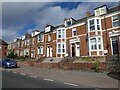


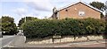
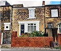
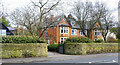
28 photos from this area
Area Information
Key information about the NE9 6UF including its size, population, and administrative classification.
- Area Type
- Postcode
- Area Size
- 1.2 hectares
- Population
- 1361
- Population Density
- 4248 people/km²
House Prices in NE9 6UF
21
Properties
£179,318
Average Sold Price
£59,000
Lowest Price
£276,000
Highest Price
Showing 21 properties
| Address | Type | Beds | Baths | Last Sale Price | Last Sale Date | |
|---|---|---|---|---|---|---|
| 5 Tiverton Gardens, Chowdene, Gateshead, NE9 6UF | Semi-detached | 4 | 2 | £276,000 | Jul 2024 | |
| 6 Tiverton Gardens, Chowdene, Gateshead, NE9 6UF | Detached | 3 | 1 | £239,950 | Mar 2019 | |
| 12 Tiverton Gardens, Chowdene, Gateshead, NE9 6UF | house | - | - | £245,000 | Dec 2017 | |
| 16 Tiverton Gardens, Chowdene, Gateshead, NE9 6UF | house | - | - | £171,000 | Feb 2015 | |
| 15 Tiverton Gardens, Chowdene, Gateshead, NE9 6UF | house | - | - | £205,000 | Nov 2014 | |
| 13 Tiverton Gardens, Chowdene, Gateshead, NE9 6UF | Semi-detached | 4 | - | £175,000 | Jul 2013 | |
| 1 Tiverton Gardens, Chowdene, Gateshead, NE9 6UF | Semi-detached | 3 | - | £178,000 | May 2013 | |
| 3 Tiverton Gardens, Chowdene, Gateshead, NE9 6UF | house | - | - | £161,500 | Apr 2011 | |
| 4 Tiverton Gardens, Chowdene, Gateshead, NE9 6UF | house | - | - | £215,000 | Sep 2009 | |
| 14 Tiverton Gardens, Chowdene, Gateshead, NE9 6UF | Semi-detached | - | - | £166,000 | Dec 2008 |
Page 1 of 3
Energy Efficiency in NE9 6UF
Amenities
Schools
| Rank | School | Type | Entry gender | Ages |
|---|
Explore more schools in this area
Go to Schools tabDemographics
Household Size
Two person
most common
Accommodation Type
Houses
most common
Tenure
85
majority
Ethnic Group
White
most common
Religion
N/A
most common
Household Composition
N/A
most common
Age
47
median
Adults (30-64 years)
most common
Household Deprivation
N/A
with no deprivation
NS-SEC
34
in Lower managerial occupations
Explore more demographic insights in this area
Go to Demographics tabPlanning
Planning Constraints
- Flood RiskPremium
- Ramsar Wetland SitesPremium
- Area of Outstanding Natural BeautyPremium
- Protected Nature ReservePremium
- Protected WoodlandPremium