Area Overview for NE8 4YU
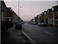
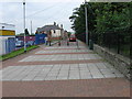
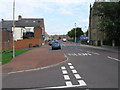
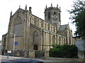
Photos of NE8 4YU


Area Information
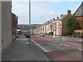
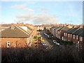
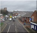
NE8 4YU is a small residential postcode area in England, home to around 1460 people. It is a compact cluster of homes, primarily occupied by adults aged 30–64, with a median age of 47. The area’s character is defined by its proximity to local schools, retail hubs, and transport links. Residents benefit from nearby primary schools, including St Cuthbert’s Church of England Aided Junior School and Derwent Infant School, which cater to younger families. The area is well-connected to rail and metro services, with Dunston Railway Station and Gateshead Central Station within reach. For daily life, residents have access to shops like Tesco Gateshead and Aldi Dunston, alongside bus routes that link to surrounding districts. While the population is modest, the area offers a blend of practical amenities and community-focused infrastructure, making it suitable for those prioritising accessibility over large-scale urban features.
- Area Type
- Postcode
- Area Size
- Not available
- Population
- 1460
- Population Density
- 3950 people/km²
NE8 4YU is a small area with a housing stock primarily composed of houses, reflecting a traditional suburban or semi-rural layout. Home ownership rates are 35%, which is lower than the national average, suggesting a significant proportion of properties are rented. This dynamic positions the area more as a rental market than an owner-occupied one, which may influence property values and availability. The predominance of houses implies fewer high-density developments, appealing to those seeking space and privacy. For buyers, the limited size of the area means competition for properties is likely concentrated among local residents and those prioritising proximity to schools and transport. The mix of ownership and rental properties could offer opportunities for investment, though the small scale of the area may limit broader market trends.
House Prices in NE8 4YU
No properties found in this postcode.
Energy Efficiency in NE8 4YU
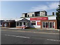
The lifestyle in NE8 4YU is shaped by its proximity to retail, dining, and transport hubs. Nearby shops include Tesco Gateshead, Aldi Dunston, and Heron Durham, providing essential grocery and retail services. The area’s rail and metro links, such as Dunston Railway Station and Gateshead Central Station, facilitate easy access to larger urban centres. While the bus network is limited to a single stop at Rhodes Street, the rail connections compensate with frequent services. For leisure, the area’s small scale means residents often rely on nearby districts for parks and recreational spaces. The mix of retail and transport options supports a practical, community-focused lifestyle, ideal for those valuing convenience without the density of a major city.
Amenities
Schools
NE8 4YU is served by several primary schools, including Derwent Infant School, St Cuthbert’s Church of England Aided Junior School, and St Aidan’s Church of England Primary School. There is also Eslington Primary School, which is designated as a special school. This mix of primary and special educational institutions provides options for families with diverse needs, from general education to tailored support for students with specific requirements. The concentration of schools in the area suggests a focus on local schooling, reducing the need for long commutes. However, the absence of secondary schools nearby may require families to seek options further afield. The presence of multiple primary schools indicates a community-oriented approach to education, with an emphasis on early years and specialist provision.
| Rank | School | Type | Entry gender | Ages |
|---|
Explore more schools in this area
Go to Schools tabDemographics
The community in NE8 4YU is predominantly composed of adults aged 30–64, with a median age of 47. Home ownership stands at 35%, indicating a mix of owner-occupied and rental properties. The area is largely made up of houses, reflecting a traditional housing stock. The predominant ethnic group is White, though specific data on diversity or deprivation is not provided. The age profile suggests a stable population, likely with established families and professionals. With a relatively low proportion of younger residents, the area may cater to those seeking a quieter, settled environment. The absence of detailed diversity statistics means broader demographic trends cannot be fully assessed, but the data highlights a community focused on family-oriented living.
Household Size
Accommodation Type
Tenure
Ethnic Group
Religion
Household Composition
Age
Household Deprivation
NS-SEC
Explore more demographic insights in this area
Go to Demographics tabPlanning
Planning Constraints
- Flood RiskPremium
- Ramsar Wetland SitesPremium
- Area of Outstanding Natural BeautyPremium
- Protected Nature ReservePremium
- Protected WoodlandPremium