Area Overview for NE40 4AX
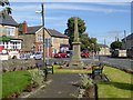
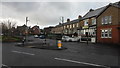
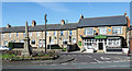
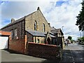
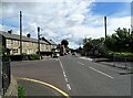
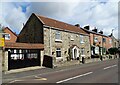
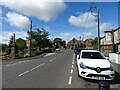
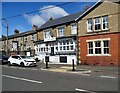
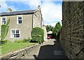
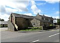
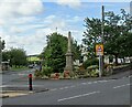
Photos of NE40 4AX

Area Information
Living in NE40 4AX offers a compact, tightly knit residential experience in a small cluster of homes. The area covers 8,835 square metres and is home to 1,986 residents, creating a population density of 906 people per square kilometre. This density suggests a mix of closely spaced housing, likely serving a localised community. The area’s proximity to rail and metro stations, including Wylam and Blaydon, ensures easy access to regional transport networks. While the postcode itself is small, it sits within a broader network of amenities, from retail outlets like Morrisons Daily to educational institutions such as Greenside Primary School. Daily life here is likely characterised by a balance of local convenience and connectivity to larger services. The area’s safety profile, with a crime risk score of 88/100, adds to its appeal for families and professionals seeking a secure environment. NE40 4AX is not a sprawling suburb but a focused residential hub, ideal for those prioritising community cohesion and practical access to essential services.
- Area Type
- Postcode
- Area Size
- 8835 m²
- Population
- 1986
- Population Density
- 906 people/km²
The property market in NE40 4AX is characterised by a high rate of home ownership, with 71% of residents living in owner-occupied homes. This suggests a market where long-term residency and investment are common, rather than a rental-dominated area. The accommodation type is predominantly houses, which may reflect a preference for standalone properties over flats or apartments. Given the small area size of 8,835 square metres, the housing stock is likely limited, with properties concentrated in a compact cluster. Buyers considering NE40 4AX should note that the immediate surroundings may offer more options, but the postcode itself is unlikely to have a large inventory of homes. The focus on houses also implies that properties here may be larger or more traditional in design, appealing to those seeking space and privacy. For first-time buyers, the market may be competitive, with limited availability and a need to look beyond the postcode for broader choices.
House Prices in NE40 4AX
Showing 7 properties
| Address | Type | Beds | Baths | Last Sale Price | Last Sale Date | |
|---|---|---|---|---|---|---|
| Claremont House, Rockwood Hill Road, Greenside, Ryton, NE40 4AX | house | 3 | - | £118,000 | Jan 2012 | |
| Orchard View, Rockwood Hill Road, Greenside, Ryton, NE40 4AX | Terraced | - | - | £60,000 | May 1999 | |
| Argyle House, Rockwood Hill Road, Greenside, Ryton, NE40 4AX | Terraced | - | - | - | - | |
| W Wishart And Son Butcher, Argylle House, Rockwood Hill Road, Greenside, Ryton, NE40 4AX | shop | - | - | - | - | |
| Grayden House, Rockwood Hill Road, Greenside, Ryton, NE40 4AX | Terraced | - | - | - | - | |
| Hillside, Rockwood Hill Road, Greenside, Ryton, NE40 4AX | Detached | - | - | - | - | |
| Greenside Primary School, Rockwood Hill Road, Greenside, Ryton, NE40 4AX | commercial | - | - | - | - |
Energy Efficiency in NE40 4AX
The lifestyle in NE40 4AX is shaped by its proximity to essential amenities, including retail outlets like Morrisons Daily and Co-op Crawcrook. These stores offer everyday shopping convenience, from groceries to household items. The area’s rail and metro links, such as Wylam Station and Callerton Parkway, provide access to broader leisure and employment opportunities beyond the immediate postcode. While the data does not list parks or recreational facilities, the presence of multiple retail and transport options suggests a focus on practicality over expansive green spaces. Residents can enjoy a mix of local shopping and efficient travel, making daily routines efficient. The small area’s character is defined by its compactness, where amenities are within walking or short driving distance. This balance of convenience and connectivity supports a lifestyle that prioritises accessibility without sacrificing the benefits of a residential community.
Amenities
Schools
The nearest school to NE40 4AX is Greenside Primary School, which holds an outstanding Ofsted rating. This indicates a high standard of education for younger children, which is a significant draw for families with school-age dependents. The presence of a primary school within practical reach suggests that the area is well-served for early education, reducing the need for long commutes. However, no secondary schools are listed in the data, meaning families may need to look further afield for secondary education. The single school listed highlights the importance of Greenside Primary as a central institution for the community. Its outstanding rating implies strong performance in areas such as teaching quality, pupil outcomes, and facilities. For parents prioritising educational excellence, this school is a key factor in assessing the area’s suitability for family living.
| Rank | School | Type | Entry gender | Ages |
|---|
Explore more schools in this area
Go to Schools tabDemographics
The population of NE40 4AX is predominantly adults aged 30–64, with a median age of 47. This suggests a mature, stable community, likely centred around families and professionals in mid-career. Home ownership is high at 71%, with houses being the primary accommodation type. This indicates a largely owner-occupied area, which may reflect long-term residency and investment in property. The predominant ethnic group is White, though no specific data on diversity or deprivation levels is provided. The age profile and ownership figures suggest a community with established roots, where residents may prioritise stability over transient living. With 1,986 people in a small area, social networks are likely tight-knit, fostering a sense of familiarity. The absence of specific deprivation data means the quality of life here remains unquantified, but the demographic profile aligns with areas where services and amenities cater to middle-aged households.
Household Size
Accommodation Type
Tenure
Ethnic Group
Religion
Household Composition
Age
Household Deprivation
NS-SEC
Explore more demographic insights in this area
Go to Demographics tabPlanning
Planning Constraints
- Flood RiskPremium
- Ramsar Wetland SitesPremium
- Area of Outstanding Natural BeautyPremium
- Protected Nature ReservePremium
- Protected WoodlandPremium