Area Overview for NE4 9NH
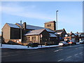
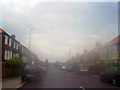
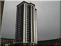
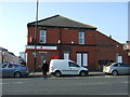
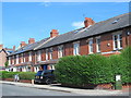
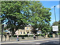
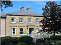
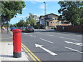
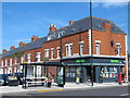
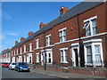
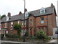
Photos of NE4 9NH

Area Information
NE4 9NH is a compact residential postcode in England, covering just 9,492 square metres and home to 1,736 residents. Its high population density of 182,892 people per square kilometre reflects a tightly knit community, though the area remains small enough to feel intimate. The postcode’s character is shaped by its proximity to retail hubs, transport links, and schools, making it a practical choice for those prioritising convenience. While the median age is 22, the dominant age group is adults aged 30–64, suggesting a mix of young professionals and families. The area’s Asian_total demographic is notable, adding cultural diversity to its social fabric. Daily life here is defined by accessibility—retail options like Tesco Fenham W and Asda Benwell are within reach, while rail and metro stations provide swift connections to Newcastle and beyond. Though modest in size, NE4 9NH offers a blend of practicality and proximity to essential services, appealing to those seeking a manageable, connected living environment.
- Area Type
- Postcode
- Area Size
- 9492 m²
- Population
- 1736
- Population Density
- 10099 people/km²
NE4 9NH is primarily a residential area with a focus on houses, though 49% of homes are owner-occupied, leaving a significant portion of the housing stock in the rental market. The small area size and high population density suggest a limited number of properties, which may mean buyers need to consider nearby zones for more options. The presence of families, as indicated by the 30–64 age demographic, aligns with a demand for stable, long-term housing. However, the compact nature of the postcode could mean that property availability is constrained, particularly for those seeking larger homes or specific features. For buyers, this area’s appeal lies in its proximity to schools, transport, and retail, though the small footprint may require careful consideration of location within the postcode. The balance between owner-occupation and rental properties suggests a dynamic market, but with limited scope for expansion.
House Prices in NE4 9NH
Showing 30 properties
| Address | Type | Beds | Baths | Last Sale Price | Last Sale Date | |
|---|---|---|---|---|---|---|
| 40 Gowland Avenue, Newcastle Upon Tyne, NE4 9NH | Semi-detached | 5 | 1 | £300,000 | Mar 2024 | |
| Ashdale, 8 Gowland Avenue, Newcastle Upon Tyne, NE4 9NH | house | - | - | £185,000 | Feb 2023 | |
| Broomroyd, 14 Gowland Avenue, Newcastle Upon Tyne, NE4 9NH | Semi-detached | 3 | 1 | £158,000 | Nov 2020 | |
| 50 Gowland Avenue, Newcastle Upon Tyne, NE4 9NH | Semi-detached | 6 | 3 | £170,000 | Jul 2020 | |
| 28 Gowland Avenue, Newcastle Upon Tyne, NE4 9NH | Semi-detached | 3 | 2 | £101,100 | May 2018 | |
| Yeovil, 38 Gowland Avenue, Newcastle Upon Tyne, NE4 9NH | Semi-detached | 3 | 2 | £175,000 | Jan 2018 | |
| 42 Gowland Avenue, Newcastle Upon Tyne, NE4 9NH | Semi-detached | 5 | - | £176,000 | Aug 2017 | |
| 10 Gowland Avenue, Newcastle Upon Tyne, NE4 9NH | Semi-detached | 3 | 1 | £153,000 | Aug 2017 | |
| 4 Gowland Avenue, Newcastle Upon Tyne, NE4 9NH | Semi-detached | 8 | 4 | £193,000 | Jun 2014 | |
| 62 Gowland Avenue, Newcastle Upon Tyne, NE4 9NH | Semi-detached | 3 | - | £124,000 | Apr 2014 |
Energy Efficiency in NE4 9NH
Living in NE4 9NH offers access to a range of amenities within walking or short driving distance. Retail options include major chains like Tesco Fenham W, Asda Benwell, and Lidl Benwell, ensuring grocery and daily needs are easily met. The area’s transport links, including Metrocentre Railway Station and Dunston Railway Station, provide swift access to Newcastle’s city centre and beyond. While parks or green spaces are not explicitly mentioned in the data, the absence of protected natural areas suggests that open spaces may be limited. The presence of a bus stop at Rhodes Street and proximity to Newcastle Airport adds to the area’s practicality. For leisure, the mix of retail and transport hubs implies a focus on convenience over expansive recreational facilities. The compact nature of the postcode means amenities are closely clustered, which can be both a benefit and a limitation depending on individual preferences. Overall, the lifestyle here is defined by accessibility and proximity to essential services.
Amenities
Schools
Residents of NE4 9NH have access to two primary schools: Wingrove Primary School, rated ‘good’ by Ofsted, and Wingrove Infant School. Both institutions cater to younger children, providing a foundation for early education. The absence of secondary schools in the data means families may need to look beyond the immediate area for secondary education. The presence of two primary schools within the postcode suggests a focus on early learning, which could be beneficial for families with young children. However, the lack of higher-level educational facilities nearby may be a consideration for those planning long-term stays. The ‘good’ rating at Wingrove Primary indicates a standard of teaching that meets expectations, though no further details on curriculum or facilities are provided. For parents, the availability of primary schools is a clear advantage, but secondary education options remain a practical concern.
| Rank | School | Type | Entry gender | Ages |
|---|
Explore more schools in this area
Go to Schools tabDemographics
The population of NE4 9NH skews toward adults aged 30–64, despite a median age of 22. This suggests a community where younger residents are often accompanied by older family members or professionals. Home ownership rates stand at 49%, indicating a balanced mix of owner-occupied properties and rentals. The area is predominantly composed of houses, which contrasts with higher-density housing typologies. The predominant ethnic group is Asian_total, reflecting a distinct cultural presence. With 1,736 residents in a small area, the community is tightly knit, though the high population density of 182,892 people per square kilometre may influence the pace of life. This density, while potentially limiting green space, ensures that amenities and services are closely clustered. The data does not indicate deprivation levels, but the mix of age groups and ownership types suggests a diverse, functional neighbourhood where families and individuals coexist.
Household Size
Accommodation Type
Tenure
Ethnic Group
Religion
Household Composition
Age
Household Deprivation
NS-SEC
Explore more demographic insights in this area
Go to Demographics tabPlanning
Planning Constraints
- Flood RiskPremium
- Ramsar Wetland SitesPremium
- Area of Outstanding Natural BeautyPremium
- Protected Nature ReservePremium
- Protected WoodlandPremium