Area Overview for NE29 7XN
Photos of NE29 7XN


Area Information
Living in NE29 7XN means inhabiting a tightly knit residential cluster in England, where 1,431 people reside across a compact area. With a population density of 1,030 people per square kilometre, this postcode reflects a mature community, with a median age of 47 and a majority of residents aged 30–64. The area’s character is defined by its housing stock, which is predominantly owner-occupied, and its proximity to essential services. Daily life here is shaped by the mix of retail, transport, and educational hubs nearby. While the population is relatively small, the area’s connectivity to Newcastle, South Shields, and surrounding towns via rail, ferry, and metro ensures easy access to urban amenities. The presence of two well-rated primary schools and a range of local shops and transport links suggests a practical, family-friendly environment. However, the area’s compact nature means it is best suited for those prioritising convenience over expansive space, with a focus on proximity to key services and a stable, adult-oriented community.
- Area Type
- Postcode
- Area Size
- Not available
- Population
- 1431
- Population Density
- 1030 people/km²
The property market in NE29 7XN is dominated by owner-occupied homes, with 52% of properties in private hands. This suggests a community of long-term residents rather than a rental-heavy market. The accommodation type is primarily houses, which is unusual for areas with high population density but aligns with the postcode’s compact, residential nature. Given the small size of the area, the housing stock is likely limited, making it a niche market for buyers seeking a specific location. The focus on houses may appeal to those prioritising space and privacy, though the proximity to urban centres like Newcastle could also attract commuters. Buyers should consider the limited availability of properties and the potential for competition among local residents. The area’s stability, combined with its transport links, may make it an attractive option for those seeking a balance between suburban living and city access.
House Prices in NE29 7XN
No properties found in this postcode.
Energy Efficiency in NE29 7XN
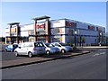
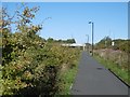
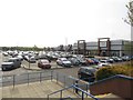
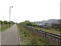
Daily life in NE29 7XN is shaped by its proximity to a range of amenities. Local retail options include Tesco North, M&S Silverlink, and Iceland North, offering essential shopping and dining. The area’s transport links to Percy Main, Howdon, and Meadow Well metro stations, as well as rail stops like Brockley Whins and Heworth, ensure easy access to urban centres. For those seeking leisure, the nearby Newcastle International Ferry Terminal and South Shields Ferry Terminal provide connections to coastal destinations. The mix of retail, transport, and waterfront access creates a practical lifestyle, though the area’s small size means it relies on nearby towns for more extensive services. The availability of multiple transport options and local shops suggests a community that values convenience and accessibility.
Amenities
Schools
Residents of NE29 7XN have access to two primary schools, both rated ‘good’ by Ofsted: Collingwood Primary School and Norham High School. While both are primary institutions, their presence suggests a focus on early education within the area. The absence of secondary schools nearby means families may need to travel to nearby towns for high school education. The availability of two primary schools with strong ratings is a positive for families with young children, though the lack of secondary options could be a drawback. The schools’ proximity to residential areas indicates an intentional design to support local families, though the need for additional educational infrastructure beyond primary level is evident.
| Rank | School | Type | Entry gender | Ages |
|---|
Explore more schools in this area
Go to Schools tabDemographics
The community in NE29 7XN is predominantly composed of adults aged 30–64, reflecting a mature demographic profile with a median age of 47. Home ownership stands at 52%, indicating a mix of long-term residents and those seeking stable housing. The area is characterised by a predominance of houses rather than flats, suggesting a focus on family-oriented living. The predominant ethnic group is White, with no specific data provided on other demographics. The age range and home ownership figures imply a community that is largely established, with fewer young families or transient populations. This profile may influence local services and amenities, which cater to adult needs rather than those of children or elderly residents. The absence of detailed diversity data means the area’s cultural composition remains less defined, but the demographic stability suggests a low turnover of residents.
Household Size
Accommodation Type
Tenure
Ethnic Group
Religion
Household Composition
Age
Household Deprivation
NS-SEC
Explore more demographic insights in this area
Go to Demographics tabPlanning
Planning Constraints
- Flood RiskPremium
- Ramsar Wetland SitesPremium
- Area of Outstanding Natural BeautyPremium
- Protected Nature ReservePremium
- Protected WoodlandPremium