Area Overview for NE29 7TD
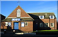
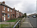
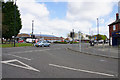
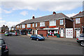
Photos of NE29 7TD


Area Information
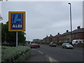
NE29 7TD is a compact residential postcode in England, home to 1,431 people spread across a densely populated area of 1.39 km². This small cluster of homes sits at the heart of a community defined by its proximity to transport networks and local amenities. The area’s population density of 1,030 people per square kilometre suggests a tightly knit neighbourhood, where daily life is shaped by the rhythm of nearby metro stations, rail lines, and ferry terminals. While the postcode is small, it offers access to a range of practical services, from supermarkets to schools, making it a viable option for those seeking convenience without sacrificing space. The presence of multiple retail outlets, including Spar and Aldi, alongside transport hubs like Percy Main and Howdon, underscores the area’s connectivity. For buyers, NE29 7TD represents a balance between urban accessibility and the quietude of a residential cluster, though its limited size means the surrounding areas are key to understanding its full appeal.
- Area Type
- Postcode
- Area Size
- Not available
- Population
- 1431
- Population Density
- 1030 people/km²
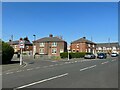
NE29 7TD is primarily a home-owning area, with 52% of residents owning their properties. The housing stock is dominated by houses, which aligns with the community’s demographic profile of middle-aged adults and families. This suggests a market skewed towards owner-occupation rather than rentals, though the relatively low home ownership rate implies some properties may be available for purchase or let. The concentration of houses, as opposed to flats, indicates a focus on traditional family homes, which could appeal to buyers seeking space and privacy. However, the small size of the postcode means the immediate surroundings are critical to understanding the full range of housing options. Buyers should consider nearby areas for a broader selection, though the current stock in NE29 7TD offers a straightforward, if limited, choice.
House Prices in NE29 7TD
No properties found in this postcode.
Energy Efficiency in NE29 7TD
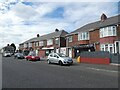
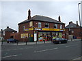
Daily life in NE29 7TD is shaped by its proximity to retail, transport, and leisure options. The area is served by five retail outlets, including Spar and Aldi, offering convenience for groceries and essentials. Metro stations, rail lines, and ferry terminals provide easy access to nearby towns and cities, while bus routes add local mobility. Though the postcode itself is small, the surrounding areas host parks and open spaces, though specific names are not listed. The presence of multiple transport hubs and retail choices suggests a practical, functional lifestyle, ideal for those prioritising accessibility over expansive recreational facilities. For residents, the balance of services and connectivity makes NE29 7TD a practical base, though larger-scale amenities may require venturing beyond the immediate vicinity.
Amenities
Schools
Residents of NE29 7TD have access to two primary schools: Collingwood Primary School and Norham High School, both of which hold a ‘good’ Ofsted rating. While both are categorised as primary schools, their coexistence suggests a concentration of early education options within the area. This is beneficial for families with young children, as it reduces the need for long commutes to secondary education. However, the absence of secondary schools in the immediate vicinity means parents may need to look further afield for high school placements. The quality of the primary schools, combined with the area’s transport links, positions NE29 7TD as a viable option for families prioritising early education but requiring additional planning for secondary schooling.
| Rank | School | Type | Entry gender | Ages |
|---|
Explore more schools in this area
Go to Schools tabDemographics
The residents of NE29 7TD are predominantly adults aged 30–64, with a median age of 47. This suggests a community of middle-aged individuals, many of whom may be in their prime working years or raising families. Home ownership stands at 52%, indicating a mix of owner-occupied properties and rental units. The area is characterised by houses rather than flats, reflecting a preference for family homes. The predominant ethnic group is White, with no specific data on other demographics provided. The age profile and housing stock suggest a stable, long-term resident base, though the lack of younger households may influence local services and amenities. The absence of detailed deprivation data means quality of life factors such as access to healthcare or leisure cannot be assessed here, but the presence of schools and transport links hints at a functional, if modest, infrastructure.
Household Size
Accommodation Type
Tenure
Ethnic Group
Religion
Household Composition
Age
Household Deprivation
NS-SEC
Explore more demographic insights in this area
Go to Demographics tabPlanning
Planning Constraints
- Flood RiskPremium
- Ramsar Wetland SitesPremium
- Area of Outstanding Natural BeautyPremium
- Protected Nature ReservePremium
- Protected WoodlandPremium