Area Overview for NE29 7SL
Photos of NE29 7SL


Area Information
Living in NE29 7SL means inhabiting a tightly knit residential cluster in northeast England, where 1,431 people reside across a compact area. With a population density of 1,030 people per square kilometre, the community feels close-knit, with homes predominantly in private ownership. The area’s character is shaped by its mature demographic, with a median age of 47 and most residents falling between 30 and 64 years old. Daily life here balances quiet residential living with proximity to essential services. The postcode’s small footprint means amenities are within practical reach, from schools to transport hubs. While the area lacks large-scale infrastructure, its accessibility to nearby towns and cities via rail, bus, and ferry routes offers flexibility. For those seeking a stable, low-flood-risk environment, NE29 7SL provides a base with minimal environmental constraints. However, the community’s safety profile demands attention, as crime rates are above average. This postcode is ideal for those prioritising convenience and a settled lifestyle, though vigilance is advised.
- Area Type
- Postcode
- Area Size
- Not available
- Population
- 1431
- Population Density
- 1030 people/km²
The property market in NE29 7SL is characterised by a 52% home ownership rate, with houses forming the dominant accommodation type. This suggests a market skewed towards owner-occupied homes rather than rental properties, indicating a stable, long-term resident base. The small postcode area likely features a limited number of properties, making it a niche market for buyers seeking specific homes. The prevalence of houses may appeal to families or those preferring larger living spaces, though the compact nature of the area means housing options are not extensive. For buyers, this implies a need to act swiftly when opportunities arise, as inventory is constrained. The market’s reliance on private ownership also suggests lower turnover, with properties potentially retaining value over time. However, the lack of data on property prices or recent sales trends means the financial dynamics remain opaque.
House Prices in NE29 7SL
No properties found in this postcode.
Energy Efficiency in NE29 7SL
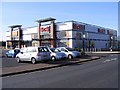
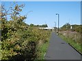
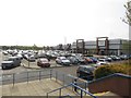
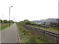
The lifestyle in NE29 7SL is shaped by its proximity to a variety of amenities. Retail options include five shops, such as Tesco North and Iceland North, alongside M&S Silverlink, offering everyday essentials. Metro stations like Percy Main and Howdon provide easy access to public transport, while rail links to Railway Station and Heworth ensure connectivity to larger towns. Ferries at Newcastle International Terminal and South Shields offer water-based travel options. The area’s five rail stations and one bus route create a web of transport choices, supporting both commuting and leisure travel. For residents, this mix of retail, transport, and mobility options fosters convenience, allowing daily errands and trips to be managed efficiently. The presence of multiple transport hubs also suggests the area is strategically positioned for those needing to travel beyond its small bounds.
Amenities
Schools
Residents of NE29 7SL have access to two primary schools: Collingwood Primary School and Norham High School, both rated ‘good’ by Ofsted. While both institutions are primary schools, their presence indicates a focus on early education, which is beneficial for families with young children. The absence of secondary schools in the immediate area means students may need to commute to nearby towns for higher education. However, the quality ratings suggest a solid foundation for primary learning. The concentration of primary schools supports a community-oriented approach to education, though parents should consider secondary schooling options beyond the postcode. For those prioritising strong early education, NE29 7SL offers reliable, locally rated institutions.
| Rank | School | Type | Entry gender | Ages |
|---|
Explore more schools in this area
Go to Schools tabDemographics
NE29 7SL’s population is predominantly composed of adults aged 30 to 64, reflecting a mature, established community. The median age of 47 indicates a demographic skewed towards middle-aged residents, with fewer younger or elderly households. Home ownership here stands at 52%, suggesting a mix of owner-occupied properties and rental units. The accommodation type is primarily houses, which may imply a preference for family homes or larger living spaces. The predominant ethnic group is White, with no data provided on other demographics. This profile suggests a community with strong local ties and a focus on stability. However, the absence of specific data on deprivation or diversity means the area’s socioeconomic breadth remains unclear. For families, the age distribution aligns with those raising children, though the lack of detailed diversity metrics limits understanding of broader social dynamics.
Household Size
Accommodation Type
Tenure
Ethnic Group
Religion
Household Composition
Age
Household Deprivation
NS-SEC
Explore more demographic insights in this area
Go to Demographics tabPlanning
Planning Constraints
- Flood RiskPremium
- Ramsar Wetland SitesPremium
- Area of Outstanding Natural BeautyPremium
- Protected Nature ReservePremium
- Protected WoodlandPremium