Area Overview for NE29 6EE
Photos of NE29 6EE


Area Information
Living in NE29 6EE means inhabiting a compact, residential postcode area in England, spanning 16.5 hectares and home to 1,551 people. With a population density of 1,144 people per square kilometre, this is a tightly knit community where proximity to amenities and transport links defines daily life. The area’s character is shaped by its mix of houses, a high rate of home ownership (66%), and a predominantly White population. Residents here are largely adults aged 30–64, reflecting a mature demographic that values stability and local connections. The postcode’s small size means residents are within easy reach of nearby towns and services, though the area itself remains focused on residential living. With broadband rated excellent (98/100) and mobile coverage good (85/100), digital connectivity supports both work and leisure. However, the area’s compact nature means it is not a hub for large-scale retail or leisure, with essential services and transport options requiring a short journey. For those prioritising a quiet, community-oriented lifestyle with practical access to regional hubs, NE29 6EE offers a blend of residential comfort and functional connectivity.
- Area Type
- Postcode
- Area Size
- 16.5 hectares
- Population
- 1551
- Population Density
- 1144 people/km²
The property market in NE29 6EE is characterised by a high rate of home ownership (66%), with houses forming the predominant accommodation type. This suggests a market skewed towards owner-occupied properties rather than rental units, which may appeal to buyers seeking long-term investment or family homes. The small area size (16.5 hectares) means the housing stock is limited, likely comprising a mix of semi-detached, terraced, or detached homes. Given the mature demographic of residents (median age 47), properties here may cater to those looking for established, low-maintenance homes rather than new-build developments. The compact nature of the area means buyers should consider the surrounding regions for additional housing options, though the immediate vicinity offers a cohesive residential environment. For those prioritising ownership over renting, NE29 6EE presents a stable market, but its small size may limit choice. Potential buyers should also note the area’s proximity to transport links, which could enhance the value of properties with access to regional hubs.
House Prices in NE29 6EE
Showing 3 properties
| Address | Type | Beds | Baths | Last Sale Price | Last Sale Date | |
|---|---|---|---|---|---|---|
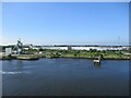
| Dfds, Transit Shed, Coble Dene, North Shields, NE29 6EE | commercial | - | - | - | - | |
| Bcp, Border Control Post, Coble Dene, North Shields, NE29 6EE | storage_distribution | - | - | - | - | |
| Port Of Tyne Authority, Lorry Park, Coble Dene, North Shields, NE29 6EE | passenger_terminal | - | - | - | - |
Energy Efficiency in NE29 6EE
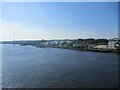
Residents of NE29 6EE have access to a range of amenities within practical reach, including retail, transport, and leisure options. The area’s proximity to supermarkets such as Heron Frederick, Lidl Central South, and Asda South ensures everyday shopping needs are met. Ferry services at Newcastle International Ferry Terminal and South Shields Ferry Terminal provide direct links to coastal and urban destinations, while rail and metro stations like Meadow Well, Percy Main, and Chichester offer regional connectivity. The presence of multiple bus routes, including the Rhodes Street stop, enhances local mobility. Though the area is small, its integration with nearby towns means residents can access broader leisure and cultural opportunities. The mix of retail, transport, and transport links creates a functional lifestyle, where daily needs are met without the need for long commutes. This balance of accessibility and quiet residential living makes NE29 6EE suitable for those who value convenience without sacrificing a sense of community.
Amenities
Schools
| Rank | School | Type | Entry gender | Ages |
|---|
Explore more schools in this area
Go to Schools tabDemographics
NE29 6EE has a median age of 47, with the majority of residents falling within the 30–64 age range. This reflects a community of established adults, many of whom are likely to be in their prime working years or nearing retirement. Home ownership is strong, with 66% of properties owned by residents, indicating a preference for long-term stability over rental living. The accommodation type is predominantly houses, suggesting a focus on family homes or larger properties. The predominant ethnic group is White, though no specific data on diversity or minority populations is provided. The population density of 1,144 people per square kilometre means the area is neither sprawling nor overcrowded, offering a balance between space and community interaction. While no deprivation data is available, the high home ownership rate and mature age profile suggest a relatively stable socioeconomic environment. This demographic profile implies a community where local amenities and services are likely to cater to middle-aged and older residents, with a focus on practicality and convenience over youth-centric facilities.
Household Size
Accommodation Type
Tenure
Ethnic Group
Religion
Household Composition
Age
Household Deprivation
NS-SEC
Explore more demographic insights in this area
Go to Demographics tabPlanning
Planning Constraints
- Flood RiskPremium
- Ramsar Wetland SitesPremium
- Area of Outstanding Natural BeautyPremium
- Protected Nature ReservePremium
- Protected WoodlandPremium