Area Overview for NE28 6UX
Photos of NE28 6UX


Area Information
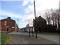
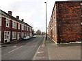
Living in NE28 6UX means being part of a small, tightly knit residential cluster in England, home to 2,513 people. This postcode area is characterised by its modest scale, offering a quiet contrast to larger urban centres. The community is predominantly composed of adults aged 30–64, suggesting a mix of established families and professionals. Daily life here is shaped by proximity to essential amenities, including retail outlets like Morrisons Daily and Iceland Jarrow, as well as transport links to Jarrow, Howdon, and Percy Main. The area’s compact size means residents can access nearby towns and services within short distances, while the broadband score of 94 ensures reliable internet connectivity for remote work or entertainment. Though not a sprawling suburb, NE28 6UX provides a balance of convenience and tranquillity, with no major environmental constraints like protected woodlands or Areas of Outstanding Natural Beauty. However, the medium crime risk score of 36 means residents should remain vigilant about standard security measures. For those seeking a low-maintenance lifestyle with practical infrastructure, this area offers a straightforward, no-frills foundation.
- Area Type
- Postcode
- Area Size
- Not available
- Population
- 2513
- Population Density
- Not available
NE28 6UX is a small area where 51% of properties are owner-occupied, with the remaining 49% likely in the rental market. The accommodation type is predominantly houses, indicating a focus on single-family homes rather than apartments or flats. This suggests a community of established residents, many of whom may have lived in the area for years. The limited size of the postcode means the housing stock is constrained, and buyers may need to look beyond the immediate area for more options. The mix of owner-occupied and rental properties implies a moderate turnover, but the lack of specific data on property prices or trends means the market remains opaque. For those seeking a home, the presence of houses offers practical living spaces, but the small scale of the area means competition could be fierce. Buyers should also consider nearby postcode areas for broader choices, particularly if seeking newer builds or larger properties.
House Prices in NE28 6UX
No properties found in this postcode.
Energy Efficiency in NE28 6UX
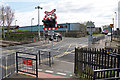
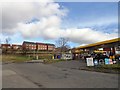
Daily life in NE28 6UX is shaped by its proximity to essential amenities, including five retail outlets such as Morrisons Daily and Iceland Jarrow, which provide grocery and household essentials. The area’s transport links to Jarrow, Howdon, and Percy Main make it easy to access larger towns for more specialised shopping or dining. Residents can also reach ferry terminals at Newcastle International and South Shields, offering water-based travel options. The five railway stations in the vicinity connect to broader networks, enabling quick access to cities like Newcastle. For leisure, the absence of major parks or recreational facilities within the postcode means residents may need to travel to nearby areas, though the presence of multiple transport options mitigates this. The mix of retail, transport, and connectivity ensures a practical lifestyle, with the area’s small size encouraging a focus on nearby hubs for social and cultural activities.
Amenities
Schools
The nearest school to NE28 6UX is Stephenson Memorial Middle School, a primary institution serving the local community. While no Ofsted rating is provided, the presence of a primary school suggests the area is suitable for families with young children. However, the absence of secondary schools or additional educational institutions within the immediate vicinity means parents may need to look to nearby towns like Jarrow or South Shields for comprehensive schooling. The single primary school available indicates a modest educational infrastructure, which could be a consideration for families requiring multiple school options. Given the area’s small size, the school likely serves a broader surrounding region, making it a central point for local education. For those prioritising proximity to schools, the availability of a primary institution is a practical advantage, though secondary education may require commuting.
| Rank | School | Type | Entry gender | Ages |
|---|
Explore more schools in this area
Go to Schools tabDemographics
The population of NE28 6UX is 2,513, with a median age of 47, indicating a mature demographic skewed toward adults aged 30–64. This age range suggests a community of long-term residents, many of whom may be raising families or working in local industries. Home ownership stands at 51%, meaning nearly half of properties are owner-occupied, while the remaining 49% are likely rented. The predominant accommodation type is houses, reflecting a residential character that prioritises private living spaces over flats. The predominant ethnic group is White, though no specific data on diversity or deprivation levels is provided. The age profile implies a stable, middle-aged population with established routines, though the lack of younger residents may affect local amenities catering to children. The home ownership rate suggests a mix of long-term residents and renters, but the small area size means the housing stock is limited, with buyers needing to consider nearby zones for more options.
Household Size
Accommodation Type
Tenure
Ethnic Group
Religion
Household Composition
Age
Household Deprivation
NS-SEC
Explore more demographic insights in this area
Go to Demographics tabPlanning
Planning Constraints
- Flood RiskPremium
- Ramsar Wetland SitesPremium
- Area of Outstanding Natural BeautyPremium
- Protected Nature ReservePremium
- Protected WoodlandPremium
- Crime & SafetyPremium