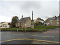
Area Overview for NE11 9NL
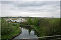
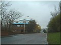
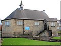
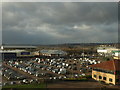
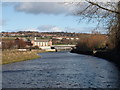
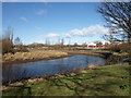
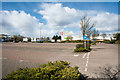
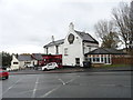
Photos of NE11 9NL


Area Information
NE11 9NL is a compact residential cluster in England, home to 1,569 people spread across a densely populated area. With a population density of 860 people per square kilometre, this postcode reflects a tight-knit community where daily life is shaped by proximity to local amenities and transport links. The area is characterised by a mature demographic, with a median age of 47 and most residents falling within the 30–64 age range. This suggests a stable, established population, many of whom are likely long-term residents. The presence of 49% home ownership indicates a mix of owner-occupied properties and rental units, though the exact balance is unclear. Despite its small size, NE11 9NL offers practical access to retail, rail, and metro services, making it a functional base for commuters and families. Its location near major transport hubs, including the Metrocentre Railway Station and Newcastle Airport, adds to its appeal for those prioritising connectivity. However, the area’s limited size means it is not suited to those seeking expansive living spaces, though its density supports a vibrant, community-focused lifestyle.
- Area Type
- Postcode
- Area Size
- Not available
- Population
- 1569
- Population Density
- 860 people/km²
The property market in NE11 9NL is defined by a 49% home ownership rate, suggesting that nearly half of the area’s residents rent their homes. This implies a dynamic mix of owner-occupied and rental properties, though the exact proportion of each is not specified. The predominant accommodation type is houses, which is notable in a high-density postcode. This combination may indicate a range of property sizes, from smaller family homes to larger residences. Given the area’s compact size, the housing stock is likely limited, which could mean competition for available properties. Buyers should consider the small footprint of NE11 9NL, as its immediate surroundings may offer more options. The presence of houses rather than flats or apartments may appeal to those seeking single-family homes, though the high population density suggests proximity to neighbours. For investors, the balance between rental demand and ownership could influence property values, but the small area size may limit long-term growth potential.
House Prices in NE11 9NL
No properties found in this postcode.
Energy Efficiency in NE11 9NL
Residents of NE11 9NL have access to a range of amenities within practical reach, including five retail outlets such as Asda Gateshead, Lidl Whickham, and Aldi Whickham. These shops provide everyday essentials, supporting a convenient lifestyle. The area’s transport links, including five railway stations and three metro stops, facilitate easy travel to nearby towns and cities, making it ideal for commuters. The presence of Newcastle Airport nearby adds to the area’s appeal for those requiring frequent travel. While the data does not specify parks or leisure facilities, the proximity to transport hubs suggests a focus on connectivity over green spaces. The combination of retail options and transport infrastructure means daily errands and commutes are efficient, though the area’s compact nature may limit opportunities for outdoor recreation. For those prioritising accessibility and practicality, NE11 9NL offers a functional base with minimal need for long journeys to essential services.
Amenities
Schools
| Rank | School | Type | Entry gender | Ages |
|---|
Explore more schools in this area
Go to Schools tabDemographics
The population of NE11 9NL is predominantly adults aged 30–64, with a median age of 47. This suggests a community of middle-aged residents, likely settled in careers and family life. Home ownership stands at 49%, indicating a balanced mix of owner-occupied and rental properties. The accommodation type is primarily houses, which is unusual for a densely populated area, hinting at a mix of larger properties and smaller homes. The predominant ethnic group is White, though specific diversity statistics are not provided. The absence of data on deprivation or socioeconomic status means the area’s quality of life cannot be fully assessed, but the high population density and mature age profile suggest a stable, possibly middle-class demographic. The lack of protected natural areas or planning constraints may contribute to a practical, low-maintenance lifestyle. However, the high crime risk, noted in the assessments, raises concerns about safety, which could impact daily life and property desirability.
Household Size
Accommodation Type
Tenure
Ethnic Group
Religion
Household Composition
Age
Household Deprivation
NS-SEC
Explore more demographic insights in this area
Go to Demographics tabPlanning
Planning Constraints
- Flood RiskPremium
- Ramsar Wetland SitesPremium
- Area of Outstanding Natural BeautyPremium
- Protected Nature ReservePremium
- Protected WoodlandPremium