Area Overview for NE11 9JX
Photos of NE11 9JX
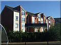
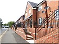
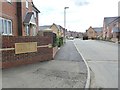
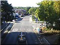

41 photos from this area
Area Information
Key information about the NE11 9JX including its size, population, and administrative classification.
- Area Type
- Postcode
- Area Size
- 7790 m²
- Population
- 2018
- Population Density
- 687 people/km²
House Prices in NE11 9JX
26
Properties
£103,150
Average Sold Price
£80,000
Lowest Price
£115,000
Highest Price
Showing 26 properties
| Address | Type | Beds | Baths | Last Sale Price | Last Sale Date | |
|---|---|---|---|---|---|---|
| 51 Chiltern Gardens, Lobley Hill, Gateshead, NE11 9JX | Semi-detached | 3 | 1 | £115,000 | Jun 2021 | |
| 37 Chiltern Gardens, Lobley Hill, Gateshead, NE11 9JX | Terraced | 3 | 1 | £83,500 | Jun 2018 | |
| 42 Chiltern Gardens, Lobley Hill, Gateshead, NE11 9JX | house | - | - | £105,000 | Jul 2017 | |
| 59 Chiltern Gardens, Lobley Hill, Gateshead, NE11 9JX | Terraced | 3 | 1 | £110,000 | Dec 2015 | |
| 39 Chiltern Gardens, Lobley Hill, Gateshead, NE11 9JX | house | - | - | £109,000 | Jan 2013 | |
| 40 Chiltern Gardens, Lobley Hill, Gateshead, NE11 9JX | Semi-detached | - | - | £110,000 | Jul 2007 | |
| 61 Chiltern Gardens, Lobley Hill, Gateshead, NE11 9JX | Semi-detached | - | - | £100,000 | Mar 2006 | |
| 48 Chiltern Gardens, Lobley Hill, Gateshead, NE11 9JX | house | - | - | £114,000 | Sep 2005 | |
| 47 Chiltern Gardens, Lobley Hill, Gateshead, NE11 9JX | Semi-detached | - | - | £105,000 | Jun 2005 | |
| 38 Chiltern Gardens, Lobley Hill, Gateshead, NE11 9JX | house | - | - | £80,000 | Apr 2005 |
Page 1 of 3
Energy Efficiency in NE11 9JX
Amenities
Schools
| Rank | School | Type | Entry gender | Ages |
|---|
Explore more schools in this area
Go to Schools tabDemographics
Household Size
One person
most common
Accommodation Type
Houses
most common
Tenure
34
majority
Ethnic Group
White
most common
Religion
N/A
most common
Household Composition
N/A
most common
Age
47
median
Adults (30-64 years)
most common
Household Deprivation
N/A
with no deprivation
NS-SEC
20
in Lower managerial occupations
Explore more demographic insights in this area
Go to Demographics tabPlanning
Planning Constraints
- Flood RiskPremium
- Ramsar Wetland SitesPremium
- Area of Outstanding Natural BeautyPremium
- Protected Nature ReservePremium
- Protected WoodlandPremium