Area Overview for NE10 8JR
Photos of NE10 8JR


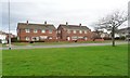

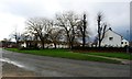


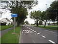

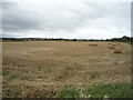
23 photos from this area
Area Information
Key information about the NE10 8JR including its size, population, and administrative classification.
- Area Type
- Postcode
- Area Size
- 1.1 hectares
- Population
- 1405
- Population Density
- 132260 people/km²
House Prices in NE10 8JR
35
Properties
£82,812
Average Sold Price
£32,000
Lowest Price
£140,000
Highest Price
Showing 35 properties
| Address | Type | Beds | Baths | Last Sale Price | Last Sale Date | |
|---|---|---|---|---|---|---|
| 96 Cotemede, Leam Lane Estate, Felling, NE10 8JR | house | 3 | - | £120,000 | Sep 2024 | |
| 70 Cotemede, Leam Lane Estate, Felling, NE10 8JR | Retail | 3 | 1 | £133,100 | Apr 2022 | |
| 88 Cotemede, Leam Lane Estate, Felling, NE10 8JR | house | - | - | £140,000 | Aug 2021 | |
| 62 Cotemede, Leam Lane Estate, Felling, NE10 8JR | Terraced | 3 | - | £91,500 | Nov 2019 | |
| 60 Cotemede, Leam Lane Estate, Felling, NE10 8JR | house | - | - | £80,000 | Apr 2017 | |
| 82 Cotemede, Leam Lane Estate, Felling, NE10 8JR | house | - | - | £62,500 | Nov 2016 | |
| 100 Cotemede, Leam Lane Estate, Felling, NE10 8JR | Semi-detached | 3 | 1 | £71,500 | Apr 2012 | |
| 64 Cotemede, Leam Lane Estate, Felling, NE10 8JR | house | - | - | £95,000 | Dec 2006 | |
| 90 Cotemede, Leam Lane Estate, Felling, NE10 8JR | Semi-detached | - | - | £104,950 | Nov 2006 | |
| 50 Cotemede, Leam Lane Estate, Felling, NE10 8JR | Semi-detached | - | - | £77,000 | Nov 2005 |
Page 1 of 4
Energy Efficiency in NE10 8JR
Amenities
Schools
| Rank | School | Type | Entry gender | Ages |
|---|
Explore more schools in this area
Go to Schools tabDemographics
Household Size
N/A
most common
Accommodation Type
N/A
most common
Tenure
N/A
majority
Ethnic Group
N/A
most common
Religion
N/A
most common
Household Composition
N/A
most common
Age
N/A
median
N/A
most common
Household Deprivation
N/A
with no deprivation
NS-SEC
N/A
in Lower managerial occupations
Explore more demographic insights in this area
Go to Demographics tabPlanning
Planning Constraints
- Flood RiskPremium
- Ramsar Wetland SitesPremium
- Area of Outstanding Natural BeautyPremium
- Protected Nature ReservePremium
- Protected WoodlandPremium