Area Overview for NE1 5DH
Photos of NE1 5DH


Area Information
Living in NE1 5DH means inhabiting a compact residential cluster in England, where 2061 people reside across 2412 square metres. This high population density of 854,618 people per square kilometre reflects a tightly packed community, typical of urban or semi-urban settings. The area is defined by its proximity to transport hubs, retail centres, and educational institutions, making it a practical choice for those prioritising connectivity. Young adults aged 15–29 dominate the demographic, suggesting a dynamic, student-oriented or early-career population. Daily life here is shaped by the availability of nearby amenities, from rail stations to supermarkets, though the small area size means residents are likely to interact with the same local services repeatedly. The presence of secondary schools and multiple transport options indicates a focus on accessibility, though the high population density may influence the pace of life. For buyers, NE1 5DH offers a blend of convenience and proximity, though its limited size means the surrounding areas are critical for broader lifestyle needs.
- Area Type
- Postcode
- Area Size
- 2412 m²
- Population
- Not available
- Population Density
- Not available
The property market in NE1 5DH is characterised by low home ownership, with only 19% of residents owning their homes. The accommodation type is predominantly flats, reflecting a rental market that caters to temporary or short-term occupancy. This suggests the area is more suited to renters than buyers, particularly students or young professionals seeking affordable, flexible housing. The small area size means the housing stock is limited, and the focus on flats may indicate a lack of larger family homes or detached properties. For buyers, this raises questions about long-term investment potential, as the market appears to prioritise rental demand. The proximity to transport hubs and amenities may offset the lack of diverse housing options, but the limited size of NE1 5DH means buyers should consider surrounding areas for broader choices.
House Prices in NE1 5DH
Showing 3 properties
| Address | Type | Beds | Baths | Last Sale Price | Last Sale Date | |
|---|---|---|---|---|---|---|
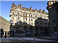
| Royal Station Hotel, Neville Street, Newcastle Upon Tyne, NE1 5DH | hotel | - | - | - | - | |
| Empire Restaurant, Royal Station Hotel, Neville Street, Newcastle Upon Tyne, NE1 5DH | Restaurant | - | - | - | - | |
| Jalou, Royal Station Hotel, Neville Street, Newcastle Upon Tyne, NE1 5DH | retail_financial | - | - | - | - |
Energy Efficiency in NE1 5DH
The lifestyle in NE1 5DH is shaped by its proximity to retail, dining, and transport hubs. Nearby amenities include M&S Newcastle Rail SF, Sainsburys Newcastle, and Heron Newcastle, providing access to shopping, groceries, and dining options. The area’s five metro stations and rail links ensure easy movement to cultural or leisure destinations in Newcastle. While parks or green spaces are not explicitly listed in the data, the presence of transport and retail suggests a focus on urban convenience over natural amenities. The high population density means residents are likely to share public spaces and services, fostering a sense of community but also potential overcrowding. For those valuing accessibility, NE1 5DH offers a compact, well-connected environment, though outdoor recreation may require venturing further afield.
Amenities
Schools
The nearest school to NE1 5DH is North East Futures UTC, a secondary school with an Ofsted rating of satisfactory. This institution serves older students, typically aged 14–18, and focuses on technical and vocational education. The absence of primary schools in the data suggests families may need to look beyond the immediate area for younger children’s education. The single secondary school indicates a limited range of educational options, which could be a consideration for families prioritising school choice. However, the satisfactory Ofsted rating implies the school meets basic standards, though it does not highlight exceptional performance. For residents, this means the area is more suited to those with access to alternative primary education or willingness to commute for younger children’s schooling.
| Rank | School | Type | Entry gender | Ages |
|---|
Explore more schools in this area
Go to Schools tabDemographics
The community in NE1 5DH is predominantly young, with a median age of 22 and 15–29-year-olds making up the most common age range. Only 19% of residents own their homes, with flats being the primary accommodation type. This suggests a rental-heavy market, likely attracting students, young professionals, or those seeking short-term housing. The predominant ethnic group is White, reflecting the broader demographic patterns of the region. The high population density of 854,618 people per square kilometre indicates a compact, possibly overcrowded environment, which may influence the area’s character. While no specific deprivation data is provided, the low home ownership rate and young population could imply a transient community with evolving needs. For residents, this profile means a youthful, active population but also potential challenges in long-term stability or community cohesion.
Household Size
Accommodation Type
Tenure
Ethnic Group
Religion
Household Composition
Age
Household Deprivation
NS-SEC
Explore more demographic insights in this area
Go to Demographics tabPlanning
Planning Constraints
- Flood RiskPremium
- Ramsar Wetland SitesPremium
- Area of Outstanding Natural BeautyPremium
- Protected Nature ReservePremium
- Protected WoodlandPremium