Area Overview for Hemlington Ward
Photos of Hemlington Ward
Area Information
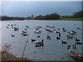
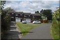
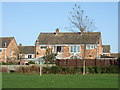
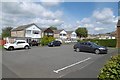
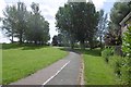
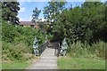
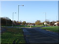
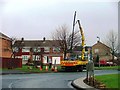
Hemlington Ward represents a distinct residential township situated in the south-western outskirts of Middlesbrough. This district spans just 1.6 km², creating a compact neighbourhood where daily life revolves around its central lake. Historically evolving from rural farmland in the latter half of the 20th century, the area transformed to address housing needs for the growing population of Teesside. Currently located at coordinates 54.52°N, 1.24°W, Hemlington retains its connection to local heritage, including a medieval village site historically centred on a crossroads of Gunnergate Lane and the B1365. Living in Hemlington Ward means experiencing a defined boundary where a single lake acts as the focal point for the community. The area grew separate from the parish of Stainton before being absorbed into the broader borough framework in 1968. Locals enjoy proximity to a former hospital site built in 1895, which once served as an infectious control facility and later treated war injuries. The suburb stands apart from the rest of Middlesbrough through its specific development history and its permanent retention of the central water feature. You can find homes near Hemlington Ward that cater to a population with a significant senior presence. The setting offers a clear separation from industrial zones while maintaining accessibility to the wider borough.
- Area Type
- District Borough Unitary Ward
- Area Size
- 1.6 km²
- Population
- Not available
- Population Density
- Not available
Demographics
The community profile of Hemlington Ward reflects a mature population with a median age of 70 years. This demographic shift indicates that the ward serves primarily older residents who have settled into the area over time. You can expect the majority of households to consist of individuals or couples where age is the dominant factor in household composition. Home ownership stands at 41 per cent, meaning a significant portion of residents rent their homes rather than owning them outright. The remaining 59 per cent of households are likely tenants within public or private rental sectors. Accommodation types in the 1.6 km² area generally suit those with mobility needs or smaller household structures due to the age profile. There is no specific data provided on ethnic diversity or religious affiliation within this specific ward. The population centre around the lake suggests a stable environment where long-term residents form the backbone of local life. Safety considerations for this demographic include crime risk levels that require attention when evaluating living conditions. The age profile means that familiar amenities like local shops become essential for daily life without reliance on extensive car travel.
Household Size
Accommodation Type
Tenure
Ethnic Group
Religion
Household Composition
Age
Household Deprivation
NS-SEC
Explore more demographic insights in this area
Go to Demographics tabPlanning
Planning Constraints
- Flood RiskPremium
- Ramsar Wetland SitesPremium
- Area of Outstanding Natural BeautyPremium
- Protected Nature ReservePremium
- Protected WoodlandPremium
- Crime RiskPremium