Area Overview for DL14 7JG
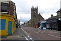
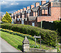
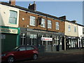
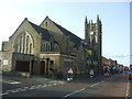
Photos of DL14 7JG
Area Information
Living in DL14 7JG means inhabiting a compact, residential postcode in England with a population of 2,118 people spread across 1.0 hectare. This small area is densely populated, with 1,171 people per square kilometre, reflecting a tight-knit community. The area’s character is defined by its modest scale and proximity to local amenities. Residents here are predominantly adults aged 30–64, with a median age of 47, suggesting a mature, stable demographic. Daily life revolves around nearby retail outlets, rail connections, and schools. The area’s size means it is likely a single neighbourhood rather than a sprawling suburb, fostering a sense of familiarity among residents. While the data does not specify historical context, the presence of multiple rail stations and schools indicates a long-standing role as a residential hub. For buyers, DL14 7JG offers a snapshot of suburban living with limited space but strong local infrastructure. Its small footprint means properties are likely close to each other, and the area’s density may influence both property prices and community dynamics.
- Area Type
- Postcode
- Area Size
- 1.0 hectares
- Population
- 2118
- Population Density
- 1171 people/km²
DL14 7JG is a small area with a housing stock dominated by owner-occupied properties, with 59% of homes owned by their occupants. The accommodation type is primarily houses, which implies a mix of semi-detached or terraced homes typical of smaller residential clusters. Given the area’s size and population density, the property market is likely limited to a handful of listings, with limited scope for new development. Buyers should consider that the high home ownership rate suggests a stable market with fewer rental properties available. The compact nature of DL14 7JG means properties are likely close to each other, with little variation in size or style. For those seeking a home, the area’s proximity to schools, rail stations, and retail amenities may offset its small footprint. However, the lack of data on property prices or recent sales means buyers must rely on local agents for current market insights.
House Prices in DL14 7JG
Showing 1 properties
| Address | Type | Beds | Baths | Last Sale Price | Last Sale Date | |
|---|---|---|---|---|---|---|
| Petrol Station, 6 South Church Road, Bishop Auckland, DL14 7JG | Retail | - | - | - | - |
Energy Efficiency in DL14 7JG
Residents of DL14 7JG have access to five retail outlets, including Asda Bishop, Morrisons Toronto, and Heron Toronto, providing nearby shopping options for groceries and essentials. These stores likely cater to daily needs, reducing the necessity for long trips to larger centres. The area’s rail stations connect to Bishop Auckland and beyond, offering access to broader leisure and employment opportunities. While the data does not specify parks or recreational facilities, the absence of protected natural areas suggests the area is focused on residential and commercial functions. The proximity to schools and shops indicates a lifestyle centred on convenience and community. For families, the mix of retail and rail access supports a balanced routine, though the small area size may limit options for specialist services or entertainment venues.
Amenities
Schools
Near DL14 7JG are two schools: King James I Community Arts College, a primary school, and King James I Academy Bishop Auckland, an academy with a ‘good’ Ofsted rating. The presence of both a primary school and an academy suggests a range of educational options for families. The primary school caters to younger children, while the academy likely offers secondary education. The ‘good’ rating for the academy indicates a satisfactory standard of teaching and facilities, though no specific details on performance metrics are provided. Families in DL14 7JG benefit from having both a local primary school and a secondary institution within reach, reducing the need for long commutes. The mix of school types may appeal to parents seeking a combination of traditional and specialist education. However, the absence of additional schools means families may need to travel further for alternative options.
| Rank | School | Type | Entry gender | Ages |
|---|
Explore more schools in this area
Go to Schools tabDemographics
DL14 7JG’s population is predominantly adults aged 30–64, accounting for the most common age range, with a median age of 47. This suggests a community of middle-aged residents, likely established professionals or families. Home ownership here is strong, with 59% of properties owned by their occupants, compared to 41% rented. The accommodation type is primarily houses, which aligns with the area’s residential character. The predominant ethnic group is White, though the data does not specify further diversity metrics. The population density of 1,171 people per square kilometre indicates a compact, possibly multi-generational living environment. While no explicit deprivation data is provided, the high home ownership rate and stable age profile may correlate with lower deprivation levels, though this remains unconfirmed. The area’s demographic profile suggests a stable, long-term resident base with fewer transient populations.
Household Size
Accommodation Type
Tenure
Ethnic Group
Religion
Household Composition
Age
Household Deprivation
NS-SEC
Explore more demographic insights in this area
Go to Demographics tabPlanning
Planning Constraints
- Flood RiskPremium
- Ramsar Wetland SitesPremium
- Area of Outstanding Natural BeautyPremium
- Protected Nature ReservePremium
- Protected WoodlandPremium