Area Overview for DL1 1PS
Photos of DL1 1PS


Area Information
Living in DL1 1PS means being part of a tightly knit residential cluster in England, where 2,098 people reside across a densely populated area of 1.13 km². This postcode area is characterised by its compact size and high population density of 1,855 people per square kilometre, reflecting a community that is both close-knit and urban. The area is not defined by sprawling suburbs but by a concentration of housing, predominantly flats, which cater to a demographic skewed towards adults aged 30–64. Daily life here is shaped by proximity to amenities, with retail hubs like M&S Darlington WHS and Tesco Cornmill within easy reach. The area’s strategic location near Darlington Railway Station and Durham Tees Valley Airport ensures connectivity to broader regional networks. While the population is predominantly White, the community’s makeup is defined by its home ownership rate of just 24%, suggesting a mix of renters and long-term residents. For those considering DL1 1PS, the balance of convenience and density offers a distinct lifestyle, though the high crime risk noted in assessments demands careful consideration.
- Area Type
- Postcode
- Area Size
- Not available
- Population
- 2098
- Population Density
- 1855 people/km²
The property market in DL1 1PS is defined by its low home ownership rate of 24%, indicating that the majority of housing is rented rather than owned. This suggests a rental market dominated by flats, which are the primary accommodation type in the area. The compact nature of DL1 1PS means that property availability is limited to this small postcode cluster, with little scope for expansion. For buyers, this presents a challenge: the area is not a traditional owner-occupied market but one where long-term renters may dominate. The prevalence of flats also implies a focus on smaller, often multi-unit buildings, which may appeal to those seeking affordability over space. However, the low home ownership rate and limited housing stock mean that buyers should consider the area’s small size and the potential for competition among renters and investors. The immediate surroundings may offer more options, but DL1 1PS itself is a tightly defined market.
House Prices in DL1 1PS
No properties found in this postcode.
Energy Efficiency in DL1 1PS
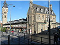
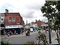
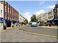
Residents of DL1 1PS have access to a range of nearby amenities, including five retail outlets such as M&S Darlington WHS, Tesco Cornmill, and Sainsburys Darlington. These shops provide everyday essentials, though the absence of larger supermarkets or specialty stores may require trips to nearby areas. The area’s proximity to three railway stations—Darlington, North Road, and Dinsdale—enhances its connectivity, allowing easy access to broader regional amenities. While no parks or leisure facilities are listed in the data, the presence of multiple retail and transport options suggests a lifestyle focused on convenience and accessibility. The compact nature of the area means that residents can reach shops, dining, and transport hubs within short distances, though the lack of green spaces or recreational facilities may be a drawback for those prioritising outdoor activities.
Amenities
Schools
The nearest school to DL1 1PS is Borough Road Nursery School, a nursery providing early education for young children. No primary or secondary schools are listed in the data, which limits the range of educational options available to families. The presence of a nursery suggests that the area caters to younger children, though parents seeking primary or secondary schooling would need to look beyond DL1 1PS. This absence of higher-level schools may impact the appeal of the area for families with older children, requiring additional commuting time or alternative arrangements. The single school listed reflects the small scale of the community, where educational infrastructure is limited to early years provision.
| Rank | School | Type | Entry gender | Ages |
|---|
Explore more schools in this area
Go to Schools tabDemographics
DL1 1PS has a median age of 47, with the majority of residents falling within the 30–64 age range. This suggests a community of established adults, likely with families or long-term careers. Home ownership is low at 24%, indicating that most residents rent their properties, which aligns with the area’s predominant accommodation type: flats. This housing stock implies a focus on smaller, managed living spaces rather than detached homes. The population is predominantly White, with no specific data on other ethnic groups provided. The age profile and housing type suggest a stable, mature demographic, though the absence of data on deprivation or income levels means quality of life factors beyond these metrics remain unexplored. The high proportion of adults in the 30–64 range may reflect a community with established careers and family structures, though further data would be needed to assess the presence of younger or older residents.
Household Size
Accommodation Type
Tenure
Ethnic Group
Religion
Household Composition
Age
Household Deprivation
NS-SEC
Explore more demographic insights in this area
Go to Demographics tabPlanning
Planning Constraints
- Flood RiskPremium
- Ramsar Wetland SitesPremium
- Area of Outstanding Natural BeautyPremium
- Protected Nature ReservePremium
- Protected WoodlandPremium