Area Overview for DH9 8PR
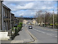
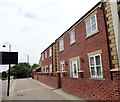
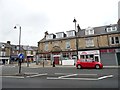
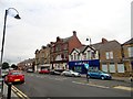
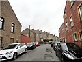
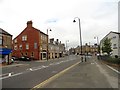
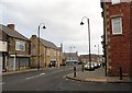
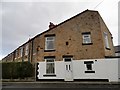
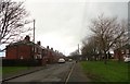
Photos of DH9 8PR


Area Information
Living in DH9 8PR offers a compact, residential experience shaped by its small footprint of 3.7 hectares and a population of 1,678. This postcode area, typical of smaller rural clusters, is defined by its close-knit character and practical scale. Daily life here is likely centred around local amenities, with the community’s 49% home ownership rate suggesting a mix of long-term residents and renters. The area’s median age of 47 and prevalence of adults aged 30–64 indicate a stable, mature population, often drawn to the quietude of smaller settlements. While no major transport hubs or urban centres are nearby, the area’s proximity to retail outlets like Tesco Stanley and Asda Stanley ensures basic needs are met without long commutes. The absence of protected natural sites or flood risks adds to its straightforward appeal, though the moderate crime risk score of 63 means standard security measures remain prudent. For those seeking a low-maintenance lifestyle with access to essential services, DH9 8PR provides a self-contained environment, though its limited size means expansion or development opportunities are constrained.
- Area Type
- Postcode
- Area Size
- 3.7 hectares
- Population
- 1678
- Population Density
- 511 people/km²
The property market in DH9 8PR is characterised by a 49% home ownership rate, suggesting a mix of owner-occupied homes and rental properties. The area’s accommodation type is predominantly houses, which implies a focus on single-family dwellings rather than flats or apartments. This housing stock is likely to appeal to families or individuals prioritising space and privacy over high-density living. However, the small area size of 3.7 hectares and limited population suggest a constrained market with limited scope for new developments. Buyers should consider that the area’s compact nature may restrict access to larger properties or newer builds. For those seeking a rental property, the balance between owner-occupied and rented homes could indicate a stable but modest demand. The lack of specific data on property prices or trends means potential buyers must assess the market through local agents or comparative analysis of nearby postcode areas.
House Prices in DH9 8PR
Showing 1 properties
| Address | Type | Beds | Baths | Last Sale Price | Last Sale Date | |
|---|---|---|---|---|---|---|
| Croft Community School, Greencroft Road End, Blackett Street, Annfield Plain, DH9 8PR | education | - | - | - | - |
Energy Efficiency in DH9 8PR
The lifestyle in DH9 8PR is shaped by its proximity to five retail outlets, including Tesco Stanley, Spar, and Asda Stanley, which provide essential shopping and daily necessities. These venues contribute to a practical, convenience-focused daily routine, reducing the need for long trips to larger centres. While the area lacks explicit details on dining, parks, or leisure facilities, the presence of multiple retail options suggests a community prioritising accessibility over expansive recreational spaces. The compact nature of the area means residents are likely to rely on nearby services for social interaction and leisure, though the absence of named parks or cultural venues leaves gaps in understanding the full range of amenities. The retail focus indicates a functional lifestyle, where convenience and proximity to services are key considerations for residents.
Amenities
Schools
Residents of DH9 8PR have access to two notable schools within practical reach. Greencroft Business and Enterprise Community School is a primary institution, offering education for younger children, while Croft Community School is a special school catering to students with specific educational needs. The presence of both a primary and a special school suggests a diverse educational landscape, accommodating both general and specialist requirements. Families with children may benefit from the proximity of these schools, though the absence of secondary schools or Ofsted ratings means further research is needed to evaluate academic standards. The mix of school types ensures that children with varying learning needs can be supported locally, reducing the necessity for long commutes. However, the limited number of schools may impact choices for parents seeking a broader range of educational options.
| Rank | School | Type | Entry gender | Ages |
|---|
Explore more schools in this area
Go to Schools tabDemographics
The community in DH9 8PR is predominantly composed of adults aged 30–64, reflecting a mature population with a median age of 47. Home ownership accounts for 49% of households, indicating a balance between owner-occupied properties and rental units. The area’s accommodation is primarily houses, which aligns with the demographic profile of established families and individuals seeking stable, long-term living. The predominant ethnic group is White, which shapes the cultural and social dynamics of the area. With a population density of 511 people per square kilometre, the settlement is neither densely packed nor overly sparse, offering a middle ground between urban and rural living. The absence of specific deprivation data means quality of life is inferred from the availability of amenities and the moderate crime risk score. However, the lack of diversity in ethnic composition may limit the range of cultural experiences available to residents.
Household Size
Accommodation Type
Tenure
Ethnic Group
Religion
Household Composition
Age
Household Deprivation
NS-SEC
Explore more demographic insights in this area
Go to Demographics tabPlanning
Planning Constraints
- Flood RiskPremium
- Ramsar Wetland SitesPremium
- Area of Outstanding Natural BeautyPremium
- Protected Nature ReservePremium
- Protected WoodlandPremium