Area Overview for DH9 8BL
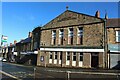
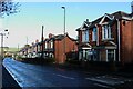
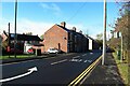
Photos of DH9 8BL


Area Information
DH9 8BL is a small residential cluster in England, home to 1279 residents. Its compact size fosters a close-knit community, with homes predominantly in private ownership. The area’s demographic profile suggests a mature population, with a median age of 47 and most residents aged 30–64. Daily life here is shaped by proximity to essential services, including retail outlets like Iceland Stanley and Aldi Front, and rail links to Chester and nearby stations. The presence of Tanfield School, a primary and academy school with a good Ofsted rating, underscores the area’s appeal to families. While the postcode covers a limited geographical footprint, its strategic connectivity to rail networks and nearby amenities ensures residents have access to broader opportunities. The low crime risk and absence of environmental constraints such as protected woodlands or flood-prone areas contribute to a stable, safe living environment. For those seeking a quiet, family-friendly neighbourhood with practical infrastructure, DH9 8BL offers a blend of residential comfort and functional accessibility.
- Area Type
- Postcode
- Area Size
- Not available
- Population
- 1279
- Population Density
- Not available
The property market in DH9 8BL is characterised by a strong emphasis on owner-occupied homes, with 68% of properties privately owned. This suggests a stable, long-term resident base rather than a transient rental market. The accommodation type is predominantly houses, which are typically associated with family living and may appeal to those seeking space and privacy. The small size of the area means the housing stock is limited, potentially leading to competition among buyers. For those considering the market, the focus on owner-occupation indicates lower turnover and a potential for long-term investment. However, the lack of flats or other property types may limit options for first-time buyers or those requiring different living arrangements. Proximity to rail links and schools could enhance the area’s desirability, though the compact nature of DH9 8BL means buyers must consider nearby surroundings for additional choices.
House Prices in DH9 8BL
No properties found in this postcode.
Energy Efficiency in DH9 8BL
Daily life in DH9 8BL is enriched by nearby amenities that cater to practical needs and leisure. Retail options include Iceland Stanley, Heron Stanley, and Aldi Front, providing access to groceries and everyday essentials within walking distance. These stores support a convenient shopping experience, reducing the need for long journeys. Rail connections to Bullion Lane, Station Road, and Chester offer easy access to broader networks, facilitating travel for work, shopping, or socialising. While the area lacks large parks or leisure facilities, the rail links and retail hubs contribute to a functional lifestyle. The compact nature of the postcode means residents must venture slightly beyond DH9 8BL for more extensive recreational options, but the immediate vicinity offers sufficient convenience for daily living. The blend of retail and transport infrastructure ensures a balanced approach to both practicality and connectivity.
Amenities
Schools
Residents of DH9 8BL have access to Tanfield School, a primary institution specialising in science and engineering, and Tanfield School, an academy with a good Ofsted rating. The presence of two schools under the same name suggests a phased educational structure, likely catering to different age groups. The primary school provides early education, while the academy offers secondary or specialist instruction, ensuring continuity for families. The good Ofsted rating for the academy indicates a reliable standard of teaching and facilities. For parents, this combination offers a seamless transition from primary to secondary education within the area. However, the limited number of schools means families may need to consider broader options beyond DH9 8BL for alternative educational paths. The proximity of these institutions to residential properties underscores the area’s suitability for families prioritising accessible schooling.
| Rank | School | Type | Entry gender | Ages |
|---|
Explore more schools in this area
Go to Schools tabDemographics
The community in DH9 8BL is predominantly composed of adults aged 30–64, with a median age of 47. Home ownership is high, at 68%, reflecting a stable residential base. The area is largely occupied by houses, with no significant presence of flats or other accommodation types. The predominant ethnic group is White, aligning with broader regional trends. The absence of specific deprivation data means the area’s socioeconomic profile is not detailed, but the high home ownership rate suggests a relatively secure financial position for residents. The age range indicates a mix of established households and those in their prime working years, potentially influencing local amenities and services. With no mention of diversity beyond the predominant group, the community’s cultural composition remains largely homogenous. The low median age also implies a population less reliant on elderly care services, which may affect local infrastructure priorities.
Household Size
Accommodation Type
Tenure
Ethnic Group
Religion
Household Composition
Age
Household Deprivation
NS-SEC
Explore more demographic insights in this area
Go to Demographics tabPlanning
Planning Constraints
- Flood RiskPremium
- Ramsar Wetland SitesPremium
- Area of Outstanding Natural BeautyPremium
- Protected Nature ReservePremium
- Protected WoodlandPremium