Area Overview for DH1 2YS
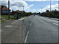
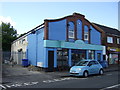
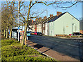
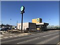
Photos of DH1 2YS


Area Information
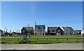
Living in DH1 2YS offers a quiet, residential experience in a small cluster of homes serving a population of 1,346. The area is characterised by its compact size and proximity to local amenities, making it practical for daily life. With a median age of 47, the community is predominantly composed of adults aged 30–64, suggesting a stable, established population. The area’s housing stock is largely made up of houses, reflecting a traditional, family-oriented environment. Nearby, retail outlets like Aldi Belmont and Tesco Durham provide convenience, while rail connections to Durham Railway Station and Bullion Lane, Chester offer access to regional transport networks. The presence of multiple primary schools, including Durham Gilesgate Primary School with a good Ofsted rating, highlights the area’s appeal to families. While the broadband quality is excellent, the high crime risk score demands attention, balancing the area’s practicality with a need for vigilance. DH1 2YS is a compact, functional postcode where proximity to essentials and a settled community shape daily life.
- Area Type
- Postcode
- Area Size
- Not available
- Population
- 1346
- Population Density
- Not available
The property market in DH1 2YS is defined by its 50% home ownership rate, with houses forming the predominant accommodation type. This indicates a market skewed towards owner-occupied properties rather than rentals, though the relatively low population and small area suggest limited housing stock. The focus on houses implies a preference for family homes, which may appeal to buyers seeking space and privacy. However, the compact nature of the postcode means the immediate surroundings are crucial for additional options. For buyers, this means competition could be fierce for available properties, and proximity to amenities like schools and transport is a key factor. The lack of flats or apartments suggests a more traditional housing landscape, which may align with those prioritising larger living spaces over urban convenience.
House Prices in DH1 2YS
No properties found in this postcode.
Energy Efficiency in DH1 2YS
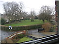
Daily life in DH1 2YS is shaped by its proximity to essential amenities. Retail options include Aldi Belmont, Iceland Dragonville, and Tesco Durham, providing grocery and household needs within walking or short driving distance. The rail network, with stations like Durham Railway Station, connects residents to nearby towns and cities, facilitating commuting or weekend trips. While the area lacks large leisure facilities, the presence of multiple primary schools suggests a community focus on education and family life. The small scale of the postcode means social interactions are likely to be local, fostering a tight-knit environment. For those prioritising convenience, the mix of retail and transport options ensures a practical, self-contained lifestyle, though larger recreational opportunities may require travel beyond the immediate area.
Amenities
Schools
Residents of DH1 2YS have access to several primary schools, including Durham Gilesgate Primary School, which holds a good Ofsted rating, and St Hild’s College Church of England Aided Primary School, Durham, listed twice in the data. Other options include Gilesgate Infant School and Gilesgate Junior School. The concentration of primary schools indicates a strong local educational infrastructure, catering to families with young children. The presence of multiple schools, including those with positive ratings, suggests a choice of educational environments, though the repetition of St Hild’s College may reflect data duplication. For parents, the availability of several primary schools within the area reduces the need for long commutes, supporting a family-friendly lifestyle. The mix of school types also allows for different pedagogical approaches, from state-funded to church-aided institutions.
| Rank | School | Type | Entry gender | Ages |
|---|
Explore more schools in this area
Go to Schools tabDemographics
DH1 2YS has a median age of 47, with the majority of residents falling within the 30–64 age range. This suggests a mature, stable population, likely with long-term ties to the area. Home ownership stands at 50%, indicating a mix of owner-occupied and rental properties, though the accommodation type is primarily houses rather than flats or apartments. The predominant ethnic group is White, reflecting the broader demographic trends in the region. While specific data on deprivation is not provided, the age profile and housing composition imply a community focused on family living and long-term residency. The absence of significant diversity data means the area’s social fabric is largely defined by its core demographic. For those considering relocation, the age group and housing type suggest a neighbourhood prioritising stability over transient lifestyles.
Household Size
Accommodation Type
Tenure
Ethnic Group
Religion
Household Composition
Age
Household Deprivation
NS-SEC
Explore more demographic insights in this area
Go to Demographics tabPlanning
Planning Constraints
- Flood RiskPremium
- Ramsar Wetland SitesPremium
- Area of Outstanding Natural BeautyPremium
- Protected Nature ReservePremium
- Protected WoodlandPremium