Area Overview for Cramlington
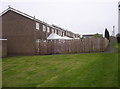
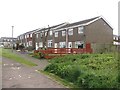
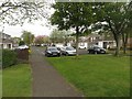
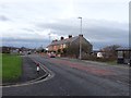
Photos of Cramlington


Area Information
Cramlington is a small, built-up area in England covering 9.0 km², home to 1,357 residents. With a population density of 151 people per square kilometre, it is a low-density community, offering a quiet, uncluttered lifestyle. The area’s demographic profile is distinct, with a median age of 70, suggesting a predominantly older population. This character is reflected in the local amenities and services, which cater to a mature demographic. Cramlington is well-served by primary schools, including Eastlea Primary School and Beaconhill Community Primary School, both rated ‘good’ by Ofsted. The town is also near Cramlington Railway Station, providing rail links to nearby areas. Retail options include Iceland, Asda, and M&S, ensuring daily essentials are within reach. Proximity to Newcastle Airport adds to its connectivity. For those seeking a peaceful, low-crime environment with practical amenities, Cramlington offers a straightforward, no-frills living experience.
- Area Type
- Built Up Area 250
- Area Size
- 9.0 km²
- Population
- 1357
- Population Density
- 151 people/km²
Residents of Cramlington have access to a range of amenities within practical reach, including retail outlets such as Iceland, Asda, and M&S, which cater to daily shopping needs. The area’s railway stations provide links to nearby towns and cities, while proximity to metro areas like Northumberland Park and Shiremoor adds to its connectivity. For leisure, the nearby Northumberland Park offers green space for walking or recreation. The presence of multiple primary schools and a low population density suggests a community-oriented lifestyle, with a focus on practicality over urban amenities. While the data does not mention dining or entertainment options, the retail and transport infrastructure indicate a functional, self-sufficient environment. The area’s amenities are sufficient for everyday needs but may not cater to those seeking a more vibrant, diverse lifestyle.
Amenities
Schools
Cramlington has five primary schools within practical reach, including Eastlea Primary School, Beaconhill Community Primary School, and Cramlington Shanklea Primary School, all of which hold ‘good’ Ofsted ratings. Other schools, such as Cramlington Cragside Church of England Controlled First School, are also available but lack explicit Ofsted ratings in the data. The presence of multiple primary schools ensures families have options, though the absence of secondary schools nearby may require residents to commute. The ‘good’ ratings at several schools suggest a generally high standard of education, which is a positive for families prioritising quality schooling. However, the data does not indicate the availability of secondary education or further education facilities, which could be a consideration for those with older children. Overall, the school mix supports a practical, family-friendly environment.
| Rank | School | Type | Entry gender | Ages |
|---|
Explore more schools in this area
Go to Schools tabDemographics
Cramlington’s population of 1,357 is relatively small, with a median age of 70, indicating a community skewed towards older adults. This age profile suggests a settled population, with fewer young families or students. Home ownership is high, at 70%, reflecting a stable housing market where most residents live in properties they own. The accommodation types and household composition are not specified, but the overall data implies a mix of family and single-occupancy homes. The area’s population density of 151 people per km² is low, contributing to a spacious, less congested environment. While specific data on ethnic diversity or religious composition is not provided, the demographics align with a traditional, older community. The low population density and high home ownership suggest a lifestyle prioritising privacy and stability over urban vibrancy.
Household Size
Accommodation Type
Tenure
Ethnic Group
Religion
Household Composition
Age
Household Deprivation
NS-SEC
Explore more demographic insights in this area
Go to Demographics tabPlanning
Planning Constraints
- Crime RiskPremium