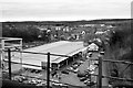
Area Overview for Chester-le-Street
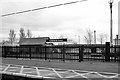
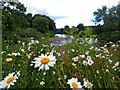
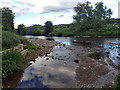
Photos of Chester-le-Street
Area Information
Chester-le-Street is a built-up area situated in County Durham, covering a total size of 6.7 square kilometres. This compact footprint supports a permanent population of 3,227 people, resulting in a population density of 479 people per square kilometre. You will find this concentration typical of a residential town where daily needs are within easy reach. The area functions as a established community hub rather than a sprawling suburb, with residents benefitting from a manageable scale throughout their day. Your morning or evening walks will traverse neighbourhoods where the population density creates a sense of local familiarity without the congestion of larger city centres. Living in Chester-le-Street means engaging with a defined space where the built environment accommodates its current inhabitants. The total population figure suggests a stable community structure where local services cater to specific demographic needs. You do not face the anonymity often associated with massive urban sprawls here. Instead, the area offers a concentrated living experience where neighbours interact regularly. The built-up nature means infrastructure is designed for efficient use of the limited land area. Your commute patterns may reflect this tight-knit layout, with destinations often located in close proximity to your street. The area size dictates that travel times between home and local hubs remain short for most residents. For those considering purchasing homes in this district, the physical characteristics of Chester-le-Street offer practical advantages. The defined boundaries create a clear sense of place that can be attractive to families seeking stability. You know exactly where the area begins and ends, which simplifies navigation and local planning. The population density indicates a thriving residential sector where demand for property remains consistent. Your experience of living here will be shaped by this specific mix of space and occupancy rates. The area maintains its identity as a cohesive town rather than becoming diluted by expansion.
- Area Type
- Built Up Area 250
- Area Size
- 6.7 km²
- Population
- 3227
- Population Density
- 479 people/km²
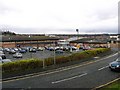
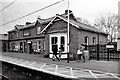
Your daily routine in Chester-le-Street benefits from a cluster of retail and rail amenities located within practical reach. Tesco Chester, Morrisons Waldridge Chester-le, and Iceland Chester-Le form the core of the local retail offering. These three major supermarkets ensure all your grocery and household needs remain easily accessible on a regular basis. Having multiple large stores nearby means you can choose between different shopping experiences or split your weekly shop across venues. Transportation links are equally convenient for residents without a private vehicle. Four railway stations – Station Road, Chester, Bullion Lane, and others – provide rail access from Chester-le-Street. These stations offer connections to wider regional networks, enabling you to travel to Newcastle, Durham, or beyond with ease. Additionally, South Hylton Metro station provides light rail connectivity, further expanding your travel options. This combination of rail and metro access integrates Chester-le-Street well into the broader transport network of County Durham. The mix of supermarkets and rail stations means you can manage home and life efficiently in one location. The presence of so many transport linkages within the area reduces the necessity for long daily commutes. Whether you are heading into the city or travelling home from work, Chester-le-Street places you near key gateways. The specified amenities – Tesco, Morrisons, Iceland, and the four rail stations – provide the backbone for a convenient, independent lifestyle.
Amenities
Schools
Families considering living in Chester-le-Street have access to a range of educational institutions within the immediate vicinity. Red Rose Primary School operates in the area with a Ofsted rating of good, offering a solid educational environment close to the neighbourhood. Cestria Primary School also serves the local community as a primary institution, maintaining a good Ofsted rating that signals quality teaching standards. These two schools represent the most highly rated options listed for residents in Chester-le-Street. South Pelaw Infant School, Newker Infant School, and Clarence Nursery School round out the local education provision. South Pelaw Infant School and Newker Infant School both function as primary entry points, though their specific Ofsted ratings are not listed in current records. Clarence Nursery School provides pre-primary education, catering to the youngest children in the community. This mix of nurseries and primary schools means that parents with young children can find support for early years learning without needing to travel far beyond the local boundaries. The presence of multiple primary and nursery schools suggests the region can accommodate families with children of different ages. You will find a concentration of educational facilities designed for the younger demographic, which contrasts with the older average age of the wider population. This discrepancy between school supply and resident age may indicate that families reside in the area while children temporarily attend these nearby institutions before moving on elsewhere, or that the schools serve a broader catchment area. Regardless, the schools listed – Red Rose, Cestria, South Pelaw, Newker, and Clarence – form the core network supporting local youth education.
| Rank | School | Type | Entry gender | Ages |
|---|
Explore more schools in this area
Go to Schools tabDemographics
The community structure in Chester-le-Street reflects a mature demographic profile with significant implications for your daily life. The median age stands at 70 years, indicating a population heavily skewed towards older adults compared to national averages. This age distribution shapes the character of Chester-le-Street as a retirement-focused neighbourhood where many residents have long-term ties to the local area. Housing stock and local amenities often cater to the specific needs of this older demographic, influencing everything from home design to available services. Home ownership represents a major feature of the local landscape, with 69% of residents owning their properties outright or with a mortgage. This high ownership rate suggests stability within the community and reduces the volatility often seen in areas dominated by rentals. You will encounter many long-term homeowners who have invested in their neighbourhoods over decades. This ownership culture fosters a sense of commitment among residents. The households in Chester-le-Street are characterised by this strong property connection, which often correlates with lower mobility rates. Accommodation types across Chester-le-Street align with the high ownership percentage, meaning single-family homes and flats suitable for older adults dominate the market. The area does not function as a primary commuter zone for young professionals or students, given the age profile. Diversity metrics in Chester-le-Street follow typical patterns for the region, with the predominant ethnic group reflecting the broader North East context. Religious affiliations generally mirror regional trends, though specific denominations are not detailed in available records. The overall demographic picture presents a quiet, settled environment where the older majority defines the community rhythm.
Household Size
Accommodation Type
Tenure
Ethnic Group
Religion
Household Composition
Age
Household Deprivation
NS-SEC
Explore more demographic insights in this area
Go to Demographics tabPlanning
Planning Constraints
- Crime RiskPremium