Area Overview for Bridges Ward
Photos of Bridges Ward


Area Information
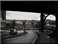
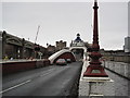
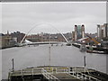
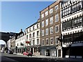
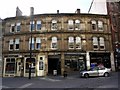
Bridges Ward sits at the heart of Newcastle upon Tyne, covering a compact district of 3.2 km² straddling the River Tyne. This electoral ward is defined by its location around the historic bridges that link the city to Gateshead. The Swing Bridge, completed in 1876, remains a prominent architectural feature within the area, allowing vessels to pass between the two banks. It is part of the wider collection of seven bridges that offer iconic views across the water. Life here centres on the central Newcastle transport network, with Newcastle Central station positioned nearby to provide rapid rail links to London and the rest of the country. You find yourself living in a location where major infrastructure meets historical significance. The ward encompasses areas directly under or adjacent to these crossings, creating a neighbourhood bounded by the water and these vital transport arteries. While the area is small, its position makes it integral to the city's connectivity. Residents enjoy proximity to key landmarks and the flow of pedestrian and vehicular traffic that defines the daily rhythm of this central locale. The landscape is characterised by the riverfront and the structures that bridge the gap between the historic city centre and the growing urban sprawl of Gateshead.
- Area Type
- District Borough Unitary Ward
- Area Size
- 3.2 km²
- Population
- Not available
- Population Density
- Not available
Demographics
The community within Bridges Ward has a distinctly mature character, with a median age of 70 years. This indicates that the population skews heavily towards older residents who may have moved to the area for retirement or proximity to healthcare and leisure facilities suitable for later life. You should be aware that the total population data aggregates these age groups, highlighting the prominence of the over-70 demographic compared to working-age cohorts. Home ownership stands at 35 per cent, which suggests a significant portion of the ward operates as a rental market rather than a privately owned territory. This statistic is unusual for an area with such high median age, as one might expect higher ownership rates among retirees. The household composition, accommodation types, predominantly ethnic group, and religious affiliations are recorded as total aggregates in the available census information, meaning specific breakdowns for these categories are not detailed in the current dataset. For those considering homes in Bridges Ward, the rental sector will likely be your primary market, alongside a mix of owner-occupied properties catering to the older demographic.
Household Size
Accommodation Type
Tenure
Ethnic Group
Religion
Household Composition
Age
Household Deprivation
NS-SEC
Explore more demographic insights in this area
Go to Demographics tabPlanning
Planning Constraints
- Flood RiskPremium
- Ramsar Wetland SitesPremium
- Area of Outstanding Natural BeautyPremium
- Protected Nature ReservePremium
- Protected WoodlandPremium
- Crime RiskPremium