Area Overview for Alnmouth
Photos of Alnmouth


Area Information
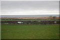
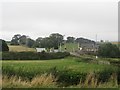
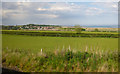
Alnmouth is a small coastal village and civil parish situated in Northumberland, North East England. It occupies an area of 5.4 km² at the mouth of the River Aln where it meets the North Sea. The location is approximately 4 miles east-south-east of Alnwick and 29 miles north of Newcastle upon Tyne. This distinctive setting places residents near the Northumberland Coast Area of Outstanding Natural Beauty. Historical evidence suggests settlement dates back to the 8th or 9th century, with an Anglo-Saxon cross located on Church Hill. A former port used for fishing and trade, the village silted up around 200 years ago. The arrival of the railway in the 1840s later transformed the location into a coastal resort. Today, the area features pastel-coloured houses overlooking the estuary alongside tranquil sandy beaches and saltmarsh. The population stands at 445 according to the 2011 Census, with figures showing 444 in 2021. Living in Alnmouth offers a peaceful seaside atmosphere valued by birdwatchers and those seeking relaxation. You will find well-conserved architecture and a quiet environment that defines daily life here.
- Area Type
- Parish
- Area Size
- 5.4 km²
- Population
- Not available
- Population Density
- Not available
Demographics
The community profile of Alnmouth reflects a mature population structure. The median age for residents is 70 years old. This high average indicates that the village primarily serves older people rather than young families or professionals. The data does not specify the exact breakdown of the most common age range beyond stating the total age category. Home ownership is a defining feature of the locality, with 66 percent of households owning their properties. This high rate suggests long-term settlement and stability within the community. Detailed statistics on household composition and the predominant ethnic group are not listed in the current records. Similarly, specific data regarding religious affiliations among residents is not available in the provided information. The lack of data on specific household types prevents a full analysis of family structures. However, the high home ownership percentage strongly implies that many residents have lived in their homes for extended periods. When assessing quality of life, the low crime risk offers a strong point of reassurance for potential buyers. The demographic profile confirms that Alnmouth is a retirement-focused destination rather than a hub for young workers or transient populations.
Household Size
Accommodation Type
Tenure
Ethnic Group
Religion
Household Composition
Age
Household Deprivation
NS-SEC
Explore more demographic insights in this area
Go to Demographics tabPlanning
Planning Constraints
- Flood RiskPremium
- Ramsar Wetland SitesPremium
- Area of Outstanding Natural BeautyPremium
- Protected Nature ReservePremium
- Protected WoodlandPremium
- Crime RiskPremium