Area Overview for Walbrook Ward
Photos of Walbrook Ward


Area Information
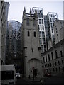
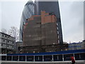
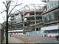
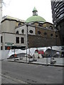
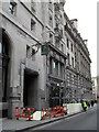
Walbrook Ward is a compact district within the City of London, covering an area of just 7.5 hectares. This ward sits at the heart of the financial district, stretching along main streets from Cannon Street towards the Mansion House. You will find yourself walking among significant historical landmarks, including the Bank of England and St Stephen Walbrook. The name derives from the Walbrook, a river that once flowed through the centre before reaching the Thames. While the modern architecture reflects its construction after the Great Fire of 1666, the street layout dates back to 886 when King Alfred re-established the city. Living in Walbrook Ward places you in a zone of immense civic importance, where the former stocks market once traded fish and flesh. The Grocers' Company maintained standards for spice purity here in the 14th century. Archaeological findings near Old Jewry reveal a medieval mikveh, highlighting long-standing Jewish settlement. Although the area is small, it carries centuries of commercial weight. Your daily walks will take you past the site of the Mansion House and the historic London Stone. This ward houses no Ramsar wetland sites or areas of outstanding natural beauty, focusing instead on dense urban development. Living here connects you directly to London's financial governance and civic history.
- Area Type
- District Borough Unitary Ward
- Area Size
- 7.5 hectares
- Population
- Not available
- Population Density
- Not available
Demographics
The demographic profile of Walbrook Ward is distinct due to its status as a central business district. The median age for residents is 70 years, indicating a population skewed heavily towards the elderly. This age profile suggests the area attracts retired professionals rather than young families. Home ownership stands at exactly 25%, meaning three-quarters of residents rent their accommodation. Consequently, the community feels transient compared to suburban London wards. The ward encompasses a total count of household compositions and accommodation types, though specific breakdowns by family size or single-person households are not detailed in available records. As an area with a median age of 70, daily life likely centres around quiet evenings and established routines. You might expect fewer children playing in the streets, reflecting the high average age. The low home ownership rate implies that tenancy is the norm, which often leads to higherturnover neighbourhoods. Diversity data regarding predominant ethnic groups and religious affiliations are recorded only as total figures, lacking further specificity. This lack of granular demographic data means you cannot fully assess the cultural mix without external research. For those seeking a stable community with deep local roots, the statistics present a challenge. However, for someone preferring a professional, low-density environment, the demographic make-up aligns with a retirement or executive living arrangement. You should consider whether a renter-heavy area with an old population suits your lifestyle expectations.
Household Size
Accommodation Type
Tenure
Ethnic Group
Religion
Household Composition
Age
Household Deprivation
NS-SEC
Explore more demographic insights in this area
Go to Demographics tabPlanning
Planning Constraints
- Flood RiskPremium
- Ramsar Wetland SitesPremium
- Area of Outstanding Natural BeautyPremium
- Protected Nature ReservePremium
- Protected WoodlandPremium