Area Overview for W6 8JS
Photos of W6 8JS

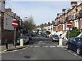
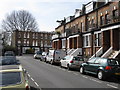
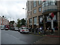

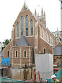


100 photos from this area
Area Information
Key information about the W6 8JS including its size, population, and administrative classification.
- Area Type
- Postcode
- Area Size
- 7425 m²
- Population
- 1389
- Population Density
- 9673 people/km²
House Prices in W6 8JS
60
Properties
£911,033
Average Sold Price
£103,500
Lowest Price
£1,415,000
Highest Price
Showing 60 properties
| Address | Type | Beds | Baths | Last Sale Price | Last Sale Date | |
|---|---|---|---|---|---|---|
| 81 Beryl Road, London, W6 8JS | Terraced | 4 | 2 | £1,295,000 | Dec 2024 | |
| 45 Beryl Road, London, W6 8JS | Terraced | 4 | 2 | £1,210,000 | Dec 2024 | |
| 21 Beryl Road, London, W6 8JS | Terraced | 3 | 2 | £1,075,000 | Jul 2024 | |
| 27 Beryl Road, London, W6 8JS | Terraced | 4 | 2 | £1,070,000 | Jul 2023 | |
| 51 Beryl Road, London, W6 8JS | Terraced | 4 | 2 | £1,270,000 | Apr 2023 | |
| 7 Beryl Road, London, W6 8JS | Terraced | 4 | 3 | £1,415,000 | Oct 2022 | |
| 61 Beryl Road, London, W6 8JS | house | - | - | £1,125,000 | Jan 2021 | |
| 13 Beryl Road, London, W6 8JS | Terraced | 3 | 1 | £955,250 | Sep 2020 | |
| 75 Beryl Road, London, W6 8JS | house | 3 | 1 | £925,000 | Sep 2019 | |
| 49 Beryl Road, London, W6 8JS | house | 5 | 3 | £1,145,000 | Jun 2018 |
Page 1 of 6
Energy Efficiency in W6 8JS
Amenities
Schools
| Rank | School | Type | Entry gender | Ages |
|---|
Explore more schools in this area
Go to Schools tabDemographics
Household Size
Family (3-5 people)
most common
Accommodation Type
Flats
most common
Tenure
46
majority
Ethnic Group
White
most common
Religion
N/A
most common
Household Composition
N/A
most common
Age
47
median
Adults (30-64 years)
most common
Household Deprivation
N/A
with no deprivation
NS-SEC
55
in Lower managerial occupations
Explore more demographic insights in this area
Go to Demographics tabPlanning
Planning Constraints
- Flood RiskPremium
- Ramsar Wetland SitesPremium
- Area of Outstanding Natural BeautyPremium
- Protected Nature ReservePremium
- Protected WoodlandPremium