Area Overview for SW12 8TY
Photos of SW12 8TY

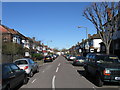
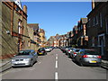
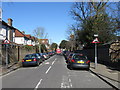
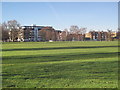
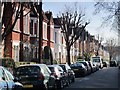

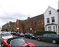
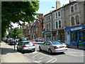
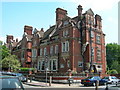
100 photos from this area
Area Information
Key information about the SW12 8TY including its size, population, and administrative classification.
- Area Type
- Postcode
- Area Size
- 1.6 hectares
- Population
- 1657
- Population Density
- 8064 people/km²
House Prices in SW12 8TY
55
Properties
£2,390,444
Average Sold Price
£300,000
Lowest Price
£5,850,000
Highest Price
Showing 55 properties
| Address | Type | Beds | Baths | Last Sale Price | Last Sale Date | |
|---|---|---|---|---|---|---|
| 89 Thurleigh Road, London, SW12 8TY | Detached | 7 | 4 | £5,850,000 | May 2025 | |
| 105 Thurleigh Road, London, SW12 8TY | Semi-detached | 4 | 2 | £2,110,000 | Sep 2023 | |
| 111 Thurleigh Road, London, SW12 8TY | Semi-detached | 3 | 1 | £1,680,000 | Nov 2022 | |
| 115 Thurleigh Road, London, SW12 8TY | Detached | - | - | £1,440,000 | Sep 2022 | |
| 113 Thurleigh Road, London, SW12 8TY | house | - | - | £1,820,000 | Nov 2020 | |
| 123 Thurleigh Road, London, SW12 8TY | house | - | - | £4,817,500 | Aug 2017 | |
| 85 Thurleigh Road, London, SW12 8TY | Terraced | 7 | 3 | £4,400,000 | Apr 2014 | |
| The Coach House, 79 Thurleigh Road, London, SW12 8TY | Semi-detached | 4 | 1 | £4,100,000 | Jul 2013 | |
| 89A Thurleigh Road, London, SW12 8TY | house | - | - | £3,250,000 | May 2010 | |
| 81 Thurleigh Road, London, SW12 8TY | Semi-detached | - | - | £1,850,000 | Feb 2006 |
Page 1 of 6
Energy Efficiency in SW12 8TY
Amenities
Schools
| Rank | School | Type | Entry gender | Ages |
|---|
Explore more schools in this area
Go to Schools tabDemographics
Household Size
Family (3-5 people)
most common
Accommodation Type
Houses
most common
Tenure
72
majority
Ethnic Group
White
most common
Religion
N/A
most common
Household Composition
N/A
most common
Age
47
median
Adults (30-64 years)
most common
Household Deprivation
N/A
with no deprivation
NS-SEC
67
in Lower managerial occupations
Explore more demographic insights in this area
Go to Demographics tabPlanning
Planning Constraints
- Flood RiskPremium
- Ramsar Wetland SitesPremium
- Area of Outstanding Natural BeautyPremium
- Protected Nature ReservePremium
- Protected WoodlandPremium