Area Overview for Sutton (Sutton)
Photos of Sutton (Sutton)


Area Information
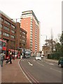
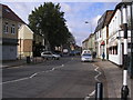
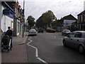
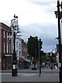
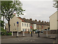
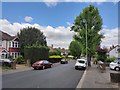
Living in Sutton offers a distinct blend of suburban tranquility and convenient access to central London. This local authority district serves as the London Borough of Sutton, situated approximately 14 miles south of Charing Cross. The area covers 36.3 km² and houses a population of 133,828 residents. Historically an ancient parish in Surrey, Sutton evolved from a rural setting into a prominent commuter town following 19th-century rail and road developments. You will find the community centred around coordinates that define its geography within Greater London. The transition from its past as a rural parish to its current status reflects over a century of planned growth. Residents enjoy proximity to the historic London to Brighton turnpike route established in 1755. Today, the town combines historical significance with modern infrastructure. Sutton remains a key location for those seeking a balance between established character and urban convenience. The area's layout supports a variety of lifestyle needs, from family living to commuter convenience. You can access services that mirror those found in larger metropolitan centres while retaining a defined townscape. The location continues to attract interest from homebuyers who value its specific place in south London.
- Area Type
- District/Borough
- Area Size
- 36.3 km²
- Population
- 133828
- Population Density
- 3686 people/km²
Demographics
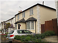
The community in Sutton is defined by a mature population and a culture of home ownership. The median age for residents is 70, indicating a very senior demographic across the borough. Household composition and accommodation type data suggest that the area caters primarily to established residents rather than young families or students. Sixty-seven per cent of households are owner-occupiers, reflecting a stable, long-term resident base. This high rate of ownership contrasts sharply with faster-growing rental hotspots elsewhere in London. The population density reaches 3,686 people per square kilometre, creating a relatively compact living environment for the borough's size. You will likely encounter a neighbourhood where neighbours know each other and residents plan for retirement or later-life living more than child-rearing. The demographic profile supports services targeted at older adults rather than the typical young professional clusters found in central London. Understanding this age distribution helps you anticipate the local pace of life and the types of amenities nearby. The area does not show signs of rapid demographic turnover or transient living arrangements. Instead, it stands as a settled district with clear social structures. The property market in Sutton reflects a settled community where ownership is the norm. Sixty-seven per cent of homes are in private ownership, meaning the vast majority of the housing stock is occupied by the owners. This high proportion of owner-occupiers indicates that Sutton is primarily an established residential area rather than a high-flyer rental market. You are competing with people who intend to stay for decades, which often stabilises house prices and reduces turnover. The borough encompasses 36.3 km² of territory, providing a reasonable volume of housing options within a manageable geographic footprint. The predominance of home ownership suggests that the accommodation types prevalent here cater to families, retirees, and downsizers who value stability. There are few evidence-based indicators of speculative short-term letting in the available data. If you are looking at Sutton, you are entering a market where residents treat their homes as long-term assets. This reality creates a different dynamic than areas dominated by leaseholders or renters. The housing environment supports those who wish to build equity and settle permanently. Buyers should expect a market driven by local families and retirees rather than transient workers.
Household Size
Accommodation Type
Tenure
Ethnic Group
Religion
Household Composition
Age
Household Deprivation
NS-SEC
Explore more demographic insights in this area
Go to Demographics tabPlanning
Planning Constraints
- Crime RiskPremium