Area Overview for SE9 5LD
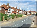
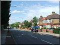
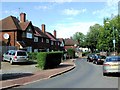
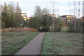
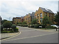
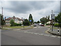
Photos of SE9 5LD


Area Information
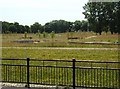
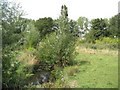
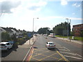
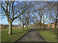
Living in SE9 5LD means residing in a specific postcode cluster within the broader London property market. This small residential area forms a tight-knit part of the surrounding neighbourhoods. The core population stands at 1,618 people, creating a relatively quiet domestic environment compared to the wider capital. You will find yourself moving through streets defined by established character rather than rapid urban expansion. The area sits comfortably near significant transport hubs, including access to rail stations like Kidbrooke, Eltham, and Lee within practical reach. You also benefit from proximity to major crossing points such as Cutty Sark DLR Station and Greenwich Pier, offering diverse routes for commuting or leisure trips. London City Airport remains a key feature for residents requiring frequent business flights. Daily life here balances suburban tranquility with convenient access to wider London infrastructure. The density is low enough to ensure privacy while maintaining connectivity to essential services. Whether you prefer walking to a local shop or taking a train to central London, the layout supports both active and drawn-out modes of travel. This postcode represents a stable slice of London living where residents value their immediate surroundings without sacrificing transport links.
- Area Type
- Postcode
- Area Size
- Not available
- Population
- 1618
- Population Density
- 4286 people/km²
Homes in SE9 5LD are defined by a specific ownership structure that shapes the local property market. With a home ownership rate of 72%, this postcode operates significantly as an owner-occupied market rather than a rental-dominated zone. You will find mostly houses dominating the housing stock, which appeals to families seeking larger living spaces or garden access. The high proportion of owners indicates that many buyers have chosen this location for its stability and long-term value. For prospective purchasers, this means you are entering an environment where sellers are often keen to leave a lasting legacy rather than flipping assets quickly. The composition of the area as a residential cluster of houses suggests a focus on traditional living standards over high-density apartments. While specific price data is absent from the current information, the ownership statistics point towards a market where buyers commit to permanent tenure. This dynamic contrasts with areas where 80% or more of homes are privately rented. You will find a consistency in the types of properties available, largely avoiding the mixed-use intensity seen in central London. The market here rewards patience and due diligence, reflecting the established nature of the housing stock in this postcode sector.
House Prices in SE9 5LD
No properties found in this postcode.
Energy Efficiency in SE9 5LD
Life in SE9 5LD offers immediate access to a variety of essential amenities within practical reach. Retail options are well-catered for, with five notable outlets including Tesco Clifton, Co-op Westhorne, and Tesco Eltham. These supermarkets provide you with the ability to complete weekly grocery shopping without long travel times.Transport connectivity is woven into your daily routine with five rail stations nearby, including Kidbrooke, Eltham, and Lee. You can choose from five metro stations such as Elverson Road and Cutty Sark DLR Station for direct underground access. Water lovers have five ferry points available, including Greenwich Pier and Barrier Gardens Pier, making trips to the peninsula convenient. Additionally, London City Airport is situated just one away, ideal for business travel or occasional holiday flights. This density of services ensures you rarely feel isolated despite the small residential cluster. Whether you need to refuel your car, catch a train, or fund a day out by boat, these amenities are all strategically located near your postcode. The variety caters to both daily necessities and leisure pursuits, supporting a balanced lifestyle.
Amenities
Schools
Education opportunities near SE9 5LD are limited in number but distinct in character. The nearest independent school is Colfe's School, which stands as the primary educational option referenced for this location. As an independent institution, it offers an alternative pathway to the state education system. The presence of one named school suggests a dependent relationship with the wider catchment area for state provision, although specific Dame, infant, or secondary schools are not listed in the current data. Families considering this postcode must look beyond the immediate boundaries for comprehensive state education, relying on the single independent option prominently associated with the wider neighbourhood. The availability of a private school aligns with the area's demographic profile of higher home ownership and older households, who often seek specific educational environments for their children. The lack of listed community schools means parents may need to commute further for state-maintained options. This educational landscape adds a layer of selectivity to the area, attracting parents who value independent education or possess the resources to navigate the wider school catchment area for state schools.
| Rank | School | Type | Entry gender | Ages |
|---|
Explore more schools in this area
Go to Schools tabDemographics
The community in SE9 5LD is heavily skewed towards established residents. Households here are predominantly occupied by adults aged between 30 and 64 years. The median age for the population is 47, which paints a clear picture of a neighbourhood favoured by families or those in their mid-career stages. You will encounter a high rate of home ownership, with 72% of properties held by their owners. This statistic confirms that the area is not driven by short-term rentals or transient populations. The typical accommodation type consists of houses, reinforcing the family-oriented nature of the location. The demographic profile is primarily White, reflecting a settled and traditional community structure. There is a notable absence of younger singles or students in the immediate vicinity, unlike areas with higher rental turnover. This demographic stability contributes to a consistent social fabric. Residents here tend to be invested in their long-term homes rather than viewing property as a temporary investment vehicle. The age profile suggests a mature community where neighbours likely know each other well. You can expect a quiet atmosphere where daily life revolves around the needs of working adults and families rather than nightlife or student gatherings.
Household Size
Accommodation Type
Tenure
Ethnic Group
Religion
Household Composition
Age
Household Deprivation
NS-SEC
Explore more demographic insights in this area
Go to Demographics tabPlanning
Planning Constraints
- Flood RiskPremium
- Ramsar Wetland SitesPremium
- Area of Outstanding Natural BeautyPremium
- Protected Nature ReservePremium
- Protected WoodlandPremium