Area Overview for SE9 2DP
Photos of SE9 2DP


Area Information
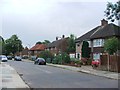
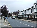
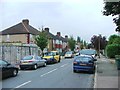
Living in SE9 2DP offers a quiet suburban experience within the Royal Borough of Greenwich. This specific postcode covers a small residential cluster with a population of exactly 1,964 people. The area sits between the town centre and the open green spaces of Avery Hill, creating a lifestyle that balances urban convenience with countryside tranquillity. You will find yourself in a residential setting where the pace is generally slower than in central London. The cluster forms part of the Eltham Town & Avery Hill ward, an area established in the 2022 elections that encompasses homes extending east towards Avery Hill. The history of this location is deep; human activity dates back to the Mesolithic period with flint found in Avery Hill Park. Land here was recorded in the Domesday Book as 'Eald Ham'. While the area now functions as a modern suburban pocket, it retains a connection to its past. The character is distinctly residential, focused on housing rather than commerce. Residents here enjoy proximity to significant local landmarks without the immediate noise of a high street. The postcode serves as a gateway to wider amenities, including Eltham Palace and Avery Hill Park, which feature a restored Tudor Conduit and Britain's largest Canary date palm. This mix of historic backdrop and modern residential life defines daily existence in this small but distinct community.
- Area Type
- Postcode
- Area Size
- Not available
- Population
- 1964
- Population Density
- 6092 people/km²
The property market in SE9 2DP is characterised by a strong presence of owner-occupiers. With 63% of homes owned, the area is not a primary hub for private landlords or short-term holiday lets. Instead, it functions as a traditional residential market where buyers seek permanent homes. The predominant accommodation type is houses, which means you will find terraced, semi-detached, and detached properties rather than high-rise flats. This profile suggests that the housing stock caters to families and retirees who value space and privacy. Properties here are likely to be suitable for long-term settlement. When you look at homes in SE9 2DP, you are looking at a sector where people have put down roots. The lower density of rental properties reduces competition for tenancies but also indicates a market driven by private sales. This stability often leads to predictable maintenance standards within the housing cluster. Buyers should expect a market that moves with the local economy rather than fluctuating wildly based on student demand or tourist trends. The focus on houses over apartments shapes the local real estate landscape distinctly.
House Prices in SE9 2DP
No properties found in this postcode.
Energy Efficiency in SE9 2DP
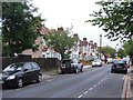
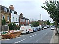
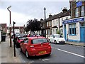
Daily life in SE9 2DP is enriched by a network of amenities within practical reach. For shopping needs, you have access to five retail locations, including Co-op New, Co-op University of, and Co-op Valliers. These convenient options handle most daily grocery and household requirements without needing a lengthy journey. Your leisure and travel options are equally diverse. Five notable rail and ferry connections sit nearby, including Woolwich Arsenal Pier, Woolwich Ferry North Pier, and Barrier Gardens Pier. These waterways provide alternative routes for commuting or leisure trips across the Thames. Local transport hubs like London City Airport sit just one mile away, making short business trips or holiday travel straightforward. The area is also defined by its green spaces. Avery Hill Park offers restored historic features like the Tudor Conduit and Henley's Field, a wild flower meadow. Eltham Palace stands as a key landmark for visitors and residents alike. This blend of practical retail, varied transport, and historic parkland creates a lifestyle that feels both functional and enjoyable.
Amenities
Schools
Families considering schools near SE9 2DP have access to Wyborne Primary School. This school holds an Ofsted rating of good, providing reassurance about educational quality for children in the area. You will also find Wyborne Infant School serving the younger age groups within the local catchment. These institutions are the main school-based amenities identified for this postcode. The presence of primary schools indicates that families with young children do reside in SE9 2DP. While secondary school options are not listed in the data, the existence of infants and primary schools confirms the presence of a local education route for early learning. For parents, this means children can access schooling without relying on distant catchment zones. The mix of infant and primary facilities allows for a continuous educational path within the immediate community. If you are looking for a school with a proven track record, Wyborne Primary School offers the specific rating data you would expect before committing to a move.
| Rank | School | Type | Entry gender | Ages |
|---|
Explore more schools in this area
Go to Schools tabDemographics
The community in SE9 2DP is defined by stability and maturity. Your neighbours are primarily adults between the ages of 30 and 64 years, reflecting a resident population with significant life experience. The median age of 47 years confirms that this is not an area dominated by students or very young families adjusting to life in London. Consequently, the atmosphere is calm and established. Home ownership stands at 63%, indicating that the majority of residents have purchased their homes rather than renting. This high level of ownership suggests people have chosen to settle in SE9 2DP long term. The predominant accommodation type is houses, which aligns with the preference of older demographics for single-family living over apartments. The social fabric is predominantly White, consistent with the older, established nature of the ward. Low levels of deprivation are implied by this stable age profile and high ownership rate. You are entering a neighbourhood where long-term residents have invested in their surroundings. The demographic data points to a community where children, if present, likely live with parents who have lived in the area for decades. This creates a predictable environment where the focus remains on established routines rather than rapid social change.
Household Size
Accommodation Type
Tenure
Ethnic Group
Religion
Household Composition
Age
Household Deprivation
NS-SEC
Explore more demographic insights in this area
Go to Demographics tabPlanning
Planning Constraints
- Flood RiskPremium
- Ramsar Wetland SitesPremium
- Area of Outstanding Natural BeautyPremium
- Protected Nature ReservePremium
- Protected WoodlandPremium