Area Overview for SE9 2BZ
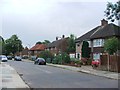
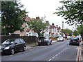
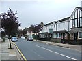
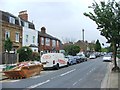
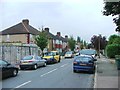
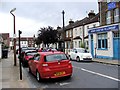
Photos of SE9 2BZ


Area Information
Living in SE9 2BZ offers a residential experience defined by a specific postcode cluster covering 7,083 square metres within the Royal Borough of Greenwich. This small, concentrated area forms part of the wider Eltham Town and Avery Hill electoral ward, situated approximately 8.7 miles east-southeast of Charing Cross. The immediate locality supports a population of 1,964 residents, creating a neighbourhood large enough for community interaction but small enough to retain a village-like character. You move through a setting that blends suburban living with access to significant green spaces, including Avery Hill Park and the nearby Eltham Palace landmark. The area retains a distinct identity as it sits between the urban development of Eltham and the countryside surrounding Avery Hill. Historical layers shape the current landscape, from the Mesolithic period evidenced by flint findings in the park to land recorded in the Domesday Book. You inhabit a zone where history, represented by the restored Winter Garden with its large Canary date palm, coexists with modern family life. This small cluster provides a stable environment where daily routines connect directly to the broader amenities of Eltham while remaining insulated by the boundaries of the specific postcode.
- Area Type
- Postcode
- Area Size
- 7083 m²
- Population
- 1964
- Population Density
- 6092 people/km²
The property market in SE9 2BZ is characterised by a predominantly owner-occupied stock, with 63% of residents holding their homes outright or with a mortgage. This statistic confirms that the area functions as a family home zone rather than a transient rental market. Houses form the core of the accommodation type inventory, distinguishing this postcode from urban districts dominated by flats or studio apartments. For homebuyers looking at this specific area, the prevalence of houses suggests larger living spaces and private gardens, key features for households seeking permanence. The high home ownership rate often correlates with slower price fluctuations and a community that values local stability. When viewing homes in SE9 2BZ, you are entering a market where sellers are often motivated by lifestyle needs rather than portfolio management. The accommodation type being almost entirely houses reinforces the suburban feel of Eltham Town and Avery Hill. You should expect a market where properties have been occupied by the same families for generations, leading to a stable, if occasionally slower, turnover rate compared to areas with higher student or rental demand.
House Prices in SE9 2BZ
Showing 22 properties
| Address | Type | Beds | Baths | Last Sale Price | Last Sale Date | |
|---|---|---|---|---|---|---|
| 8 Alverstone Gardens, New Eltham, SE9 2BZ | Terraced | 3 | 1 | £502,500 | Apr 2023 | |
| 5 Alverstone Gardens, New Eltham, SE9 2BZ | Terraced | 3 | 1 | £420,000 | Nov 2019 | |
| 3 Alverstone Gardens, New Eltham, SE9 2BZ | Terraced | 3 | 1 | £388,000 | Oct 2017 | |
| 4 Alverstone Gardens, New Eltham, SE9 2BZ | Terraced | 3 | 1 | £397,500 | Jun 2016 | |
| 9 Alverstone Gardens, New Eltham, SE9 2BZ | house | - | - | £385,000 | Oct 2015 | |
| 16 Alverstone Gardens, New Eltham, SE9 2BZ | house | - | - | £455,000 | Oct 2015 | |
| 22 Alverstone Gardens, New Eltham, SE9 2BZ | Terraced | 3 | 1 | £281,000 | Nov 2013 | |
| 14 Alverstone Gardens, New Eltham, SE9 2BZ | house | 3 | - | £205,000 | Aug 2011 | |
| 19 Alverstone Gardens, New Eltham, SE9 2BZ | house | 3 | - | £250,000 | Jul 2010 | |
| 1 Alverstone Gardens, New Eltham, SE9 2BZ | Semi-detached | 3 | - | £230,000 | Jun 2010 |
Energy Efficiency in SE9 2BZ
Your daily life in SE9 2BZ benefits from a wide array of amenities situated within a practical reach of the residence. Retail options include three notable Co-operatives located at Co-op New, Co-op University of, and Co-op Valliers, providing convenient access to groceries and daily essentials. Transport links are similarly diverse, with five local railway options including New Eltham, Mottingham, and Falconwood stations allowing easy commuting and access to the capital. You also have five nearby ferry locations at Woolwich Arsenal Pier, Woolwich Ferry North Pier, and Barrier Gardens Pier, offering unique river transport connections. For quick navigation across the borough, five nearby metro stops serve King George V, Elverson Road, and London City Airport. The presence of London City Airport only 1 mile away adds considerable value for business travellers or aircraft enthusiasts. Parks such as Avery Hill Park and the restored Winter Garden are key leisure features, offering green space just off the postcode. This blend of retail, rail, river transport, and open space creates a balanced lifestyle where you do not have to travel far for shops, schools, or recreation.
Amenities
Schools
Families considering homes in SE9 2BZ will find two primary education establishments nearby that cater to the needs of the local children. Wyborne Primary School holds a 'good' Ofsted rating, confirming a standard of quality recognised by the Department for Education. Wyborne Infant School serves as a feeding school, providing early years education before pupils transition to the junior section or other provisions. This mix means you have immediate access to state-funded primary education within a short catchment distance. The absence of secondary schools listed in the immediate vicinity suggests that older pupils likely travel to other schools in the Royal Borough of Greenwich or beyond. Localised education options remain strong for young children, supporting families who prioritise neighbourhood schooling. The presence of these specific institutions anchors the community for parents, ensuring that children growing up in the area have established educational pathways nearby. The 'good' rating at Wyborne Primary School provides a clear indicator of performance for prospective homebuyers evaluating the area for their children's future.
| Rank | School | Type | Entry gender | Ages |
|---|
Explore more schools in this area
Go to Schools tabDemographics
The community residing in SE9 2BZ reflects a settled demographic profile, with a median age of 47 years. Most commonly, the population consists of adults between the ages of 30 and 64, indicating a neighbourhood dominated by families and established professionals rather than young renters or the elderly. Approximately 63% of residents own their homes, pointing to a community with deep roots and long-term residency. This high level of home ownership stabilises the local character and suggests a wealthier demographic compared to average national figures. The predominant ethnic group in your immediate vicinity is White. Almost exclusively, the accommodation available in this specific cluster comprises houses, meaning you will not find high-rise flats or purpose-built tower blocks in this immediate location. The population density reaches an exceptionally high 277,301 people per square kilometre, which highlights the intense concentration of people within the very small 7,083 square metre address area. Despite this density on the map, the housing type remains traditional family homes. This demographic mix creates a quiet yet vibrant community where life is centred around the suburb rather than the city centre.
Household Size
Accommodation Type
Tenure
Ethnic Group
Religion
Household Composition
Age
Household Deprivation
NS-SEC
Explore more demographic insights in this area
Go to Demographics tabPlanning
Planning Constraints
- Flood RiskPremium
- Ramsar Wetland SitesPremium
- Area of Outstanding Natural BeautyPremium
- Protected Nature ReservePremium
- Protected WoodlandPremium