Area Overview for SE9 1UA
Photos of SE9 1UA

Area Information
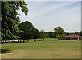
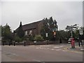
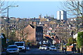
SE9 1UA represents a specific postcode area covering a small residential cluster within the Royal Borough of Greenwich. This location sits within the Eltham Town and Avery Hill ward, an area that blends suburban living with urban convenience. The cluster contains a population of 1,753 residents, creating a relatively intimate neighbourhood scale. Historically, the surrounding land was recorded in the Domesday Book as 'Eald Ham', while the nearby Avery Hill estate dates back to the Mesolithic period. You currently find yourself between a historic town and expansive green spaces, including Avery Hill Park which features Britain's largest Canary date palm. Living in SE9 1UA means residing in a place where human activity has spanned centuries, from ancient flint finds to the construction of James Boyd's mansion in the nineteenth century. The area retains open green spaces like Henley's Field, offering a retreat from daily life while remaining close to key landmarks such as Eltham Palace. This specific postcode serves as a residential node within a larger community that extended east to Avery Hill. The setting allows for a balanced lifestyle where you can access town centre facilities without sacrificing access to nature. The area maintains its character as part of the Royal Borough of Greenwich, transitioning from civil parish status in Kent to its current administrative boundaries since 1965.
- Area Type
- Postcode
- Area Size
- Not available
- Population
- 1753
- Population Density
- 2399 people/km²
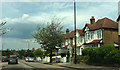
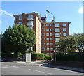
You are entering a distinct market segment when purchasing homes in SE9 1UA. The area is defined by a stark contrast to new-build developments, focusing instead on established residential clusters. With 53% of residents being homeowners, the stock is predominantly owner-occupied rather than a high-turnover rental community. The predominant accommodation type is flats, meaning you will mostly encounter apartment living within this specific postcode. This structure suggests a gridiron or terraced layout typical of historic London suburbs rather than sprawling detached family homes. The high home ownership rate implies that the residents are invested in the long-term value of their addresses. They are not waiting for the next rent hike but are protecting their equity. When viewing properties, expect to find second-hand flats that have evolved over decades alongside the area's history. The local market moves at a different pace than areas dominated by student housing or private landlords. Buyers here compete for existing stock rather than chasing speculative new builds. The character of the area supports a stable property investment because the resident base takes a long-term view.
House Prices in SE9 1UA
No properties found in this postcode.
Energy Efficiency in SE9 1UA
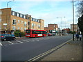
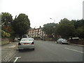
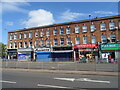
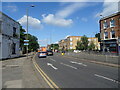
Daily life in SE9 1UA revolves around practical amenities within easy reach. For your shopping needs, Sainsburys Eltham, Lidl Eltham, and M&S Eltham are located nearby, forming a dependable retail triangle. These major supermarkets ensure you have access to groceries, household essentials, and dining options without a prolonged commute. Five notable rail stations serve the broader neighbourhood, including Eltham, Mottingham Station, and New Eltham. This network gives you the flexibility to combine tube travel with train services depending on your destination. Beyond shopping and trains, the area offers diverse transport options. The Lamorbey Eltham trolley bus (King George V.) and Elverson Road circumferential bus routes provide local mobility. You also have access to Woolwich Arsenal Pier and Woolwich Ferry North Pier for river crossings. For business travel, London City Airport and its metro links are practically accessible. The retention of Eltham Palace as a landmark adds cultural depth to the living experience. This mix of historic openness and modern connectivity defines the character of the area.
Amenities
Schools
Families living in SE9 1UA benefit from direct access to two major educational institutions nearby. The nearest provision is St Thomas More Roman Catholic Comprehensive School, which also operates as an academy. This institution holds a 'good' Ofsted rating, providing assurance of educational standards according to government inspectors. The naming convention appears slightly varied in records, with one entry listed as St Thomas More Catholic Comprehensive School, but both refer to the same educational entity serving the local catchment. This mix of school types means you have access to state-funded comprehensive education without the need to travel further afield. The presence of a maintained school with academy status suggests a blend of local governance and autonomous operation. A primary education option is noted as St Thomas More Roman Catholic Comprehensive School, indicating that the institution might serve younger pupils or that the surrounding area relies heavily on this single comprehensive for diverse age groups. For families prioritising faith-based education within a good rating framework, these facilities offer a clear choice. There are no private institutions listed in the immediate data, meaning the local education landscape relies entirely on the state system.
| Rank | School | Type | Entry gender | Ages |
|---|
Explore more schools in this area
Go to Schools tabDemographics
The community in SE9 1UA reflects a mature demographic profile with significant stability. The median age across the cluster stands at 47 years, indicating a resident base composed largely of older adults. Data confirms that adults aged 30 to 64 years constitute the most common age range, suggesting a population that values established surroundings over youthful vibrancy. You are looking at an area where long-term residents likely shape the local culture and community decisions. Home ownership levels reveal a settled population with 53% of households owning their property outright or with a mortgage. This majority indicates a strong preference for staying put rather than chasing new developments. The predominant accommodation type in this small postcode is flats, which aligns with the urban character of Eltham Town. The area remains predominantly populated by White residents, consistent with the wider demographic trends of the borough. While most people live here, the specific mix of flat ownership versus detached homes suggests a density typical of established suburban estates. This demographic mix supports a quieter neighbourhood atmosphere compared to areas with a younger, transient population.
Household Size
Accommodation Type
Tenure
Ethnic Group
Religion
Household Composition
Age
Household Deprivation
NS-SEC
Explore more demographic insights in this area
Go to Demographics tabPlanning
Planning Constraints
- Flood RiskPremium
- Ramsar Wetland SitesPremium
- Area of Outstanding Natural BeautyPremium
- Protected Nature ReservePremium
- Protected WoodlandPremium