Area Overview for SE9 1TT
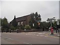
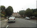
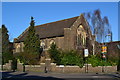
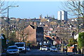
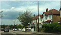
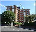
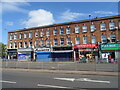
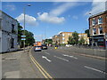
Photos of SE9 1TT
Area Information
SE9 1TT is a specific residential postcode located within the wider Eltham Town and Avery Hill ward in the Royal Borough of Greenwich. This small cluster covers only 619 square metres and is home to 1,688 people. You are looking at an area situated approximately 8.7 miles east-southeast of Charing Cross. The location straddles the boundary between a developed town centre and the green spaces of Avery Hill. Residents live in an environment where urban convenience meets historical significance, with the nearby Avery Hill Mansion grounds and Eltham Palace serving as key landmarks. The area retains a suburban character despite its proximity to major transport links and the city. Human activity in the broader vicinity dates back to the Mesolithic period, evidenced by finds in the local park, though the current built environment is largely a product of later centuries. When considering homes in this postcode, you are selecting a residence with deep historical roots yet modern connectivity. The density is high given the small land area, suggesting a compact living arrangement typical of this specific cluster. You gain access to a neighbourhood that has evolved from civil parish to a modern borough, blending heritage with everyday life. Living here means being close to the Downs while enjoying direct links to wider London.
- Area Type
- Postcode
- Area Size
- 619 m²
- Population
- 1688
- Population Density
- 5021 people/km²
Homes in SE9 1TT consist primarily of houses, making it a residential area focused on traditional family accommodation rather than flats or apartments. The market is significantly owner-occupied, with 56 per cent of residents owning their homes. This high level of ownership suggests that the area attracts buyers who intend to stay longer term. You will find a stock of properties that serves a mature demographic, given that the median age of residents is 47 years. The accommodation type data confirms that houses are the standard building form here. While the specific postcode covers a small footprint of 619 square metres, the surrounding Eltham Town and Avery Hill ward offers a wider variety of housing options. The concentration of house ownership means that rental properties may be fewer in number compared to denser urban zones. For those seeking a house to buy, this area offers suitability for families and established professionals. The property market reflects the suburban character of the neighbourhood, prioritising front-garden access and residential stability. There is less variety in building type compared to zones dominated by high-rise blocks or purpose-built apartment towers.
House Prices in SE9 1TT
No properties found in this postcode.
Energy Efficiency in SE9 1TT
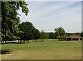
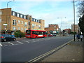
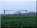
Living in SE9 1TT provides practical access to a wide range of amenities within easy reach. You have five retail outlets available, including Lidl Eltham, Sainsburys Eltham, and M&S Eltham, covering your daily grocery and shopping needs. The rail network offers five key stations, including Eltham, Mottingham Station, and New Eltham, ensuring straightforward travel connections. Five ferry terminals, such as Woolwich Arsenal Pier and Woolwich Ferry North Pier, provide alternative water-based routes into the city. The metro network includes access points like Elverson Road, King George V, and Cutty Sark for Maritime Greenwich for those seeking Diamond Jubilee Line travel. London City Airport sits nearby, offering options for private or business travel. Beyond transport links, the area is bordered by significant green spaces. Avery Hill Park contains the Winter Garden with Britain's largest Canary date palm and Henley's Field, a wild flower meadow. You can walk to Eltham Palace for historical interest. This mix of retail variety and open parkland creates a balanced lifestyle where you can shop locally and enjoy nature.
Amenities
Schools
Families living in SE9 1TT benefit from access to Eltham Church of England Primary School, which is located nearby. This institution is registered as a primary school and carries an Ofsted rating of good. The presence of a rated primary school within practical reach supports children in the 30-64 age bracket who may have school-aged children in their household. This specific school name and positive rating provide concrete information for parents researching education options. No secondary schools are listed in the provided data for this immediate cluster, but the primary facility serves the early years educational needs. The good rating indicates that the school meets established standards for education and safety. When considering schools near SE9 1TT, this primary option is the key facility referenced for the area. The single school entry suggests a localized catchment area or a need to look to the wider Eltham ward for secondary education. You can rely on the documented good standard when evaluating educational provisions for your family.
| Rank | School | Type | Entry gender | Ages |
|---|
Explore more schools in this area
Go to Schools tabDemographics
The community in SE9 1TT is defined by a mature population with a median age of 47 years. Adults between the ages of 30 and 64 represent the most common age range in the area. This demographic profile suggests a district settled by families and established professionals rather than a hub for students or young couples. Home ownership stands at 56 per cent, indicating that more than half of the residents own their property outright or with a mortgage. The remaining 44 per cent of residents rent their homes. Accommodation is predominantly houses, reflecting the residential nature of the postcode rather than apartment living. The predominant ethnic group is White, which aligns with the broader demographic trends of the surrounding Greenwich borough. With a population density of 2,725,930 people per square kilometre calculated for the site, the area feels populated without being oversized. These figures present a clear picture of a stable community where long-term residents have established roots. The high percentage of owner-occupiers often points to a quieter environment where residents have been living in their properties for extended periods. You are joining a neighbourhood where the majority of households have a stake in the area's stability.
Household Size
Accommodation Type
Tenure
Ethnic Group
Religion
Household Composition
Age
Household Deprivation
NS-SEC
Explore more demographic insights in this area
Go to Demographics tabPlanning
Planning Constraints
- Flood RiskPremium
- Ramsar Wetland SitesPremium
- Area of Outstanding Natural BeautyPremium
- Protected Nature ReservePremium
- Protected WoodlandPremium