Area Overview for SE6 2SS
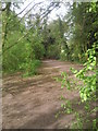
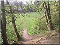
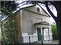
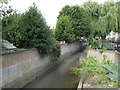
Photos of SE6 2SS
Area Information
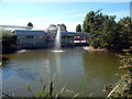
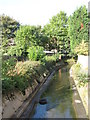
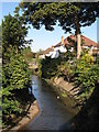
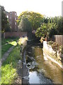
Living in SE6 2SS means residing in a small residential cluster located within the Catford South ward of the London Borough of Lewisham. The postcode covers just 2348 square metres, housing a population of 1788 people. This specific area forms part of the administrative centre for Catford, situated southwest of Lewisham near the River Ravensbourne. Residents enjoy a position defined as a unitary ward established in 2002, providing a slice of suburban urban life characterised by non-chain eateries and cultural events. The character of the environment includes notable features such as the Catford Broadway street market and Mountsfield Park. History here is deep, with the name Catford first recorded in 1254, referencing a ford across the river frequented by wild cats. While the wider district saw railway arrival in 1857 and extensive redevelopment, SE6 2SS offers a compact pocket of this evolution. You are positioned close to the South Circular road and benefit from practical proximity to shop front retailers like Tesco Bellingham. The day-to-day experience involves a blend of historic river-side context and modern suburban convenience. This small footprint creates a distinct community feel compared to the broader borough.
- Area Type
- Postcode
- Area Size
- 2348 m²
- Population
- 1788
- Population Density
- 5531 people/km²
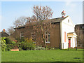
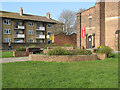
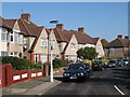
Homes in SE6 2SS are predominantly houses, supporting the area's character as a residential cluster within Catford South. With 57% home ownership, the market leans towards owner-occupiers rather than part-time or specialist landlords. This high ownership rate suggests a community driven by long-term residents rather than transient tenants. The accommodation type data confirms that houses form the backbone of this suburb, offering the space and garden access often associated with this property style. For buyers looking at this small postcode, the odds favour finding freehold properties over leasehold flats. The concentration of houses means the streetscape is likely defined by detached or semi-detached structures typical of suburban London development. This housing stock supports the demographic of adults in their thirties and forties who have settled down. The mix of owner-occupied homes indicates a stable property market with relatively low turnover compared to dense rental zones.
House Prices in SE6 2SS
No properties found in this postcode.
Energy Efficiency in SE6 2SS
Daily life in SE6 2SS benefits from immediate access to a range of amenities within practical reach. For shopping, you can visit five retail locations including Tesco Bellingham, Co-op Bellingham, and M&S Downham Bromley BP. Public transport is highly accessible, with five railway stations and five metro stops nearby. Key rail hubs include Bellingham Station and Beckenham Hill Station, while the Brighton Main Line and Docklands Light Railway provide extensive connectivity. Leisure and travel options expand through the presence of five ferry piers, including Greenwich Pier and Masthouse Terrace Pier. London City Airport sits approximately one mile away, offering direct flights to key European destinations. These facilities mean you do not need to travel far for food, travel, or commute. The area's location within Catford South Ward connects you to the larger cultural offerings of the district, including the Catford Broadway street market and Mountsfield Park. Living here provides a convenient balance between residential quiet and urban convenience.
Amenities
Schools
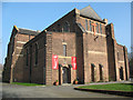
Families considering homes in SE6 2SS have access to education provided by Conisborough College. The school operates under two designations within the data, functioning as both a primary institution and an academy. This dual structure allows for continuity in educational provision within the local cluster. While Ofsted ratings are not explicitly detailed in the current records, the presence of an academy status indicates alignment with national standards and government oversight. The availability of a single college serving both early years and secondary needs suggests a coordinated local education strategy. For residents, this means children may transition through different phases of the same institution or benefit from a dedicated local focus. The nearest educational facility named is Conisborough College, which serves the immediate needs of students living in this small postcode area. Parents looking for schools near SE6 2SS should look at this specific establishment as their primary option. The academy model often implies a broader curriculum and potential for greater school governance autonomy.
| Rank | School | Type | Entry gender | Ages |
|---|
Explore more schools in this area
Go to Schools tabDemographics
The community within SE6 2SS reflects a mature demographic profile, with a median age of 47 years. Adults aged between 30 and 64 years constitute the most common age range in the area. This age distribution aligns with the broader character of Catford, where the average resident age is recorded as 38 years, slightly older than the London average of 37. Home ownership stands at 57%, indicating a significant portion of residents own their homes outright. The accommodation type primarily consists of houses, distinguishing this cluster from areas dominated by flats. Ethnic diversity is also notable, with the black_total group identified as the predominant ethnic group. These figures suggest a settled neighbourhood where many residents have long-term ties to the locality. The higher rate of home ownership often correlates with families who have chosen to stay in one area for extended periods. This stability contributes to a neighbourhood where residents understand the local history and community dynamics intimately.
Household Size
Accommodation Type
Tenure
Ethnic Group
Religion
Household Composition
Age
Household Deprivation
NS-SEC
Explore more demographic insights in this area
Go to Demographics tabPlanning
Planning Constraints
- Flood RiskPremium
- Ramsar Wetland SitesPremium
- Area of Outstanding Natural BeautyPremium
- Protected Nature ReservePremium
- Protected WoodlandPremium