Area Overview for SE6 1RH
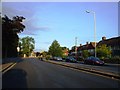
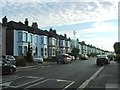
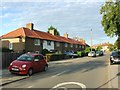
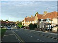
Photos of SE6 1RH
Area Information
SE6 1RH represents a small residential cluster within the wider historic district of Hither Green, located in the London Borough of Lewisham. This specific postcode area serves a population of 1,551 people, creating a tightly knit neighbourhood where residents often know one another. The district holds a distinct geographical claim to fame; the Prime Meridian crosses directly through the pedestrian tunnel at Hither Green Station, meaning most of the immediate surroundings lie in the western hemisphere. You are living in an area that transformed from a rural hamlet called Romborough into a suburban community following the opening of the railway station in 1895. The location offers a quiet residential atmosphere characterised by late Victorian and Edwardian architecture, particularly on the Corbett Estate. Daily life here is defined by its proximity to significant transport links and established parks like Mountsfield Park. While the immediate vicinity of SE6 1RH remains residential, the character of Hither Green blends domestic stability with access to broader London connectivity. The area sits near the Great North Road, yet retains a sense of independence from the city centre bustle. Families value the space and the historical depth of their homes, many of which date back to the development boom of the late 19th century. Whether you are looking at homes in SE6 1RH or exploring nearby streets, the architecture tells a story of a developer, Archibald Cameron Corbett, who planned a substantial estate with specific Anabaptist and temperance influences. This legacy means you might find fewer public houses than in typical London suburbs, reflecting the original developer's convictions about sobriety. The area is situated where the rivers Quaggy and Ravensbourne converge, adding a natural element to the suburb's appeal without compromising its convenient location.
- Area Type
- Postcode
- Area Size
- Not available
- Population
- 1551
- Population Density
- 10907 people/km²
The property market in SE6 1RH is defined by its status as a predominantly owner-occupied sector. With 74 per cent of households owning their homes, the area functions more as a heritage of established residents than a fluctuating rental marketplace. The accommodation type data confirms that houses are the standard housing stock, meaning you can expect terraced, semi-detached, or detached properties rather than flats or maisonettes. This architectural consistency stems from the Corbett Estate development begun in 1896, which established the housing typology for the district. Buyers looking at homes in SE6 1RH are entering a market where stability is the norm, driven by a population that invested in these properties decades ago. The small size of this postcode cluster means that listings will be rare and competitive when they do appear. There are no luxury towers or modern conversions here; the value lies in the original character of the late Victorian and Edwardian homes. This lack of high-density housing often results in more generous garden spaces compared to inner-city equivalents. If you are interested in property in SE6 1RH, you must act quickly, as the balance between buyers and sellers tilts heavily toward the former due to the low rental competition. The absence of major new builds in the immediate vicinity ensures that the streetscape retains its historical integrity. Your purchase will be of a substantial period property, likely requiring maintenance typical of buildings almost a century old. This market niche appeals to those who value specific architectural features over modern amenities.
House Prices in SE6 1RH
No properties found in this postcode.
Energy Efficiency in SE6 1RH
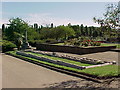
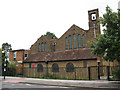
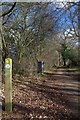
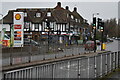
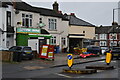
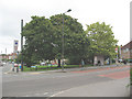
Residents of SE6 1RH enjoy a retail network clustered just beyond the immediate doorstep. Five retail locations operate within practical reach, headlined by Co-op Catford, Morrisons Daily, and Budgens Catford. These supermarkets and convenience stores are located near the main road arteries, allowing you to run errands without deep penetration into the residential lanes. Dining options are limited within the immediate tiny cluster, but the wider Hither Green area compensates with several eateries along Staplehurst Road and Hither Green Lane. Leisure and open space are significant highlights for this neighbourhood. Mountsfield Park is the central green space, opened in 1905 and covering 28 acres. This park includes the grounds of the former Mountsfield house and expanded to incorporate Charlton Athletic's former football ground in 1923. You can find St Andrew's Church on the estate, originally donated by Corbett, serving the community since its dedication. Further leisure options exist nearby, such as Manor House Gardens to the west and the extensive Manor Park to the east. For those who enjoy water, the area sits near the Quaggy and Ravensbourne, providing scenic walks. While there are no public houses due to Corbett's temperance beliefs, the variety of parks and shops ensures a balanced lifestyle without the noise of a traditional high-street bar scene.
Amenities
Schools
| Rank | School | Type | Entry gender | Ages |
|---|
Explore more schools in this area
Go to Schools tabDemographics
The community within SE6 1RH displays a mature profile, with a median age of 47 years. The majority of residents fall into the thirty to sixty-four-year-old bracket, indicating a population that has settled down rather than chasing a transient lifestyle. You are likely to find a neighbourhood where adults balance career establishment with raising children or enjoying retirement, rather than a hub for young professionals or students. This steady demographic supports local services and creates a stable environment for long-term living. Home ownership stands at an impressive 74 per cent, suggesting that the vast majority of residents have built equity over time rather than renting. This high rate of ownership typically correlates with community involvement and lower transient rates. The accommodation type in this postcode is dominated by houses, offering detached, semi-detached, or terrace options typical of the area's suburban evolution. You will not find high-rise blocks or dense social housing projects within this cluster; instead, the streets are lined with the domestic architecture of the Edwardian era. The predominant ethnic group is White, which aligns with the historical development of the Corbett Estate by Scottish developers. This demographic composition reflects the area's origins as a planned suburban expansion rather than a naturally evolved village centre. For those considering schools near SE6 1RH, the family-friendly age profile suggests established demand for local education. The residential nature of the area ensures that noise levels remain moderate, ideal for households with older children or empty nesters seeking a quiet retreat from central London traffic.
Household Size
Accommodation Type
Tenure
Ethnic Group
Religion
Household Composition
Age
Household Deprivation
NS-SEC
Explore more demographic insights in this area
Go to Demographics tabPlanning
Planning Constraints
- Flood RiskPremium
- Ramsar Wetland SitesPremium
- Area of Outstanding Natural BeautyPremium
- Protected Nature ReservePremium
- Protected WoodlandPremium