Area Overview for SE5 7EN
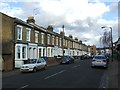
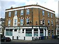
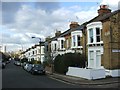
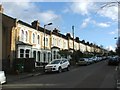
Photos of SE5 7EN


Area Information
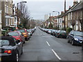
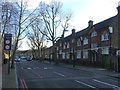
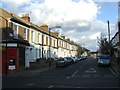
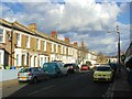
Living in SE5 7EN offers a specific experience within a small residential cluster covering just 2955 square metres. You are entering a dense environment where 1684 people reside in a highly compact footprint, resulting in a population density of 569913 people per square kilometre. This high density defines the daily rhythm of the postcode, creating an intensely urban atmosphere where proximity is the primary planning principle. The area functions as a focused node rather than a sprawling neighbourhood, meaning your immediate surroundings are filled with the energy of many households packed into limited space. Residents here experience life in a setting that prioritises accessibility over open space. The sheer concentration of people means that community noise and activity levels are always present. You are buying into a character defined by its intensity and location rather than traditional suburban features like private gardens or quiet streets. The area serves as a specific cluster within the broader London fabric, offering a straightforward, high-density living arrangement. Understanding this scale is essential before bringing permanent belongings into any home within this postcode boundary. The reality is that you will live amidst a significant number of neighbours in a very confined geographical zone. This setup suits those who value being close to everything but may feel overwhelming for those seeking spaciousness.
- Area Type
- Postcode
- Area Size
- 2955 m²
- Population
- 1684
- Population Density
- 16099 people/km²
The property market in SE5 7EN is characterised by a high concentration of Houses, yet this does not guarantee a large stock of owner-occupied dwellings. With only 23% of residents owning their homes, the area operates primarily as a rental market. You are more likely to find tenancies than to find a seller who has built equity over decades. This low home ownership rate often reflects the high density and the intense competition for housing in this small 2955 square metre zone. Because the accommodation type is predominantly Houses, the physical structures may appear as traditional buildings, but the tenure remains largely with landlords and letting agencies. You will not find a sea of 'For Sale' signs that indicate a stable, owner-occupied community in the traditional sense. Instead, you encounter a fluid market where occupants change more frequently than in suburban areas with higher ownership rates. The fact that 77% of residents do not own their homes means that security deposits and letting agent fees are more relevant factors for most households here than mortgage terms or long-term capital growth in a private equity context. For a buyer looking at this postcode, the reality is a market driven by demand from the 1684 residents living in close quarters. The limited area size constrains the total number of available properties, intensifying pressure on the rental sector. This dynamic suggests that if you are looking to purchase, you will face stiff competition from other investors or landlords seeking to add to their portfolios. The prevalence of Houses combined with low ownership creates a unique situation where the physical building type contradicts the typical profile of a family-friendly, long-term owner-occupied suburb. Prospective buyers mustnavigate a landscape where rentals dominate and property turnover is likely higher than average.
House Prices in SE5 7EN
Showing 1 properties
| Address | Type | Beds | Baths | Last Sale Price | Last Sale Date | |
|---|---|---|---|---|---|---|
| 267 Southampton Way, London, SE5 7EN | Semi-detached | - | - | - | - |
Energy Efficiency in SE5 7EN
Amenities in SE5 7EN place you within reach of essential services and leisure venues across the capital. For daily shopping, Sainsburys Camberwell, Tesco Southampton, and Lidl Peckham are all within practical range. These supermarkets provide comprehensive provisions for any household, from weekly groceries to household essentials. You can stock up on essentials without needing long weekend trips to the city centre. Your transport options are equally extensive. Rail travel is supported by Peckham Rye Station, Denmark Hill Station, and Queens Road Peckham Station, facilitating easy commutes across south London and the wider network. For quicker urban travel, Kennington Station and the Oval offer direct tube connections. If you prefer public buses, options include the Green Line Coach Station and London Victoria Coach Station, which assist with longer journeys. Aviation access is available via London City Airport, which sits nearby for business travellers or private flyers. Water transport adds variety to your daily routine. Ferry services link you to Wapping Pier, Tower Bridge Quay, and London Bridge City Pier, offering scenic routes across the river. This network of transport means you never have to rely on a single route for your daily life. The combination of local retail like Lidl and major transport arteries creates a convenient lifestyle where you can reach work, shop, or travel with minimal effort. Each major rail and tube station mentioned provides redundancy, ensuring that if one line is delayed, alternatives remain fully functional for your commute.
Amenities
Schools
| Rank | School | Type | Entry gender | Ages |
|---|
Explore more schools in this area
Go to Schools tabDemographics
The community in SE5 7EN is distinctly mature, with a median age of 47 years. The most common age range comprises adults between 30 and 64 years, indicating a neighbourhood populated primarily by working-age individuals who have likely established careers. This demographic profile suggests a population that may include young professionals and families with older children rather than teenagers or very young infants. Consequently, the local culture likely reflects the interests and energy levels of this mid-life demographic group. More than two-thirds of residents aged 65 and over are not living here, as the vast majority of the population falls within the prime adult years. This age distribution often correlates with specific lifestyle needs, such as access to reliable transport for commuting or proximity to local healthcare services. The area is overwhelmingly dominated by Houses, defining the architectural character of the local streetscape. However, with a home ownership rate of only 23%, the majority of these households are rented properties. This low ownership figure points toward a rental-led market where tenants make up nearly four-fifths of the population. Diversity is a defining feature of the local environment, with the Black population forming the predominant ethnic group. This demographic composition shapes the cultural flavour of SE5 7EN, influencing local shops, dining options, and community events. While specific data on deprivation is not provided in this dataset, the high density and low ownership rate often create a dynamic housing market. Buyers should expect a vibrant but densely packed community where social interactions happen frequently due to the limited physical space available to residents.
Household Size
Accommodation Type
Tenure
Ethnic Group
Religion
Household Composition
Age
Household Deprivation
NS-SEC
Explore more demographic insights in this area
Go to Demographics tabPlanning
Planning Constraints
- Flood RiskPremium
- Ramsar Wetland SitesPremium
- Area of Outstanding Natural BeautyPremium
- Protected Nature ReservePremium
- Protected WoodlandPremium