Area Overview for SE5 0YZ
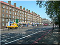
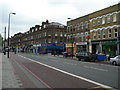
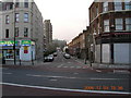
Photos of SE5 0YZ


Area Information
SE5 0YZ represents a small, tightly defined residential cluster within south London. You will find a population of 1,634 people concentrated in this specific postcode sector. This compact footprint means that daily life revolves closely around immediate local hubs rather than distant city centres. The area functions as a distinct pocket of accommodation where residents navigate a defined space between wider neighbourhoods like Camberwell and Stockwell. Because the zone covers such a small residential area, the sense of community is inherent to the geography rather than manufactured by marketing. You live in an environment where distances between key services are short, allowing for a pace of life that balances urban convenience with residential calm. The defining characteristic of this postcode is its concentration of flats, which shapes the architectural feel and the demographics of the street. When you consider a home here, you are entering a specific slice of London where the built environment and population density are carefully bounded. This focus on a particular postcode segment ensures that your view is not diluted by the sprawling nature of larger boroughs, offering a precise snapshot of urban living.
- Area Type
- Postcode
- Area Size
- Not available
- Population
- 1634
- Population Density
- 13766 people/km²
The housing market in SE5 0YZ is defined by a high concentration of flats, which dictates the type of properties available to you. Since 71% of the population does not own their home, the area functions largely as a rental sector rather than an owner-occupier zone. You should expect to find predominantly multi-unit buildings or blocks rather than detached houses or typical terraced family homes. This dominance of flats means that property sizes are generally compact, appealing to singles or couples who require less square footage. The low ownership rate of 29% suggests that land values and development pressure may keep purchase prices in a specific bracket compared to areas with high owner-occupier rates. If you are looking to buy, your focus must remain on leasehold flats located within this specific postcode boundary. The lack of single-family homes means you cannot find a garden or outside space as a standard feature. Instead, you compete in a market where proximity to transport links and amenities often drives value more than property size or traditional architectural features.
House Prices in SE5 0YZ
No properties found in this postcode.
Energy Efficiency in SE5 0YZ
Your lifestyle in SE5 0YZ benefits from a dense network of amenities located within practical striking distance of the postcode. You have access to five major retail outlets, including Co-op Camberwell, Iceland Camberwell, and Sainsburys Camberwell, ensuring your daily shopping needs are met without long journeys. For daily transport, five metro stations are nearby, including the Oval, Kennington Station, and Stockwell Station, offering direct Tube connections across the network. Rail travel is supported by five stations such as Elephant & Castle, Loughborough Junction, and Vauxhall Railway Station, expanding your travel options beyond the Underground. Additionally, five ferry piers like Vauxhall St George Wharf Pier and Lambeth Pier provide river waterways connectivity. You can also access three major bus locations, including the Green Line Coach Station and London Victoria Coach Station. This density of services means you do not need a car to navigate, dine, or run errands, making the area exceptionally convenient for a car-free existence.
Amenities
Schools
Families considering homes in SE5 0YZ will find one primary school option immediately nearby that holds a high rating. John Ruskin Primary School and Language Classes serves children in the immediate vicinity. The school holds an Ofsted rating of outstanding, which is the highest level of achievement possible in the English school system. This rating indicates strong performance in pupil progress, behaviour, and leadership within the institution. As this is the only listed school near the postcode, you will not have a broad choice of local primary providers for your children. The outstanding status makes this a significant advantage for buyers who prioritise education quality in their area selection. The school offers language classes, adding a educational dimension that might appeal to specific family needs. Parents will need to look beyond this single institution for secondary education, as no secondary schools are listed within the immediate data for this specific postcode area.
| Rank | School | Type | Entry gender | Ages |
|---|
Explore more schools in this area
Go to Schools tabDemographics
The community in SE5 0YZ is characterised by an older demographic profile compared to many parts of modern London. The median age sits at 47 years, indicating a mature population. The most common age range for residents falls within adults aged between 30 and 64 years, suggesting stability and long-term settlement. This age distribution influences the local demand for larger homes or ground-floor access, though the physical housing stock presents a specific constraint for these demographics. You will observe that 29% of homes in this postcode are owner-occupied, meaning the majority of residents are tenants. The predominant form of accommodation is the flat, which aligns with the higher proportion of renters and smaller household units. The population remains predominantly White, reflecting the historical and ongoing settlement patterns of south London. With fewer children residing here, the immediate social environment is likely quieter during weekdays. This profile means you are buying into an area where families with school-age children may be a minority, potentially reducing noise but also limiting certain community facilities that rely on higher population density across all age groups.
Household Size
Accommodation Type
Tenure
Ethnic Group
Religion
Household Composition
Age
Household Deprivation
NS-SEC
Explore more demographic insights in this area
Go to Demographics tabPlanning
Planning Constraints
- Flood RiskPremium
- Ramsar Wetland SitesPremium
- Area of Outstanding Natural BeautyPremium
- Protected Nature ReservePremium
- Protected WoodlandPremium