Area Overview for SE4 2QZ
Photos of SE4 2QZ
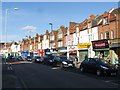
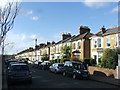
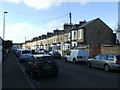
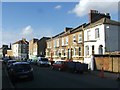
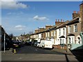
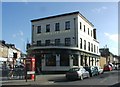
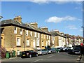
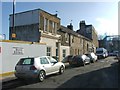
100 photos from this area
Area Information
Key information about the SE4 2QZ including its size, population, and administrative classification.
- Area Type
- Postcode
- Area Size
- 4367 m²
- Population
- 1994
- Population Density
- 13419 people/km²
House Prices in SE4 2QZ
37
Properties
£238,625
Average Sold Price
£120,000
Lowest Price
£392,500
Highest Price
Showing 37 properties
| Address | Type | Beds | Baths | Last Sale Price | Last Sale Date | |
|---|---|---|---|---|---|---|
| 325A Brockley Road, London, SE4 2QZ | Maisonette | 3 | - | £320,000 | Mar 2024 | |
| 329A Brockley Road, London, SE4 2QZ | Flat | - | - | £392,500 | Feb 2024 | |
| 307B Brockley Road, London, SE4 2QZ | Flat | - | - | £122,000 | Nov 2003 | |
| 331A Brockley Road, London, SE4 2QZ | Flat | - | - | £120,000 | May 2002 | |
| Flat Above, 323 Brockley Road, London, SE4 2QZ | Flat | - | - | - | - | |
| Second Floor Flat, 315 Brockley Road, London, SE4 2QZ | Flat | 2 | 1 | - | - | |
| 303B BROCKLEY ROAD, Crofton Park, London, SE4 2QZ | Flat | - | - | - | - | |
| Flat Above, 313 Brockley Road, London, SE4 2QZ | Flat | - | - | - | - | |
| 327A Brockley Road, London, SE4 2QZ | Flat | - | - | - | - | |
| 305B Brockley Road, London, SE4 2QZ | Flat | - | - | - | - |
Page 1 of 4
Energy Efficiency in SE4 2QZ
Amenities
Schools
| Rank | School | Type | Entry gender | Ages |
|---|
Explore more schools in this area
Go to Schools tabDemographics
Household Size
Family (3-5 people)
most common
Accommodation Type
Flats
most common
Tenure
50
majority
Ethnic Group
White
most common
Religion
N/A
most common
Household Composition
N/A
most common
Age
47
median
Adults (30-64 years)
most common
Household Deprivation
N/A
with no deprivation
NS-SEC
52
in Lower managerial occupations
Explore more demographic insights in this area
Go to Demographics tabPlanning
Planning Constraints
- Flood RiskPremium
- Ramsar Wetland SitesPremium
- Area of Outstanding Natural BeautyPremium
- Protected Nature ReservePremium
- Protected WoodlandPremium