Area Overview for SE22 9ZL
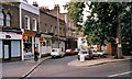
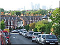
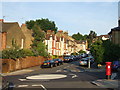
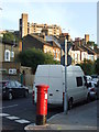
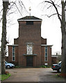
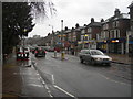
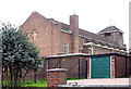
Photos of SE22 9ZL


Area Information
The postcode SE22 9ZL represents a tightly defined residential cluster in South East London. This specific location serves around 1,592 people, creating a compact neighbourhood where daily interactions are frequent and familiar. Living in SE22 9ZL means engaging with a community centred on houses rather than flats or high-rise blocks. The area functions as a stable residential hub rather than a commercial centre. Residents enjoy a quiet environment directly adjacent to established thoroughfares that link the area to broader transport networks. Your day-to-day life here revolves around proximity to major employment hubs while maintaining a local village feel. You are situated close to extensive rail, metro, and ferry connections that open up the rest of London. The neighbourhood is characterised by permanent residents who have put down roots rather than transient populations. This stability contributes to a predictable environment for families and professionals alike. Homes in SE22 9ZL are primarily houses, which defines the street aesthetics and noise levels. You do not live near any sensitive environmental constraints such as flood zones or protected woodlands. This geographical safety allows for straightforward planning and development within the immediate vicinity. The area sits comfortably within the London capital, balancing suburban tranquility with metropolitan access.
- Area Type
- Postcode
- Area Size
- Not available
- Population
- 1592
- Population Density
- 15747 people/km²
The property market in SE22 9ZL is defined by a strong presence of traditional homeownership. Sixty-four per cent of the population owns their homes outright or with a mortgage. This statistic indicates that the area is dominated by owner-occupiers rather than private landlords or housing associations managing rental stock. The predominant accommodation type consists of houses, which distinguishes this postcode from those containing significant portions of flats or terraced urban dwellings. Living in a market where houses predominate offers specific advantages for buyers seeking garden space and street-level privacy. The fact that two-thirds of residents own their properties suggests a community invested in local improvement and maintenance. You are unlikely to find large blocks of modern rental developments replacing traditional housing stocks. The housing stock consists mainly of standalone or semi-detached structures fitting a suburban model. This composition appeals to families requiring more floor space or privacy compared to apartment living. The area is not characterised by transient renting but by long-term settlement. Buyers looking at homes in SE22 9ZL enter a market where values are supported by permanent residents protecting their equity. The high ownership percentage often correlates with lower rental void periods and more stable interactions with neighbours.
House Prices in SE22 9ZL
No properties found in this postcode.
Energy Efficiency in SE22 9ZL
Lifestyle in SE22 9ZL benefits from immediate access to a diverse range of retail and transport amenities. Five retail locations serve the local shopping needs, including M&S Dulwich, Co-op Dulwich, and Tesco East. These superstores provide essentials within walking or short driving distance. You do not need to travel far to stock the cupboards or pick up fresh groceries. Transport options further enhance your daily convenience with five nearby rail stations, five metro stops, and five ferry piers. Landmarks like North Dulwich, Peckham Rye, and Stockwell stations integrate you into the wider London network. Leisure travel is supported by five ferry terminals including Masthouse Terrace Pier and Vauxhall St George Wharf Pier. Five bus hubs are available, highlighting the Victoria Coach Station and Green Line Coach Station. This extensive connectivity means you can reach major leisure destinations, riverside walks, or airport terminals efficiently. The area functions as a well-connected residential zone where services are located close by. You can combine a Sunday shop at M&S Dulwich with a day trip to Greenwich via the nearby rail or ferry links. The presence of multiple large retailers and diverse transport modes creates a self-sufficient environment without needing long commutes for basic needs. Daily life involves easy access to both local basics and regional attractions.
Amenities
Schools
Families considering schools near SE22 9ZL find Harris Primary Academy East Dulwich located in close proximity. This institution operates as a primary school and holds an outstanding Ofsted rating. The presence of this single listed school with top-tier accreditation indicates a high standard of primary education within immediate reach. The data provided explicitly details only this one educational facility with confirmed performance metrics. You have access to a primary school recognised for its excellence without needing to look further afield for initial education. The school mix in this specific postcode data reflects a focus on early years education. Parents can send their children to a primary school with verified outstanding standards before they might transition to secondary education later in childhood. The rating of outstanding provides a concrete measure of quality rather than a general assumption of good provision. Harris Primary Academy East Dulwich serves the immediate catchment needs for young children in the SE22 sector. There are no secondary schools listed in the provided data for this specific cluster, so families will need to consider options beyond the immediate primary catchment area as children age. The availability of an outstanding primary school is a significant asset for households in this residential zone.
| Rank | School | Type | Entry gender | Ages |
|---|
Explore more schools in this area
Go to Schools tabDemographics
The community within SE22 9ZL reflects a mature demographic profile with a median age of 47 years old. Most residents fall into the 30 to 64 years age range, indicating a population of adults who have typically retired from early career stages or are well-established parents. This age distribution contrasts with areas drawn by young professionals or student populations. You are living in an area where the primary occupants are middle-aged adults managing families on larger mortgages or drawing down savings. Home ownership stands at 64 per cent, demonstrating that the majority of households have purchased their properties rather than renting. This high ownership rate suggests stable, long-term residents who retain a strong attachment to their local streets. The predominant accommodation type is houses, which matches the preference of this adult demographic for space and garden access. White residents make up the predominant ethnic group within this postcode area. The demographic data paints a picture of a settled, middle-aged community focused on stability. You are joining a neighbourhood where neighbours likely grew up together or arrived decades ago. There are no indications of rapid population turnover or significant demographic shifts in this specific cluster. The social fabric here is defined by long residency and home ownership.
Household Size
Accommodation Type
Tenure
Ethnic Group
Religion
Household Composition
Age
Household Deprivation
NS-SEC
Explore more demographic insights in this area
Go to Demographics tabPlanning
Planning Constraints
- Flood RiskPremium
- Ramsar Wetland SitesPremium
- Area of Outstanding Natural BeautyPremium
- Protected Nature ReservePremium
- Protected WoodlandPremium