Area Overview for SE22 9JF
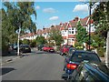
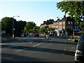
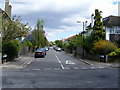
Photos of SE22 9JF


Area Information
Living in SE22 9JF defines a specific residential experience within South London. This postcode covers a small residential cluster characterised by stability and established housing. The area supports a population of 1,848 people, creating a close-knit rather than sprawling community.Residents here enjoy a balance of quiet domestic life and practical access to wider London connectivity. The demographic profile suggests a mature community, with the majority of residents falling into the adult age range between 30 and 64 years. This indicates a neighbourhood where families and professionals seek long-term stability. Daily life in this cluster is practical, supported by strong digital infrastructure and reliable public services. You will find the area free from significant environmental planning constraints such as protected woodlands or wetlands, ensuring straightforward living conditions. The housing stock is entirely composed of houses, which aligns with the high rate of home ownership found here. Whether you are looking for a single-family detached property or a terraced home within this postcode, the physical environment is consistent. The location serves as a solid base for those who value ownership and established neighbourhoods over transient market offerings.
- Area Type
- Postcode
- Area Size
- Not available
- Population
- 1848
- Population Density
- 16000 people/km²
The property market in SE22 9JF is heavily weighted towards home ownership, with 59% of households owning their property. This statistic paints a clear picture of a neighbourhood where residents typically stay put until they move up the property ladder or relocate entirely. The accommodation type data confirms that the housing stock consists solely of houses, meaning you will not find flats or maisonettes within this specific postcode boundary. This composition creates a residential market distinct from inner-city regeneration zones or student lettings corridors. When looking at homes in SE22 9JF, you are entering an established market where owners have invested in their properties over a long period. The lack of rental_stock implies that investment yields are driven by capital appreciation rather than high turnover from external landlords. This environment suits buyers seeking a traditional household setting rather than a transient lifestyle. The fact that the entire cluster is built of houses also means planning constraints related to high-density developments are unlikely to affect immediate local character. For those prioritising stability and established landscaping, this area offers a secure entry point into the housing market.
House Prices in SE22 9JF
No properties found in this postcode.
Energy Efficiency in SE22 9JF
Residents of SE22 9JF benefit from immediate access to a range of retail and transport amenities that are within practical reach. For everyday shopping needs, you can visit Sainsburys London, M&S Dulwich, or the Co-op Dulwich, all listed as notable retail options nearby. These venues ensure that routine household shopping and dining decisions remain simple without requiring a significant commute. Transport links are extensive, offering flexibility for commuters. Five train stations are accessible, including North Dulwich, Peckham Rye Station, and West Dulwich. If the train is not your preference, five Metro stations such as Stockwell Station, Oval, and Deptford Bridge provide alternative routes. For scenic travel or riverside access, seven ferry piers are available, including Vauxhall St George Wharf Pier and Greenland Surrey Quays Pier. You also have access to three major coach stations, including Green Line Coach Station and Victoria Coach Station. This density of transport options means you can choose a route that suits your schedule or mood, whether that involves a short walk to a train platform or a leisurely bus ride.
Amenities
Schools
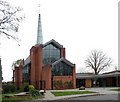
Families considering homes in SE22 9JF have access to Heber Primary School, which serves as the key educational institution in the immediate vicinity. This primary school holds an Ofsted rating of 'good', a designation that signals consistent quality in education and student care. For residents with school-aged children, this specific rating provides tangible reassurance regarding the standard of teaching available. The school data for this area does not list any secondary schools or nursery facilities directly adjacent to the postcode, placing Heber Primary School as the singular notable option in the provided records. This means families in SE22 9JF likely rely heavily on this one school for early education before transferring to secondary institutions further away. The presence of a school rated 'good' supports the demographic finding that a significant portion of the 47-year-old median age group consists of parents involved in primary education. While the data does not show a mix of private, academy, or maintained schools in this immediate cluster, the singular quality rating of Heber provides a strong foundation for families moving to this cluster.
| Rank | School | Type | Entry gender | Ages |
|---|
Explore more schools in this area
Go to Schools tabDemographics
The community in SE22 9JF is defined by maturity and stability. The median age stands at 47 years, reflecting a population that has settled rather than constantly moving on. Most residents are adults between the ages of 30 and 64 years, meaning children and retirees form a smaller slice of the demographic cake compared to the working-age professionals. This age distribution suggests a family-oriented or 'empty nester' environment where neighbours know one another. Home ownership is the dominant housing tenure in this postcode. A total of 59% of households own their homes outright or have a mortgage. This figure is significantly higher than many private postcodes in London, indicating that investors and short-term rentals are less common here. The majority of the population identifies as White, maintaining the traditional character often associated with older South London residential clusters. The accommodation type is exclusively houses, which supports the higher rate of ownership compared to high-density rental estates. You will encounter a relatively uniform community where long-term residents have shaped the local culture over decades rather than years.
Household Size
Accommodation Type
Tenure
Ethnic Group
Religion
Household Composition
Age
Household Deprivation
NS-SEC
Explore more demographic insights in this area
Go to Demographics tabPlanning
Planning Constraints
- Flood RiskPremium
- Ramsar Wetland SitesPremium
- Area of Outstanding Natural BeautyPremium
- Protected Nature ReservePremium
- Protected WoodlandPremium