Area Overview for SE20 8ET
Photos of SE20 8ET

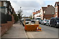
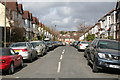
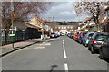


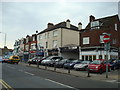

100 photos from this area
Area Information
Key information about the SE20 8ET including its size, population, and administrative classification.
- Area Type
- Postcode
- Area Size
- 1.2 hectares
- Population
- 1665
- Population Density
- 7213 people/km²
House Prices in SE20 8ET
63
Properties
£555,956
Average Sold Price
£80,000
Lowest Price
£855,000
Highest Price
Showing 63 properties
| Address | Type | Beds | Baths | Last Sale Price | Last Sale Date | |
|---|---|---|---|---|---|---|
| 4 Stodart Road, Penge, London, SE20 8ET | house | 6 | 1 | £850,000 | Aug 2025 | |
| 8 Stodart Road, Penge, London, SE20 8ET | Maisonette | 3 | 2 | £430,000 | Jul 2024 | |
| 27 Stodart Road, Penge, London, SE20 8ET | Semi-detached | 4 | 1 | £850,000 | Mar 2024 | |
| 16A Stodart Road, Penge, London, SE20 8ET | Maisonette | 2 | 1 | £352,000 | Mar 2024 | |
| 22 Stodart Road, Penge, London, SE20 8ET | Detached | 3 | 1 | £750,000 | Aug 2023 | |
| 13 Stodart Road, Penge, London, SE20 8ET | Semi-detached | 3 | 1 | £825,000 | Nov 2022 | |
| 3 Stodart Road, Penge, London, SE20 8ET | Semi-detached | 3 | 1 | £855,000 | Aug 2022 | |
| 30 Stodart Road, Penge, London, SE20 8ET | Semi-detached | 3 | 1 | £740,000 | Mar 2021 | |
| 7 Stodart Road, Penge, London, SE20 8ET | Semi-detached | 4 | 1 | £807,500 | Feb 2021 | |
| 18 Stodart Road, Penge, London, SE20 8ET | Semi-detached | 3 | - | £735,000 | Nov 2020 |
Page 1 of 7
Energy Efficiency in SE20 8ET
Amenities
Schools
| Rank | School | Type | Entry gender | Ages |
|---|
Explore more schools in this area
Go to Schools tabDemographics
Household Size
One person
most common
Accommodation Type
Flats
most common
Tenure
39
majority
Ethnic Group
White
most common
Religion
N/A
most common
Household Composition
N/A
most common
Age
47
median
Adults (30-64 years)
most common
Household Deprivation
N/A
with no deprivation
NS-SEC
40
in Lower managerial occupations
Explore more demographic insights in this area
Go to Demographics tabPlanning
Planning Constraints
- Flood RiskPremium
- Ramsar Wetland SitesPremium
- Area of Outstanding Natural BeautyPremium
- Protected Nature ReservePremium
- Protected WoodlandPremium