Area Overview for SE17 1AU
Photos of SE17 1AU


Area Information
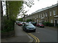
Living in SE17 1AU means residing within a specific postcode cluster in south London that defines a small residential community of 1,545 people. This compact area sits firmly within the London Borough of Southwark, offering a distinct urban experience characterised by close proximity to major transport hubs. The density of the neighbourhood creates an environment where daily errands and local interactions feel immediate, yet the location remains integrated with wider London connectivity. Residents benefit from being surrounded by three major railway stations, allowing quick access to the capital's financial district and business corridors without the isolation often found in peripheral districts. The area functions as a practical residential base rather than a sprawling suburb, catering to those who prioritise access to amenities over vast green spaces or low population density. Understanding the scale of SE17 1AU helps buyers frame their expectations correctly regarding noise levels, shared facilities, and local community dynamics. It is an established part of south London where the rhythm of life is dictated by proximity to transport links and the surrounding city fabric. Prospective buyers seeking a straightforward introduction to south London housing will find the character of this postcode reflected in its neighbours and the immediate streetscape.
- Area Type
- Postcode
- Area Size
- Not available
- Population
- 1545
- Population Density
- 20065 people/km²
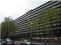
The property market in SE17 1AU is defined by a sharp divergence from traditional south London suburbs. With home ownership at just 29%, this postcode operates predominantly as a rental market rather than a space for first-time buyers to establish long-term tenure. The dominant accommodation type is flats, which cater to tenants seeking flexible contracts and those requiring lower maintenance responsibilities compared to houses. This high concentration of rental properties implies that much of the housing stock consists of purpose-built blocks or conversions rather than single-family homes. Buyers looking at SE17 1AU must recognise that purchasing here often involves acquiring a flat within a block of similar units, where management is typically handled by a managing agent or community management company. The low ownership rate reduces the likelihood of finding a detached house or semi-detached property in this specific cluster. Consequently, the market here appeals more strongly to investors and landlords than to owner-occupiers seeking to build generational wealth through property equity. The fabric of the neighbourhood reflects this reality, with fewer gardens and more communal stairwells or lifts characterising the built environment.
House Prices in SE17 1AU
No properties found in this postcode.
Energy Efficiency in SE17 1AU
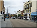
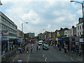
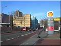
Daily life in SE17 1AU is defined by immediate access to major retail and travel hubs. Residents have five retail options nearby, including Tesco Southwark, Morrisons Walworth, and the Co-op Kennington, ensuring groceries and essential shopping are within easy reach. The same transport convenience extends to leisure and travel, with five rail stations like Elephant & Castle and London Bridge in close proximity. Five metro stations, including Kennington and Oval, provide comprehensive tube coverage directly integrated into the local streetscape. Commuting further afield is supported by three ferry locations such as Lambeth Pier and Millbank Pier, alongside three bus routes connecting to Victoria Coach Station and the Green Line network. This mix of transport modes allows residents to choose the most efficient route depending on their destination or preference. You can walk to your local Tesco or head towards London Bridge for work, all within a short journey. The presence of so many major amenities within practical reach means you do not need to drive to satisfy shopping or travel needs. The sheer volume of nearby stations and supermarkets creates a lifestyle where convenience is built into the geography of the postcode rather than requiring longer commutes or car dependency.
Amenities
Schools
| Rank | School | Type | Entry gender | Ages |
|---|
Explore more schools in this area
Go to Schools tabDemographics
The community in SE17 1AU reflects the broader middle-aged South London population, with a median age of 47 years. Adults between the ages of 30 and 64 years form the most common age range, indicating a neighbourhood where families and established professionals often reside. This demographic profile suggests stability within the local housing stock, as residents are less likely to be transient students or young renters. The area is predominantly white in terms of ethnicity, though London's diverse population influences the cultural landscape of the wider borough. Home ownership stands at 29% within this postcode, meaning roughly seven out of every ten homes are rented. This high rental proportion is closely tied to the local accommodation type, which consists mainly of flats. The prevalence of flats aligns with the age profile, catering to families and professionals who require compact, efficiently designed living spaces rather than detached houses. These housing characteristics create a landlord market where security of tenure can differ from owner-occupied areas. Understanding that most residents rent provides context for local governance and who ultimately benefits from neighbourhood improvements or regeneration projects in SE17 1AU.
Household Size
Accommodation Type
Tenure
Ethnic Group
Religion
Household Composition
Age
Household Deprivation
NS-SEC
Explore more demographic insights in this area
Go to Demographics tabPlanning
Planning Constraints
- Flood RiskPremium
- Ramsar Wetland SitesPremium
- Area of Outstanding Natural BeautyPremium
- Protected Nature ReservePremium
- Protected WoodlandPremium