Area Overview for SE10 9FA
Photos of SE10 9FA


Area Information
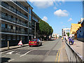
Living in SE10 9FA means residing in a compact residential cluster with a distinct urban character. This specific postcode covers a population of 1,813 people, creating a tight-knit environment where neighbours often know one another. The community is heavily influenced by its proximity to key transport hubs and the historic maritime district nearby. Daily life here revolves around a mix of modern convenience and established connectivity, making it a practical choice for professionals working in central London. Residents enjoy rapid access to major railway stations and the DLR, ensuring that commuting to Greenwich, London Bridge, or further afield is efficient. The area benefits from a streamlined layout designed around accessibility rather than sprawling density. You can expect a lived-in atmosphere where the rhythm of the day is set by the movement of trains and buses. For those seeking a home close to the action without the congestion of the city centre, this cluster offers a straightforward living situation. The location serves as a gateway to wider opportunities, balancing urban pace with manageable neighbourhood scales. It is an area defined by its function and proximity to the city, appealing to people who value transport links above all else.
- Area Type
- Postcode
- Area Size
- Not available
- Population
- 1813
- Population Density
- 25923 people/km²
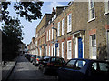
Homes in SE10 9FA are primarily flats, a structure that reflects the dynamic nature of the local property market. Only 26% of households own their homes, indicating that the vast majority of this postcode serves the rental sector or serves as a first-home ladder for young buyers. This high proportion of rental accommodation suggests a market driven by transient populations, students, and professionals on temporary contracts. For anyone looking to purchase a property here, you are entering a competitive environment where flats command attention due to their accessibility and lower entry costs compared to suburban houses. The housing stock is designed for efficiency, maximising limited space to accommodate the highest number of residents. This small residential cluster does not offer the variety of dwelling types found in larger postcodes, so buyers must adapt their preferences accordingly. Whether you are renting or planning to buy a flat, the demand remains steady given the area's strong transport links and proximity to employment hubs. Investors and landlords will find this area attractive due to the consistent turnover of tenancy.
House Prices in SE10 9FA
Showing 100 properties
Energy Efficiency in SE10 9FA
Residents of SE10 9FA enjoy immediate access to a wide array of amenities that support a convenient urban lifestyle. There are five retail options nearby, including reputable supermarkets such as Waitrose Greenwich, Tesco Cutty, and Sainsburys Greenwich. You can stock up on groceries without driving, saving valuable time in your weekly routine. For those who commute by rail, five rail stations are situated within practical reach, including the major hubs of Greenwich Station and Deptford. The Docklands Light Railway provides further connectivity, with Cutty Sark DLR Station and Cutty Sark for Maritime Greenwich serving as local stops. Water travel is also an option, with ferries departing from Greenwich Pier, Masthouse Terrace Pier, and Greenland Surrey Quays Pier. Air travel is convenient for business trips, as London City Airport is located just one facility away. Bus services connect you to the Green Line Coach Station, Victoria Coach Station, and London Victoria Coach Station Arrivals. This density of transport and retail makes daily errands quick and easy.
Amenities
Schools
| Rank | School | Type | Entry gender | Ages |
|---|
Explore more schools in this area
Go to Schools tabDemographics
The community within SE10 9FA is defined by a very young population profile. The median age sits at just 22 years, indicating that the majority of residents fall within the 15 to 29 age range. Young adults dominate the demographic landscape, suggesting a high concentration of students and early-career professionals. Home ownership stands at 26%, which means that roughly three-quarters of the residents are likely private tenants or those living in rental properties. This low ownership rate aligns with the dominant accommodation type, which consists of flats rather than detached or semi-detached houses. The predominant ethnic group in the area is White, reflecting a broad spectrum of backgrounds often found in major urban centres. This housing stock caters specifically to those who move frequently or cannot yet afford traditional mortgages. Living in SE10 9FA offers a youthful environment where energy and transience are common features. You will find that the local community is continually evolving as new residents arrive and others relocate for work or education.
Household Size
Accommodation Type
Tenure
Ethnic Group
Religion
Household Composition
Age
Household Deprivation
NS-SEC
Explore more demographic insights in this area
Go to Demographics tabPlanning
Planning Constraints
- Flood RiskPremium
- Ramsar Wetland SitesPremium
- Area of Outstanding Natural BeautyPremium
- Protected Nature ReservePremium
- Protected WoodlandPremium