Area Overview for RM3 7AJ
Photos of RM3 7AJ


Area Information
RM3 7AJ represents a specific residential cluster located in Greater London. This small area covers 1.3 hectares and houses a population of 1,787 people. Living in RM3 7AJ offers a tightly knit environment where every resident can easily see an acquaintance or neighbour. The density of 136,564 people per square kilometre reflects the compact nature of this postcode while ensuring proximity to local services. You will find a community defined by its distinct character rather than sprawling developments. Daily life here involves a quiet residential atmosphere typical of smaller clusters within the London suburbs. The area functions as a self-contained neighbourhood where local interactions are frequent and familiar. This specific postcode serves as a residential hub rather than a commercial or industrial zone. Prospective buyers appreciate the clear boundaries and defined nature of the cluster. You are moving into a space designed primarily for home life rather than transit or trade. The scale of the area suggests a lack of through-traffic noise and a focus on domestic tranquillity. Understanding the size of RM3 7AJ helps set expectations for a close-knit neighbourhood experience.
- Area Type
- Postcode
- Area Size
- 1.3 hectares
- Population
- 1787
- Population Density
- 6417 people/km²
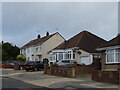
The property market in RM3 7AJ is heavily weighted towards owner-occupied households. Home ownership levels reach 58%, creating a stable environment for residents who have built equity in their properties. Houses form the predominant accommodation type within this 1.3 hectare site. This structure dictates the character of the local housing stock and the likely appearance of new listings. You will find a shortage of flats or apartments compared to other London postcodes. The high ownership rate implies that sales turnover may be slower than in areas dominated by private rentals. Buyers should expect a market where long-term residents remain settled in their homes. The exclusive focus on houses means options for larger family units or those preferring garden space are naturally favoured. This configuration supports families seeking traditional living arrangements rather than urban apartment living. The small area size reinforces the scarcity of available properties, making any sale event in RM3 7AJ relatively notable. Purchasing here adds you to the majority of people who have invested in this specific community.
House Prices in RM3 7AJ
Showing 27 properties
| Address | Type | Beds | Baths | Last Sale Price | Last Sale Date | |
|---|---|---|---|---|---|---|
| 86 Harrow Crescent, Romford, RM3 7AJ | Bungalow | - | - | £500,000 | Feb 2025 | |
| 68 Harrow Crescent, Romford, RM3 7AJ | Bungalow | 2 | - | £375,000 | Sep 2021 | |
| 96 Harrow Crescent, Romford, RM3 7AJ | Bungalow | - | - | £400,000 | Aug 2021 | |
| 94 Harrow Crescent, Romford, RM3 7AJ | house | - | - | £340,000 | Nov 2020 | |
| 70 Harrow Crescent, Romford, RM3 7AJ | Bungalow | - | - | £363,000 | Feb 2018 | |
| 44 Harrow Crescent, Romford, RM3 7AJ | Bungalow | 4 | 1 | £390,000 | May 2017 | |
| 38 Harrow Crescent, Romford, RM3 7AJ | Semi-detached | 1 | - | £182,000 | Jun 2015 | |
| 38A Harrow Crescent, Romford, RM3 7AJ | Bungalow | 3 | 1 | £176,000 | May 2015 | |
| 36 Harrow Crescent, Romford, RM3 7AJ | Bungalow | 3 | - | £260,000 | Mar 2014 | |
| 62 Harrow Crescent, Romford, RM3 7AJ | Bungalow | 2 | 1 | £210,000 | Sep 2013 |
Energy Efficiency in RM3 7AJ
Integrated with the postcode is your ready access to five major supermarkets including Budgens Romford, Budgens MRH, and Tesco Romford. These retail venues are located within practical reach of every residence in the area. You do not need to travel far for groceries or household necessities. Five railway stations serve the wider community, offering access to Gidea Park Station, Harold Wood Station, and Emerson Park Station. The local transit network also includes five metro stations such as Upminster Bridge, Hornchurch, and Elm Park Station. This combination of rail and metro options provides versatile transport links. Daily errands involve walking to Tesco or catching a train from Harold Wood Station for commuters. The concentration of five retail outlets ensures diverse shopping choices are never more than a short journey away. Your morning coffee might come from aTesco meal deal at home, while your lunch relies on the convenience of these established stores.
Amenities
Schools
| Rank | School | Type | Entry gender | Ages |
|---|
Explore more schools in this area
Go to Schools tabDemographics
The community in RM3 7AJ is defined by a mature demographic profile. The median age stands at 47 years old across the population of 1,787 residents. Adults between 30 and 64 years represent the most common age range within this area. This age distribution suggests a neighbourhood populated by established families and professionals rather than young students or students leaving home shortly. Home ownership is significant here with a recorded rate of 58%. More than half of the residents own their properties outright or with a mortgage. This contrasts with predominantly rental areas where long-term stability might differ. The accommodation type is exclusively houses, indicating a preference for detached or semi-detached living over flat options. The predominant ethnic group is White, reflecting the demographic composition of this specific postcode sector in England. Understanding these figures provides a clear picture of the lifestyle and social dynamics you would encounter. You are joining a segment of the population that values stability and home ownership.
Household Size
Accommodation Type
Tenure
Ethnic Group
Religion
Household Composition
Age
Household Deprivation
NS-SEC
Explore more demographic insights in this area
Go to Demographics tabPlanning
Planning Constraints
- Flood RiskPremium
- Ramsar Wetland SitesPremium
- Area of Outstanding Natural BeautyPremium
- Protected Nature ReservePremium
- Protected WoodlandPremium