Area Overview for RM14 2UX
Photos of RM14 2UX


Area Information
Norman Alright, an unnamed postcode area in the Dagenham and Redbridge borough of east London, finds itself a compact residential cluster. The specific code RM14 2UX covers a surprisingly small footprint of 5,387 square metres. Despite its modest physical size, the location accommodates a population of 1,639 residents. This density creates a distinct living environment within the broader Essex/London border region. You are entering a zone defined by its status as a postcode rather than a traditional village or town centre. The population density here reaches 304,225 people per square kilometre, a figure that reflects the concentrated nature of the address itself. Living in this postcode cluster means you are part of a tight-knit group within a larger urban fabric. The area sits close to significant transport nodes and commercial hubs without holding them internally. Your daily commute and leisure activities will extend beyond these specific boundaries to include neighbouring stations and towns. This locality represents a specific slice of the wider Upminster corridor, offering a residential setting directly linked to major infrastructure. You are situated where practicality meets proximity to the wider network of east London connectivity.
- Area Type
- Postcode
- Area Size
- 5387 m²
- Population
- 1639
- Population Density
- 3431 people/km²
The property market in RM14 2UX is defined by a dominant presence of houses and a very strong owner-occupier culture. With 83% of residents owning their homes, the area functions more as an established residential patch than a letting district. This high level of ownership means you will encounter fewer buy-to-let landlords compared to other parts of east London. The accommodation type is explicit: houses. This suggests a landscape of terraced, semi-detached, or detached properties rather than the high-rise blocks common in central London. Buying a home here offers the stability of a neighbourhood where most people have turned their backs on renting. The small area size of 5,387 square metres implies that the housing supply is limited for any given expansion project. Inventory might be tight if you seek a specific architectural style within this postcode. The market reflects the choices of a demographic aged 30 to 64 years, who value space and tenure security. You are entering a market where sellers know that most of their neighbours are similarly invested. This reduces the volatility often seen in transient rental zones. The high ownership ratio also correlates with lower maintenance issues from previous short-term tenancies. Investors should expect a traditional housing market dynamics rather than the rapid turnover of a rental hotspot.
House Prices in RM14 2UX
Showing 10 properties
| Address | Type | Beds | Baths | Last Sale Price | Last Sale Date | |
|---|---|---|---|---|---|---|
| 8 Aylett Road, Upminster, RM14 2UX | Semi-detached | 2 | 1 | £410,000 | Jan 2025 | |
| 10 Aylett Road, Upminster, RM14 2UX | Bungalow | 4 | 2 | £760,000 | Dec 2024 | |
| 5 Aylett Road, Upminster, RM14 2UX | Detached | 3 | 1 | £750,000 | Oct 2020 | |
| 7 Aylett Road, Upminster, RM14 2UX | house | - | - | £478,000 | Jan 2016 | |
| 1 Aylett Road, Upminster, RM14 2UX | Bungalow | 5 | - | £585,000 | Apr 2014 | |
| 9 Aylett Road, Upminster, RM14 2UX | Semi-detached | 4 | - | £418,000 | Apr 2009 | |
| 2 Aylett Road, Upminster, RM14 2UX | Detached | - | - | £271,000 | Mar 2002 | |
| 6 Aylett Road, Upminster, RM14 2UX | Bungalow | 3 | 1 | £145,000 | Jun 2000 | |
| 3 Aylett Road, Upminster, RM14 2UX | Detached | - | - | - | - | |
| 4 Aylett Road, Upminster, RM14 2UX | Detached | - | - | - | - |
Energy Efficiency in RM14 2UX
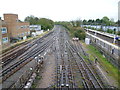
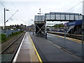
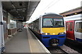
Your daily lifestyle in RM14 2UX relies on nearby amenities located within practical walking or short driving distance. Retail options include Waitrose Upminster, The Southern Co-operative Co, and M&S Upminster SF. These high street names offer essential groceries and daily necessities close to your doorstep. For transport links, five rail stations serve the broader area, including Upminster Station, Emerson Park Station, and Harold Wood Station. These stations provide straightforward access to central London and surrounding counties without the need for a car every day. The network of tracks extends via Upminster Bridge, Hornchurch, and Elm Park Station, creating a layered transport web. You do not have to drive for basic mobility or weekend trips to the city. Dining and shopping outlets are consolidated in nearby towns rather than scattered internally across this small postcode. This layout means your weekend supermarket run could start just minutes from your front door while your Monday commute begins at a station a short journey away. The amenities listed are substantial enough to support a full weekly routine. You gain the convenience of large supermarkets and central rail hubs while living in a quieter residential cluster.
Amenities
Schools
Parents in RM14 2UX have access to education facilities that cater to young learners, with The Coopers Company and Coborn School serving as the primary institution for children. This school operates as both a primary and an academy, providing a consistent educational path for students in the local catchment. The academy status of The Coopers Company and Coborn School indicates it operates under its own governance while adhering to the same standards as the primary setting. Crucially, the Ofsted rating for this institution is good. This rating offers confirmed quality assurance for families moving into the postcode. The mix of school types ensures that residents do not need to travel far for core education. You will find a single, rated option listed for this specific area, which simplifies the school selection process for local buyers. The presence of a rated academy alongside a primary designation means the school bodies are integrated. This setup supports standard curriculum delivery without complex multi-academy trust navigation for local catchment children. Families can rely on the good rating when assessing the area suitability for their offspring. There are no secondary schools listed specifically within the immediate data for this postcode, suggesting you may look slightly wider for older children depending on the current boundary definitions. The local education provision is focused, centred on this single named entity.
| Rank | School | Type | Entry gender | Ages |
|---|
Explore more schools in this area
Go to Schools tabDemographics
The community in RM14 2UX is heavily dominated by owner-occupiers, with 83% of households owning their homes outright or with a mortgage. This high ownership rate signals a settled population with long-term roots in the area. Most residents are adults aged between 30 and 64 years, which shapes the neighbourhood's character and demand for specific housing types. The area is primarily residential, consisting mainly of houses rather than flats or urban apartment blocks. This accommodation type aligns with the homeowner demographic, suggesting detached or semi-detached properties form the core of the stock. White ethnicity remains the predominant group within this postcode. The age profile of 47 years as the median indicates a mature community, likely composed of families or empty nesters. You will find a stable social environment where residents have established themselves over time. The lack of young adult clusters or significant student populations differentiates this from adjacent university zones. Daily life revolves around a demographic seeking stability and space. The housing stock supports families who have already moved past the initial rental phase of their lives. This demographic make-up ensures a consistent demand for maintenance and local services tailored to house owners.
Household Size
Accommodation Type
Tenure
Ethnic Group
Religion
Household Composition
Age
Household Deprivation
NS-SEC
Explore more demographic insights in this area
Go to Demographics tabPlanning
Planning Constraints
- Flood RiskPremium
- Ramsar Wetland SitesPremium
- Area of Outstanding Natural BeautyPremium
- Protected Nature ReservePremium
- Protected WoodlandPremium