Area Overview for NW9 9JE
Photos of NW9 9JE

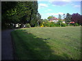
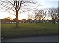
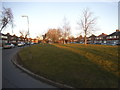
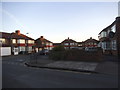
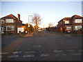
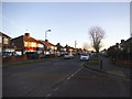
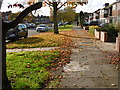
48 photos from this area
Area Information
Key information about the NW9 9JE including its size, population, and administrative classification.
- Area Type
- Postcode
- Area Size
- 1.3 hectares
- Population
- 2183
- Population Density
- 6769 people/km²
House Prices in NW9 9JE
41
Properties
£320,211
Average Sold Price
£42,500
Lowest Price
£688,000
Highest Price
Showing 41 properties
| Address | Type | Beds | Baths | Last Sale Price | Last Sale Date | |
|---|---|---|---|---|---|---|
| 146 Princes Avenue, London, NW9 9JE | Semi-detached | 3 | - | £600,000 | Sep 2025 | |
| 176 Princes Avenue, London, NW9 9JE | house | 3 | - | £600,000 | Sep 2025 | |
| 136 Princes Avenue, London, NW9 9JE | Semi-detached | 4 | 2 | £688,000 | Aug 2025 | |
| 156 Princes Avenue, London, NW9 9JE | Semi-detached | - | - | £580,000 | May 2023 | |
| 166 Princes Avenue, London, NW9 9JE | Semi-detached | 3 | 1 | £500,000 | Sep 2019 | |
| 130 Princes Avenue, London, NW9 9JE | house | - | - | £456,000 | Aug 2017 | |
| 154 Princes Avenue, London, NW9 9JE | Semi-detached | 3 | - | £440,000 | Jun 2015 | |
| 174 Princes Avenue, London, NW9 9JE | house | - | - | £370,000 | May 2013 | |
| Former, 142 Princes Avenue, London, NW9 9JE | Detached | - | - | £319,000 | Oct 2012 | |
| 178 Princes Avenue, London, NW9 9JE | house | - | - | £367,500 | Dec 2011 |
Page 1 of 5
Energy Efficiency in NW9 9JE
Amenities
Schools
| Rank | School | Type | Entry gender | Ages |
|---|
Explore more schools in this area
Go to Schools tabDemographics
Household Size
Family (3-5 people)
most common
Accommodation Type
Houses
most common
Tenure
48
majority
Ethnic Group
asian_total
most common
Religion
N/A
most common
Household Composition
N/A
most common
Age
47
median
Adults (30-64 years)
most common
Household Deprivation
N/A
with no deprivation
NS-SEC
21
in Lower managerial occupations
Explore more demographic insights in this area
Go to Demographics tabPlanning
Planning Constraints
- Flood RiskPremium
- Ramsar Wetland SitesPremium
- Area of Outstanding Natural BeautyPremium
- Protected Nature ReservePremium
- Protected WoodlandPremium