Area Overview for NW7 2SE
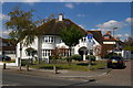
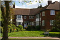
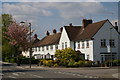
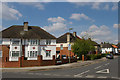
Photos of NW7 2SE
Area Information
Living in the NW7 2SE postcode cluster places you in a defined residential zone covering 4963 square metres within England. This specific area accommodates a population of 2166 residents, creating a relatively compact community footprint. The density here reaches 436444 people per square kilometre, reflecting the nature of small residential clusters in this part of the property market. Daily life here is characterised by a focus on immediate proximity, as the area functions as a distinct pocket within the wider local network. You are part of a group of neighbours in a location that prioritises residential living over sprawling development. The size of the postcode area means that your daily journey often begins just steps from your front door, fitting neatly into the routine of a homebuyer seeking a contained environment. This small geographical scale defines the character of neighbourhood interactions and access to immediate needs. You find yourself in a setting where every street plays a specific role within this tight-knit spatial arrangement.
- Area Type
- Postcode
- Area Size
- 4963 m²
- Population
- 2166
- Population Density
- 2653 people/km²
The property market in NW7 2SE is defined by a strong偏向 towards ownership, with 55% of residents buying their own homes. This high ownership rate suggests a stable environment where families and individuals build equity over time rather than cycling through short-term tenancies. Houses are the main form of accommodation here, meaning you will primarily encounter standalone family dwellings rather than converted flats or high-rise blocks. Buying a home in this small postcode is an investment in a property type that aligns with the established character of the area. The dominance of house ownership indicates that the local demand is for properties suited to homeownership models. When looking at homes in NW7 2SE, you are engaging with a market where residents have deep roots and a commitment to local improvement. This economic profile supports long-term value retention and a quieter, less transient street scene compared to areas with high rental turnover.
House Prices in NW7 2SE
Showing 18 properties
| Address | Type | Beds | Baths | Last Sale Price | Last Sale Date | |
|---|---|---|---|---|---|---|
| 17 Burnham Close, Mill Hill, London, NW7 2SE | Semi-detached | 2 | 1 | £510,000 | Mar 2025 | |
| 4 Burnham Close, Mill Hill, London, NW7 2SE | Semi-detached | 3 | 2 | £600,000 | Oct 2024 | |
| 1 Burnham Close, Mill Hill, London, NW7 2SE | Semi-detached | 4 | 1 | £675,000 | Mar 2023 | |
| 15 Burnham Close, Mill Hill, London, NW7 2SE | Semi-detached | 3 | 1 | £550,000 | Jan 2023 | |
| 8 Burnham Close, Mill Hill, London, NW7 2SE | house | - | - | £480,000 | Nov 2015 | |
| 18 Burnham Close, Mill Hill, London, NW7 2SE | house | 4 | - | £425,000 | Aug 2011 | |
| 16 Burnham Close, Mill Hill, London, NW7 2SE | Semi-detached | 2 | 1 | £277,000 | Dec 2010 | |
| 12 Burnham Close, Mill Hill, London, NW7 2SE | Semi-detached | - | - | £275,000 | Mar 2006 | |
| 6 Burnham Close, Mill Hill, London, NW7 2SE | Terraced | - | - | £250,000 | Aug 2003 | |
| 7 Burnham Close, Mill Hill, London, NW7 2SE | house | 3 | - | £160,000 | Mar 2000 |
Energy Efficiency in NW7 2SE
Daily life for residents of NW7 2SE revolves around a practical array of nearby amenities including shops, stations, and water transport links. You have access to five major retail locations such as M & S Watford Way BP, Tesco Hendon, and Sainsburys Colindale. These superstores provide convenient access to groceries and household goods without requiring long journeys. Transport connectivity is further enhanced by five notable railway stations like Mill Hill Broadway and Hendon Station, as well as five metro stops including Colindale Station and Burnt Oak Station. Two ferry services are also available at the London Zoo Waterbus Stop and Camden Lock Waterbus, offering weekend leisure options. This mix of retail chains and transport hubs means you rarely need to travel far for essential errands or social activities. The immediate availability of these five retail outlets, five rail links, and five metro stops creates a lifestyle defined by convenience. You can manage daily shopping, commuting, and leisure visits from the safety and comfort of your home in this postcode.
Amenities
Schools
Families living in or near NW7 2SE have access to Hasmonean High School for Girls as their nearest primary educational option. This institution operates as an academy and currently holds a 'good' Ofsted rating. The presence of a single named school in the immediate vicinity highlights the specific educational provision available directly adjacent to the area. While Hasmonean High School for Girls serves this immediate cluster, the nearest designation suggests that further options likely exist within the broader borough for younger children or extended education needs. The academy status indicates a modern governance structure separate from direct local authority control. For parents considering schools near NW7 2SE, this 'good' rating provides a reassurance of educational standards. The concentration of educational resources around one main institution shapes the daily logistics for families relying on walking distance or local catchment zones.
| Rank | School | Type | Entry gender | Ages |
|---|
Explore more schools in this area
Go to Schools tabDemographics
The community in NW7 2SE is dominated by adults between the ages of 30 and 64 years. The median age for residents here is 47, indicating a mature demographic rather than one filled with families raising young children or empty-nester retirees. Fifty-five per cent of households in this area own their homes, which places the community firmly within the owner-occupied sector rather than the rental market. Houses are the predominant accommodation type, shaping the visual character and street layout of the postcode zone. The area is predominantly White, reflecting the primary ethnic group among its population. This profile suggests a stable, established neighbourhood where long-term residents maintain a significant presence. The age structure implies that the local amenities and services are tailored to the needs of working adults and those approaching retirement, rather than catering primarily to early childhood education or playgroups.
Household Size
Accommodation Type
Tenure
Ethnic Group
Religion
Household Composition
Age
Household Deprivation
NS-SEC
Explore more demographic insights in this area
Go to Demographics tabPlanning
Planning Constraints
- Flood RiskPremium
- Ramsar Wetland SitesPremium
- Area of Outstanding Natural BeautyPremium
- Protected Nature ReservePremium
- Protected WoodlandPremium